THE SA INFORMAL CITY ONLINE EXHIBITION
UN-BUILT PROJECTS: RESEARCH AND REFLECTIONS
- Diepsloot – Housing & The Informal City
Exhibitor: 26’10 South Architects and Lone Poulsen - Diepsloot - Soak & Curl
Exhibitor: 26’10 South Architects - Informal Studio - Ruimsig
Exhibitor: 26’10 South Architects - Sans Souci Cinema
Exhibitor: 26’10 South Architects, Lindsay Bremner - Subsidised Housing Assets
Exhibitor: FinMark Trust
BACKYARD / OWNER INTERVENTIONS
- Flats of Du Noon
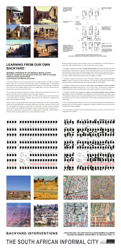
Exhibitor: Heinrich Wolff - Learning from our own backyard?
Exhibitor: Lone Poulsen and Melinda Silverman
INNER CITY INFORMALITY
- Brook Street Market
Exhibitor: Architects Collaborative cc - eKhaya Neighbourhood Project
Exhibitor: Savage + Dodd Architects - Inner City Movement Framework
Exhibitor: Monica Albonico and Lone Poulsen - Jeppe: ‘The Chaos Precinct’
Exhibitor: Dr Tanya Zack and Robyn Arnot - Recycle Change
Exhibitor: Tanya Zack/ Sarah Charlton/ Bronwyn Kotzen - Warwick Bridge
Exhibitor: designworkshop : sa
IN-SITU UPGRADING
- Besters Camp
Exhibitor: Harber & Associates - eThekwini Municipality
Exhibitor: eThekwini Municipality, Aurecon and Project Preparation Trust - Home Improvements
Exhibitor: FinMark Trust - Kliptown Explored
Exhibitor: Monica Albonico and Lone Poulsen - Lion Park
Exhibitor: Michael Hart Architects Urban Designers
CATALYTIC PROJECTS
- Integrated Neighbourhood - Slovo Park
Exhibitor: Michael Hart Architects Urban Designers - SAPS Retreat Railway Police Station
Exhibitor: Makeka Design Lab - The Aesthetics of Safety
Exhibitor: Makeka Design Lab - Urban Acupuncture - Khayelitsha
Exhibitor: Makeka Design Lab
BACKYARD / OWNER INTERVENTIONS
Below is a brief excerpt from each of the projects in this category. Click on the links or image to see the full project panel details and illustrations.
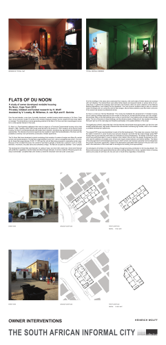
Flats of Du Noon
Exhibitor: H. Wolff
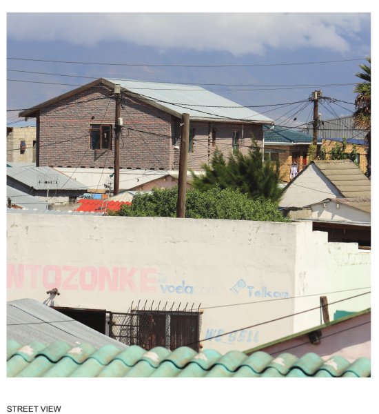
Over the past decade, a new type of privately developed, rentable housing started emerging in Du Noon, Cape Town. As an economic model it is similar to the renting of backyard shacks, but the rentals are three times higher on average. The extraordinary income-generating potential of the flats in Du Noon and their morphological innovation is what sparked interest in this study.
Learning from our own backyard
Exhibitor: Lone Poulsen and Melinda Silverman
At the back of almost every formal house in South Africa is an additional building. This might be a servant's quarter, a granny flat, 'a room for rent', an informal shop, a spaza or a hairdressing salon . In many instances these backyard rooms have been informally developed built by the owners of the formal house in an attempt to derive income from their properties. Backyard rooms are a notable feature of the South African urban landscape and have a long history in South African cities
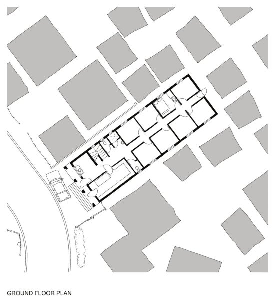
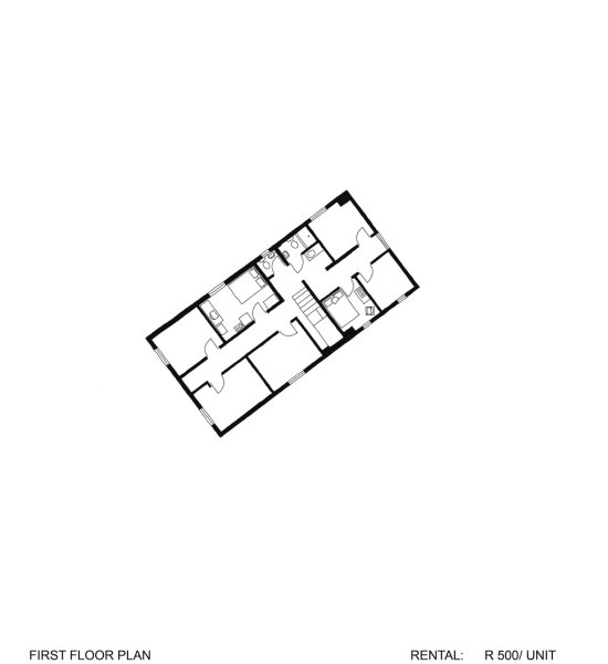
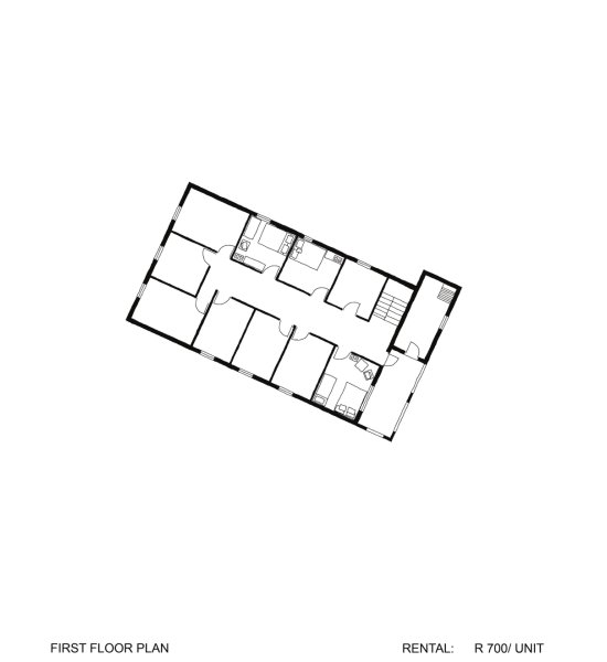
Flats of Du Noon

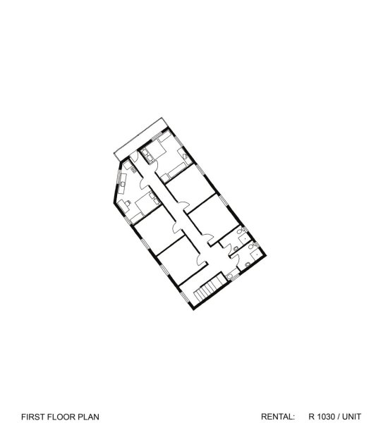
FLATS OF DU NOON
A study of owner developed rentable housing
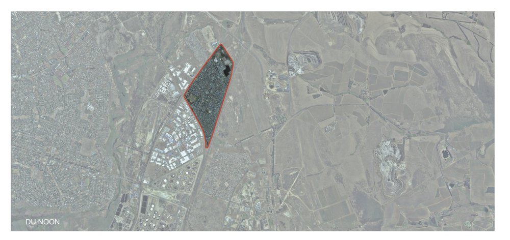
Du Noon, Cape Town 2010
Privately initiated and funded research by H. Wolff
Assisted by V. Loseby, M. Willemse, A. van Wyk and E. Gericke
Over the past decade, a new type of privately developed, rentable housing started emerging in Du Noon, Cape Town. As an economic model it is similar to the renting of backyard shacks, but the rentals are three times higher on average. The extraordinary income-generating potential of the flats in Du Noon and their morphological innovation is what sparked interest in this study.
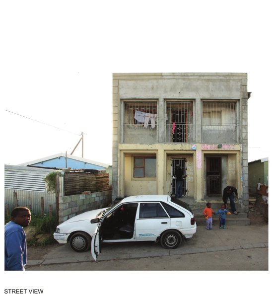
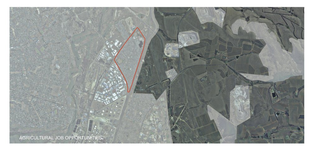
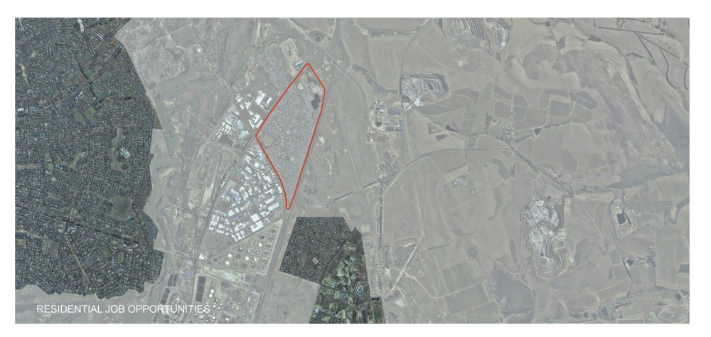
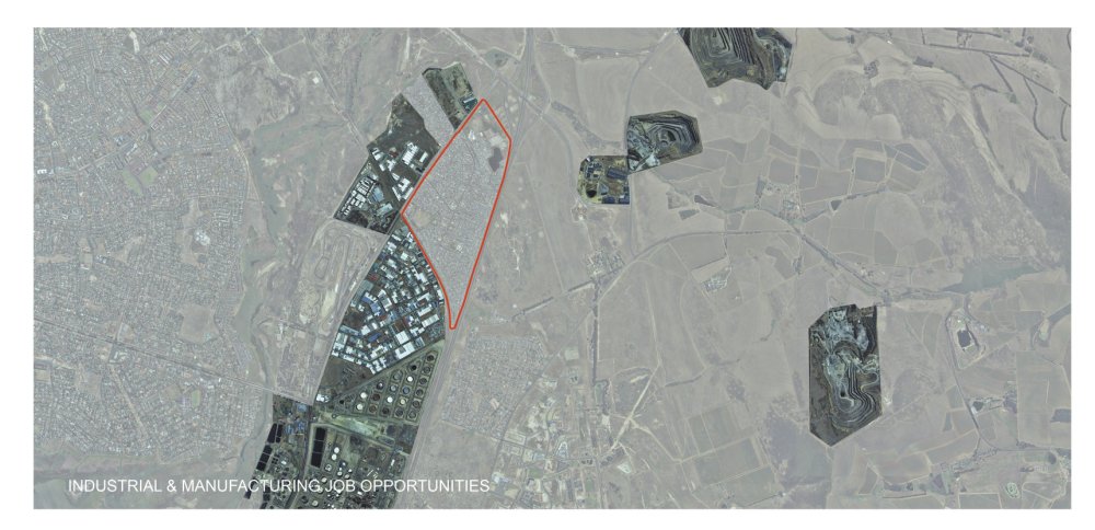
Du Noon is a Post-Apartheid settlement that owes its origins to a Provincial Governmental housing roll-out that started in 1996. Typically a 38m' RDP house would be built in the centre of a 115m' property. As an area for social housing, Du Noon is uncharacteristically well located near industrial, manufacturing, agricultural and residential job opportunities. The intensity of economic opportunity has resulted in rapid informal densification of Du Noon and the possibility to develop more permanently constructed, rentable apartments.
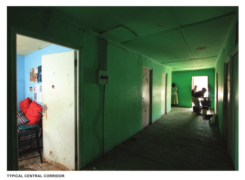
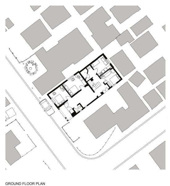
The Du Noon flats have developed a typical morphology that consists of a series of single room flats off a central corridor with shared ablutions. The flat sizes range between 6 and 13m2, with an average flat size of 8m'. The rentals for these flats range between R 400 - R 1030 per flat, with all flats being occupied in reasonably similar ways. Because of the consistent flat sizes, the content of each flat is typically a double bed, cupboard, couch or chairs, television , microwave, two plate stove and sometimes a fridge . The flats are occupied by between 1 and 4 people.
- click images to see larger version -
The development of these flats was financed in a variety of ways , but never with a bank loan. Some were financed with profits from vegetable or alcohol trade and others through stokvels. A common method of financing was to develop incrementaliy- completed flats were rented out while the remainder were still under construction.
All of the buildings in the study were constructed from masonry, with roofs made of timber beams and covered with roof sheeting. The internal floors were either timber beams and plywood boards or various forms of concrete floors. In general the buildings were built fairly well however, there are some violations of the National Building Regulations, most notably the fire regulations. The most common problems being a lack of a second means of escape and non-conformity with the stair designs. Most of these problems could have been overcome if the owners had access to professional advice.
Du Noon is zoned as 'Informal Residential'. This zoning has facilitated the development of rentable housing, due to it placing unlimited restrictions on the number of units per erf, provided that the primary use is for residential purposes. Many of the flat buildings have a shop on ground floor, one building even provides rentable office space. The mix of functions in these buildings, and the extreme density of flats per erf, has resulted in buildings that push right up to the road edge and therefore participates in the spatial definition of the street.
Due to Reception Area’s complex and dense urban fabric, the strategy is realized in three scales: an existing toilet upgrade, a medium-sized toilet and shower facility, and a large service centre with toilets, comfortable bathrooms, laundry and community services.
The large units are arranged around semi-private courtyards. Besides regular bathrooms, they contain retail spaces which could be used by a hairdresser, internet cafe, laundry, tuck-shop, crèche, gym, etc. The two roof terraces can be used for drying clothes and by the gym as outdoor exercising spaces respectively.
Through incorporating lessons learnt from the dynamic urban and architectural character of the Reception Area, the facilities are cross-programmed to offer multiple services and income streams. All typologies would provide business opportunities for local caretakers and operators.
Continued on Panel 2.
HEINRICH WOLFF
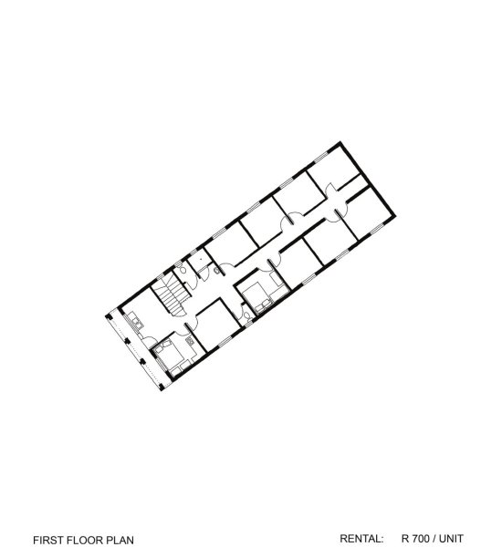
Flats of Du Noon (Panel 2)
- click images to see larger version -
FLAT DATA
| Average unit size: | 8m2 | ||
| Typical rental: | R 700 / month | ||
| R 50 - R100 / m2 | |||
| R 45 - R 80 / m2 | (including ablutions) | ||
| Comparative rentals: | R 700 ÷ 8m2 | = R 88 / m2 | DU NOON |
| R 3500 ÷ 40m2 | = R 88 / m2 | CAPE TOWN CITY | |
| R 3000 ÷ 40m2 | = R 75 / m2 | BANTRYBAY | |
| R 3500 ÷ 40m2 | = R 88 / m2 | BANTRY BAY (upmarket) | |
| R 2850 ÷ 40m2 | = R 71 / m2 | BLOUBERG | |
| R 2650 ÷ 40m2 | = R 66 / m2 | DURBANVILLE |
Back to Panel 1.
HEINRICH WOLFF
Learning From Our Own Backyard
LEARNING FROM OUR OWN BACKYARD
Informal provision of affordable rental stock
Research conducted into backyard rental since 2002 for amongst others the GDoH and the NDoH
Lone Poulsen and Melinda Silverman
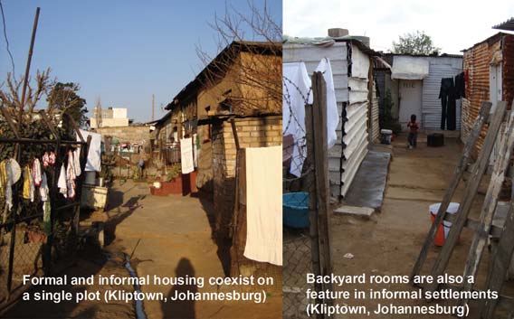
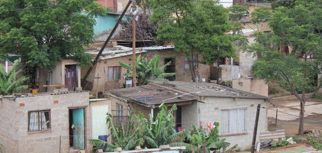
At the back of almost every formal house in South Africa is an additional building. This might be a servant's quarter, a granny flat, 'a room for rent', an informal shop, a spaza or a hairdressing salon . In many instances these backyard rooms have been informally developed built by the owners of the formal house in an attempt to derive income from their properties. Backyard rooms are a notable feature of the South African urban landscape and have a long history in South African cities:
Over a hundred years residents of Alexandra built clusters of rental rooms on their large peri-urban plots. This gave rise to the "Alex yard" which remains the primary social entity in Alexandra. In the townships developed by Apartheid government in the 1950s, residents gradually added backyard rooms in spite of state efforts to curb African urbanisation. New rooms were often disguised as "a garage and two stores" when such additions were illegal.
Today the pattern of building backyard rooms remains popular. Beneficiaries of the RDP housing programme rolled out by the post-Apartheid state have also been adding rooms at the backs of their plots. During the 1990s more new tenancies were created in the informal than the formal sector, most often in the form of backyard rooms. The 2001 census counted 460 000 households, or about 2.3 million people, living in backyard rooms. Until recently "backyard shacks" have been viewed in a negative light by the authorities - largely because the increase in density has placed significant strain on existing infrastructural services.
Although the quality of backyard rooms is often poor, this form of accommodation - built entirely without government help - offers potential solutions to a number of South African housing problems.
1. The addition of backyard rooms helps to increase housing density, which means that urban land is used more efficiently. The same amount of road space and the same length of pipe runs can be used to serve additional households. Increased urban densities also generate higher thresholds for public transport, retail and social services making these amenities more viable. Additional rooms on the plot often help to define better outdoor space, creating courtyards where children can play and residents can socialise.
2. The addition of backyard rooms allows the owner of the primary dwelling to derive income from his/her property in the form of rental rooms or home enterprises. This means that a house provides more than shelter and also functions as an economic generator. This increases the asset value of the property.
3. The addition of backyard rooms provides accommodation that is more responsive to diverse household arrangements where families are rarely nuclear - mom, pop and 2.5 kids - but more likely to comprise grannies looking after AIDs orphans, extended families , women headed households, and multiple households.
4. The addition of backyard rooms improves the supply of much-needed affordable rental accommodation, fulfilling the needs of an estimated 80% of the population who cannot afford formal rental housing. Cheap rental options are necessary in the context ongoing migrancy where work in cities, but maintain links with families elsewhere and in the context of increasing labour mobility where urban residents are forced to move in search of jobs.
5. From a municipal perspective backyard rooms are a far less alarming manifestation of informality than freestanding shacks which are often erected on inappropriate or unsafe land. Backyard rooms are built on land that has already been zoned as residential.
It is for these reasons that backyard rooms are increasing being seen as a solution to South Africa's housing shortage rather than a problem.
Continued on Panel 2
.
LONE POULSEN: ACG ARCHITECTS & DEVELOPMENT PLANNERS
MELINDA SILVERMAN: DEPARTMENT OF ARCHITECTURE: UJ
Learning From Our Own Backyard (Panel 2)
LEARNING FROM OUR OWN BACKYARD
New models of affordable housing
Research conducted into backyard rental since 2002 for amongst others the GDoH and the NDoH
Lone Poulsen and Melinda Silverman
The backyard room is receiving increasing attention from South African policy makers and design professionals as a potential solution to some of South Africa's most pressing housing problems - excessively low densities, a shortage of affordable rental housing, housing units designed only for nuclear families.
Informed by these theories and observations of organically developed backyard rooms, architects and urban designers have started to develop housing models that anticipate and make provision for backyard additions. These new housing prototypes harness the advantages of backyard accommodation while seeking to mitigate the disadvantages associated with unplanned, unanticipated densification.
These new models are characterised by:
Reduced plot sizes. This ensures that urban land - an increasingly scarce resource - is used more efficiently.
Narrow street frontages. This reduces the amount of road space and pipe runs needed to serve individual plots. This results in significant savings in both the capital and operating costs of services.
Unorthodox siting of the starter unit. Rather than locating the house in the middle of the plot, as per conventional suburban housing, the starter unit is located near the front of the site and along one of the side boundaries. This immediately creates an identifiable street edge, allows for street-related commercial activities like
spazas, maximises the amount of useable outdoor space, and ensures that adequate space is available at the back of the site for the incremental addition of backyard rooms.
Building the starter unit as a double storey. This ensures that the building footprint is reduced maximising the amount of outdoor space.
The advantages of these new housing models are manifold:
They increase densities and therefore make more effective use of infrastructure;
They can be developed incrementally as the primary homeowner acquires more capital;
They harness the entrepreneurial talents of the community and provide jobs for small contractors;
They disperse political risk amongst a large number of small landlords;
They accommodate a wide variety of living arrangements on the same plot - multiple households, home-based enterprises, a mix of freehold and rental tenure.
These principles have already been realised in a number of exemplary projects across the country:
In the PELIP project in Nelson Mandela Bay, Noero Wolff developed a row house typology with two and three storey units. Each unit was conceptualised as a starter house, designed to allow beneficiaries to customise their housing in accordance with their own requirements. Units are narrow and built right up against the street edge, allowing for flexible space in the back yard to accommodate additions or rentable rooms.
In the Far East Bank project in Alexandra, in Johannesburg, ASA Architects developed clusters of six to eight units with a mix of double storey main houses and single storey rental rooms. Some beneficiaries are renting out the rooms to tenants and some are using the rooms to operate small businesses. The road space within each cluster functions as a contained courtyard proViding a safe space for children to play.
In the 10x10 project in Freedom Park, a suburb in Cape Town, MMNLuyanda Mpahlwa architects developed two-story timber frame and sandbag infill row houses, designed and built with community involvement. The houses are placed close to one another on the street edge, immediately contributing to a sense of urbanity.
In Lufhereng, in Mogale City, 26°10 South and Peter Rich Architects created row-houses comprising single and double-storey units which afford a sense a variety. The houses are built close to the street edge with private gardens at the back. The use of smaller-than-usual stands has helped increase residential densities and some residents have already converted rooms into tuck-shops and hairdressing salons.
Back to Panel 1.
LONE POULSEN: ACG ARCHITECTS & DEVELOPMENT PLANNERS
MELINDA SILVERMAN: DEPARTMENT OF ARCHITECTURE: UJ
CATALYTIC PROJECTS
Below is a brief excerpt from each of the projects in this category. Click on the links or image to see the full project panel details and illustrations.
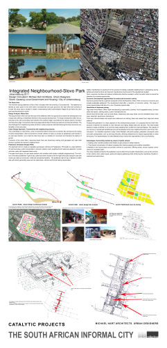
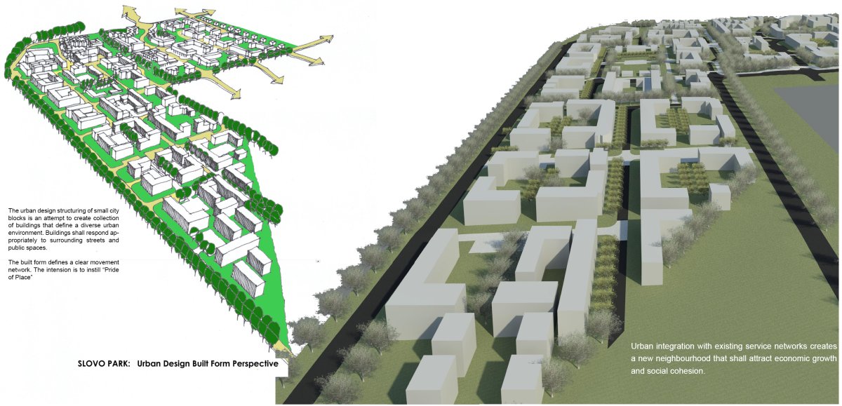
Integrated Neighbourhood - Slovo Park
Exhibitor: Michael Hart Architects Urban Designers
The informal housing settlement of Slovo Park is located within the township of Coronationville. The settlement is flanked by open space to the north within Coronationville and open ground to the east within the township of Crosby.The study area is located in western Johannesburg within Administration Region B and within the city's east west development corridor.
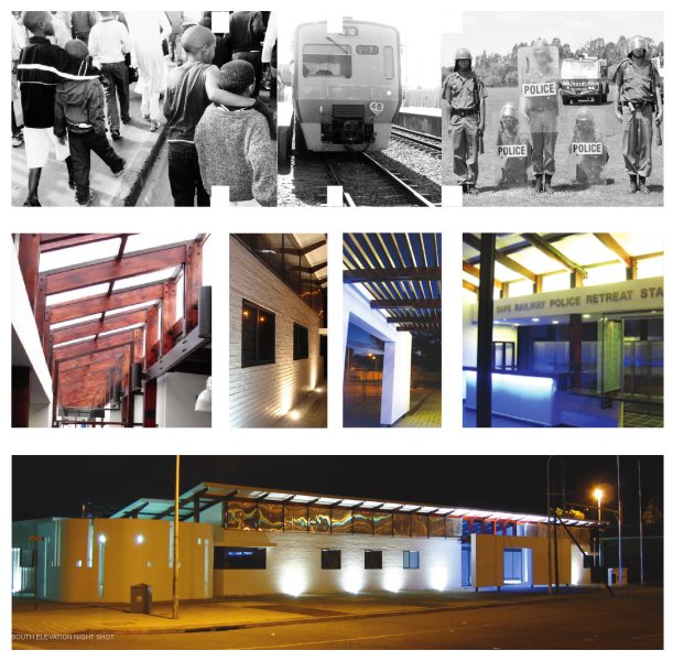
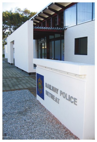
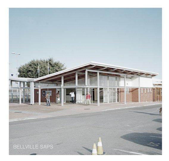
SAPS Retreat Railway Police Station
Exhibitor: Makeka Design Lab
The Retreat Railway Police Station acknowledges that a better public engagement can be fostered by fashioning spaces and environments that promote transparency and visibility, which are open and welcoming, and most importantly are safe and accessible. The building plays its part in the narrative of a better, more efficient and more connected South African Police Service to be used and accessed by the citizens it serves.
The Aesthetics of Safety
Exhibitor: Makeka Design Lab
Rail is the accepted backbone of public transport in the Western Cape, contributing almost 59% of the total public transport profile, which in turn is responsible for 29% of the total transport profile in the city. The railway police force were disbanded during the late 1980’s after enduring allegations of acting as an enforcer for the apartheid regime, stricken by rumours of state sanctioned torture and other human rights abuses. The dissolution of this specialised police unit later proved to be a liability post 1994 with escalating crime on trains and at various train station stations, including vandalism, aggravated robbery, and violent assaults etc.
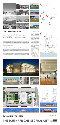
Urban Acupuncture - Khayelitsha
Exhibitor: Makeka Design Lab
Khayelitsha is the largest and last township to be formally established in the Western Cape. Located at the heart of the Cape Flats and abutting Mitchel’s Plain, its narrative of dislocation, hope, and unequal access to resources, amenity and infrastructure positions the area as an exemplar of Apartheid informed informality. President Thabo Mbeki identified it as one of twenty national urban renewal nodes with a specific role to play in terms of social cohesion, upliftment and integration across the fractured cultural divide. The central business district was conceived to create a new urban room, an inspirational public realm for a devastated and desolate community lacking any resilient hierarchy of formalised ‘publicness.’
Integrated Neighbourhood - Slovo Park
INTEGRATED NEIGHBOURHOOD - SLOVO PARK
Johannesburg 2011
Design Consultant: Michael Hart Architects. Urban Designers
Client: Gauteng Local Government and Housing / City of Johannebsurg
The Study Area
The informal housing settlement of Slovo Park is located within the township of Coronationville. The settlement is flanked by open space to the north within Coronationville and open ground to the east within the township of Crosby.The study area is located in western Johannesburg within Administration Region B and within the city's east west development corridor.
Design Analysis :Status Quo
The acquired land to the north and the east of the settlement offer the opportunity to extend the development over a larger area offering a Greenfields element to the proposed development. The larger development offers the opportunity to link with surrounding road networks.The southern edge is bounded by the railway reserve , forming a hard boundary edge. Connectivity shall encourage opportunities of mixed use retail and commercial activities. The direct linkages from neighbouring areas will inform a wider consumer catchment allowing the future economic sustainability of the study area.
Urban Design Approach: Connectivity with neighbouring suburbs.
This is beneficial on many levels. Lines of movement shall be direct and convenient; this will improve the routing of public transportation, direct movement for private vehicles wil open up access for pedestrians and bicycles in an east west direction, up to date the sites have been an obstacle for movement and therefore the decline of growth.
Continuity of the urban fabric, improving desire lines and introducing varying built typologies and uses shall achieve a positive and dynamic neighbourhood.
Pedestrian Orientated Design (POD)
This approach aims to create an equitable use between Vehicle and Pedestrians. POD leads to a clear definition of road hierarchies, public transportation , vehicular collector roads, neighbourhood roads and pedestrian / private vehicular roads with integrated street courts.
Fine grain block layout, an open street network with variations shall create a walkable neighbourhood. The inclusion of mid block pedestrian "right of way" paths have been inluded to link the high level public transport route with mixed use nodes of community / retail and recreational facilities . The pedestrian right of way is flanked on either side with activity generating uses such as retail shops, informal and formal trading opportunities.
Safety of pedestrians is paramount to the success of creating a walkable neighbourhood. Landscaping, paving, lighting and street furniture and long term maintenance must be part of the development budget.
Socio -economic functions and relevant infrastructure shall be invested in within the public realm to ensure the attraction for business opportunities.
Economic Development opportunities for small scale economic activity.
Economic activity shall be a planned component of the development of Slovo Park to ensure an economic and socially sustainable settlement. The development shall offer a hierarchy of economic activity. The range of zoning opportunities shall allow for a mix of business opportunities.
Hierarchies of business zoning:
High order formal Retail/Office / light manufacturing: supermarket, butchery, fruit &vegetable traders, furniture sales and repairs, clothing chains, curtain manufacturers etc;
Second level formal retail: such as small shops, restaurants, take away foods, service orientated shops: hardware, locksmith, laundromat, chemists etc
Third level informal traders and small micro stalls:such as clothing, fresh and cooked food, bags and phone stalls etc
Employment generation is a major objective of the developmental process. It is proposed that the initial infrastructure
investment be directed to road networks and trading related sites and services. This shall enable people to create a foothold on an economic basis assisting them to afford an improved lifestyle. The majority of low income or unemployed beneficiaries who will be attracted to this new neighbourhood form part of the "informal sector". It is therefore important to align 'Urban Markets' with public spaces; pedestrian movement routes and public transportation, pick up and drop off points, allowing entrepreneurs to respond appropriately to urban structuring . The implementation of Urban Markets should remain the responsibility of the Local Authority.
Advantages of promoting markets by means of public actions:
i. Creating urban markets enables small traders to gain access to viable locations.
ii. The physical concentration of traders increases their drawing capacity and enables competition .
iii. Markets in low-income areas can provide a service to consumers. Offering variety, choice of goods, convenience at a localised scale.
The urban markets is linked by the pedestrian route to other forms of public infrastructure, such as the community hall, creche, clinic, public square, parks and religious gathering points reinforcing the importance of public investment and social return.
Continued on Panel 2 | Panel 3 | Panel 4.
MICHAEL HART ARCHITECTS URBAN DESIGNERS
Integrated Neighbourhood - Slovo Park (Panel 2)
INTEGRATED NEIGHBOURHOOD - SLOVO PARK
Johannesburg 2011
Design Consultant: Michael Hart Architects. Urban Designers
Client: Gauteng Local Government and Housing / City of Johannebsurg
Public Realm Investment
The public realm offers a multifaceted element to the development of neighbourhoods. The public realm shall offer choice and diversity for people who live, work or visit the neighbourhood.
The public realm shall be designed to respond to the users needs, enhance new opportunities and encourage a sense of pride and ownership. This will achieve a respect for the environment and improve economic sustainability and future economic growth of the initial investment.
The environment shall be designed to encourage activity and positive social interaction. The architectural character shall be one that responds to the local climate, demonstrates innovative use of materials, colour and texture. Public facilities shall be located so that they respond to hierarchies of transportation and are within walking distances.
Accessibility
The neighbourhood is seen as an extension to the existing suburbs of Crosby and Coronationville. The seamless linkages between the new neighbourhood and its surrounding context shall encourage accessibility of the many shared facilities within the region.
Place making
The proposed development site is geographically featureless. The changes in ground level at the man made embankment shall be utilized to create a green belt and a potential vantage point for the buildings along its east west axis.
The site fa lls gradually from the north to the south, making east west movement more convenient to walk and build along. The relatively small city block configuration will facilitate for a pedestrian orientated environment. The corners of blocks and street intersections become social spaces and opportunities for corner shops and architectural expression.
Social gathering spaces and places of economic activity are located along pedestrian movement corridors, becoming activity spines linking with the higher order movement system.
The major linking road that links Crosby with Corronationville becomes the 'high street' running in an east west direction. The street will accommodate buses and taxis. Buildings along the eastern section of the street shall offer shopping with possible office space and residential apartments on the upper floors. Parking shall take place behind the shopping strip within the inner courtyard. Street parking is proposed along both sides of the road with a colonnaded sidewalk fronting the shops. The 20m road reserve shall accommodate major traffic with the inclusion of a bicycle lane on the southern side of the street. The street shall be well treed with street lighting and furniture along sidewalks.
Symbolic statements and public art are important elements that should be encouraged as these objects and spaces become landmarks and places of meaning and significance.
Public spaces must be seen as primary spaces with neighbourhoods where people interact and experience urban life. Public spaces wi thin lower income neighbourhoods are desirable spaces as they function as extensions to their private residents. It becomes an important element that compliments higher density living conditions. In most high people-density environments the public spaces including residential streets shall be designed as social spaces.
'Streets as public spaces have historically been the carriers of people. Pedestrians on foot often spend more time in street spaces than people in vehicles. The introduction of ' street courts" within neighbourhood roads offers residents a public I social space that is defined for the multi-use of vehicles and social interaction creating small scale nodes for smaller groupings.
Urban Design Sustainability
'There are a number of sustainability categories that should be taken into account at the Urban Design level of development. The overarching concept of sustainability is to ensure that the initial decisions and actions embarked on create opportunity and viability for current and future generations.
Economic sustainability.
Develop opportunities within the public realm for economic based enterprise to take place, from informal traders, recycling and light manufacturing, small retailers and food traders to medium scaled retail and commercial facilities.
Social sustainability.
Create a public realm that offers well defined, friendly outdoor spaces that allows for social interaction, active events, and quiet contemplation. Include public facilities and amenities that encourage cultural, educational and recreational activities. Create accountability from community members and the local authority to ensure efficient management and long term maintenance.
Environmental sustainability
The green network shall fall within landscape guidelines to ensure ecological bio-diversity. The planting of grasses and shrubs in parks, street trees, streetscapes and courtyards shall be planned with hard and soft surfaces. A management strategy for landscape, waterways I storm water channels and grey water shall be considered.
Panel 1 | Panel 2 | Panel 3 | Panel 4.
MICHAEL HART ARCHITECTS URBAN DESIGNERS
Integrated Neighbourhood - Slovo Park (Panel 3)
INTEGRATED NEIGHBOURHOOD - SLOVO PARK (PANEL 3)
Urban Design Principles and Criteria
Johannesburg 2011
Design Consultant: Michael Hart Architects. Urban Designers
Client: Gauteng Local Government and Housing / City of Johannebsurg
Connectivity
Connectivity is an important principle towards new livable neighbourhoods’. It is a major component of the future success through integration. The need to integrate from an economic, transportation and social perspective is to gain access to public facilities, movement routes, business and trading facilities that will create high levels of functionality within the development.
Continuity
Continuity of movement systems that link neighbouring nodes must serve the new neighbourhood in drawing energy into a new activity spine that slows down traffic and allows for stopping of busses, taxis and private vehicles. Continuity shall apply to movement, built form, public space and green spaces.
Movement Network
The major public transport route through Slovo Park encourages a continuation for metro busses to move through a circular loop within the new neighbourhood. The low level of car ownership within the neighbourhood necessitates for an efficient public transport route with convenient stops.
Stops shall be located at retail points, community facilities within the development and adjacent to the existing schools in neighbouring Coronationville.
Movement routes shall linking with the traders market and public facilities.
Low order access roads shall incorporate social spaces and pedestrian street courts.
Activity nodes and spines
The pedestrianised activity spine shall link the business and transportation nodes.
Public space and community facilities
Public spaces shall be implemented in a number of different forms. Open-air spaces, parks and squares shall be well defined. These spaces shall be located adjacent to community centres, crèches or churches allowing for a synergy sharing of uses.
Education and Child care
The development shall rely on the sharing of neighbouring schooling facilities. The inclusion of new preschooling facilities and crèche facilities shall be developed with community centres and community halls.
Health
The location of a community clinic within the development is vital in achieving convenient access within walking distance of all the new residential unit.
Religion
The incorporation of a prominent site for a church building may become a community building with shared uses and facilities. The church is located adjacent to the community centre with a public open space between them. This relationship shall reinforce the identity of ‘place making’ for a new community.
Important community buildings will create landmarks and reference points of a unique character.
Green Network
Creating a Green Network is in response to a basic human need for the natural landscape. The built environment requires a balance between hard construction and soft natural landscape. The environmental importance is to promote and improve natural ecologies, bio diversity, filtering of pollution and natural cooling of urban environments.
The importance is that green spaces are continuous allowing ecological systems to develop throughout the neighbourhood.
Parks are manageable in size ensuring that continual maintenance by the city is possible. Parks are designed as usable spaces and are located within close proximity to community and public facilities. Parks shall be linked with continuous tree planting along pedestrian linkages and sidewalks.
‘Street courts’ alongside residential blocks shall be well treed with indigenous trees creating shaded areas for recreation and play.
Courtyards within residential blocks shall include soft landscaping to enhance the environmental conditions for residents to develop safe and secure children’s play areas.
Key Strategic Objectives
Stitching the urban grid
The urban grid is a movement and services network. The locale of Slovo Park is an opportune infill development between two existing neighbourhoods. The stitching of the urban grid refers to knitting together network systems. Physical movement paths for public transportation, non motorized movement and points of access. It encourages social cohesion, and enhances the connectivity of a disenfranchised community with a broader society. It brings with it infrastructure and services. Integration brings identity and an the independence of getting an address. It brings a sense of recognition and pride.
The ‘knitting together ’of urban areas offers residents choices of transport including walking and cycling to reach a greater variety of amenities.
The grid formation of the proposed neighbourhood is one of a multi-directional public right-of-way network. This allows for motorised transport on a lower order with mixed-mode transport at a reduced speed.
Panel 1 | Panel 2 | Panel 3 | Panel 4.
MICHAEL HART ARCHITECTS URBAN DESIGNERS
Integrated Neighbourhood - Slovo Park (Panel 4)
INTEGRATED NEIGHBOURHOOD - SLOVO PARK (PANEL 4)
Johannesburg 2011
Design Consultant: Michael Hart Architects. Urban Designers
Client: Gauteng Local Government and Housing / City of Johanneburg
Walkability and pedestrian friendly environments
While acknowledging the motor vehicle and its requirements roads shall vary in size reducing in width as the capacity of vehicles reduces. The urban grid allows for vehicle access to all sites, the road pattern and block sizes are based on walking distances and multi-purpose uses for all roads.
The urban layout of smaller blocks within a multidirectional network generates more corners and therefore more stopping of vehicles allowing frequent pedestrian crossings.
Block sizes and block shapes
Block sizes in general shall be less than 100m in length. Walking distances to amenities and transport stops shall not be more than 400m or a 5 minute walking distance. Block shapes are generally square in shape with rectangular blocks along an east west orientation allowing a maximum northern aspect and aligning with an east west contour. The intention is that an entire block shall be accommodated by one development either housing or retail or a mixed use building. The benefit of the smaller block is that it has more exposure to street frontages giving more opportunity for the buildings to respond positively to the streets therefore enhancing the quality of the street.
Urban Design Criteria and Development Guidelines
Density
Development density affects a number of structural development objectives.
Density and Public Transportation
Public transportation is reliant on people density. In order to extend current transportation systems into the new neighbourhood.
The generally accepted status is that the more residential and employment opportunities the more passengers per kilometre and therefore the more frequent services are required.
Density and Employment
The current determination for South Africa is the creation of employment to arrest the cycle of poverty and the increasing social burden on the state.
This integrated neighbourhood design should take cognisance of the need to create employment activities within its community. Businesses and employment activity shall be clustered within a nodal zone in order to create a critical mass. This will ensure a destination for similar activities and support cost effective and convenient public transport.
Residential Densities
The residential component is based on a medium to high ratio of dwelling units per Hectare. Given the housing backlog and the need for a QUANTITATIVE goal this proposal shall be seen within a holistic integrated approach resulting in a QUALITATIVE outcome.
Integrating built urban spaces
The urban structure defines linkages through an open space systems. The pedestrian network links urban squares that are inter linked with other modes of movement. The success of this system is in its clear definition of visible and perceptual connectivity. The open space system is integrated into urban spaces to encourage an environment that is functional, pleasing and memorable. Architectural elements such as thresholds to buildings become transition zones between public and private spaces.
Robustness
The built form shall be constructed for durability and low maintenance. Public spaces shall be finished with good quality materials and thoughtful construction detailing to ensure longevity.
Active streets
All buildings facing onto public spaces shall be designed to facilitate activity. Blank facades and parking strips reflect negatively and create the perception of insecurity and attract negative influences. Entrances,windows and balconies create activity on the street facade and therefore improve security.
Build to edges
The principle of building to edges is to ensure a positive built form and continuous facades. Mixed use buildings shall be built with zero building lines and encourage canopies or covered walkways. Residential buildings shall be built on 2 or 3 meter building lines creating ease of surveillance of the public street.
Streetscapes
Built form shall be utilized to reinforce continuity and rhythm of street facades. Streetscapes shall be enhanced with street furniture, clear well designed and well located signage. Street lighting shall be located at entrance ways, pedestrian walkways, squares, bus stops and road intersections etc.
Bicycle lanes
Non Motorised transportation shall be encouraged. Cycling tracks shall be a dedicated 1.5m lane located between the road and footway on higher order roads. Localized connector roads shall be designed with cycling tracks on one side of the road.
Inner courts
The proposed built form for the development is perimeter blocks with inner courtyards. Where pavilion type buildings are designed separate pavilions shall be located in such a way as to create edge conditions to the site with well defined inner spaces. The design principles is to avoid creating loose undefined “lost” space which so often becomes derelict due to residents not taking ownership of them. These spaces are often become dangerous and attract negative social behaviour.
Panel 1 | Panel 2 | Panel 3 | Panel 4.
MICHAEL HART ARCHITECTS URBAN DESIGNERS
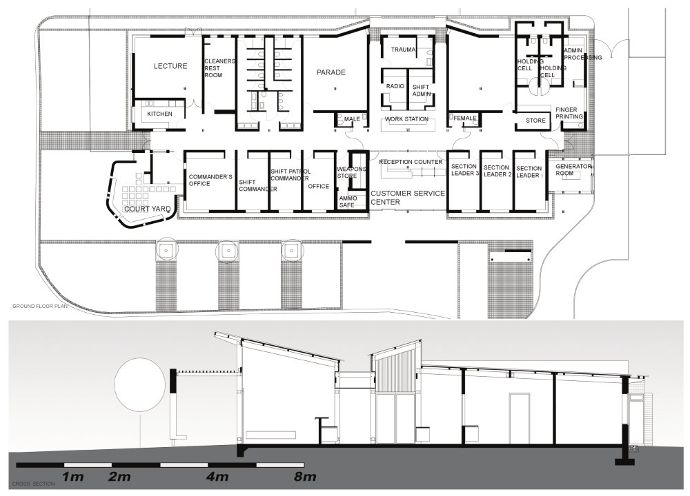
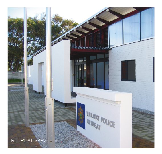
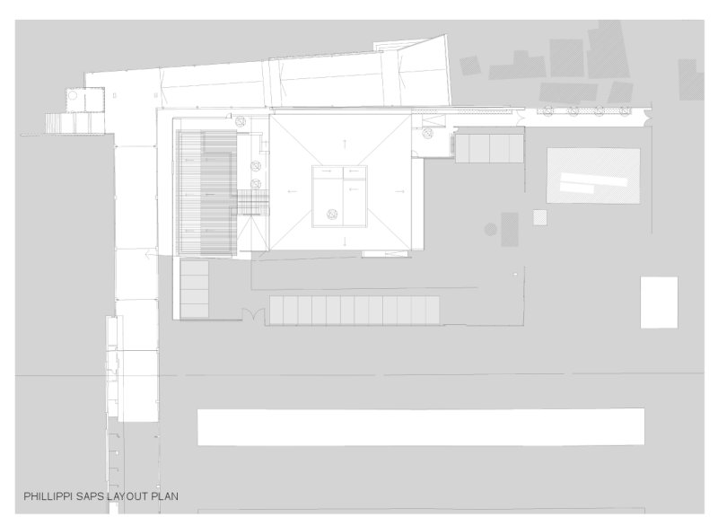
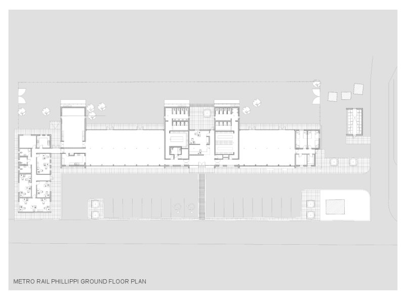
SAPS Retreat Railway Police Station
- click images to see larger version -
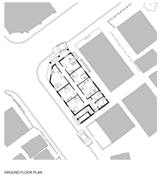
SAPS RETREAT RAILWAY POLICE STATION
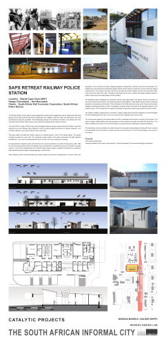
Location: Retreat Cape Town (2007)
Clients: South African Rail Commuter Corporation / South African Police Service
MOKENA MOKEKA / HOLGER DEPPE
MAKEKA DESIGN LAB
The Retreat Railway Police Station acknowledges that a better public engagement can be fostered by fashioning spaces and environments that promote transparency and visibility, which are open and welcoming, and most importantly are safe and accessible. The building plays its part in the narrative of a better, more efficient and more connected South African Police Service to be used and accessed by the citizens it serves.
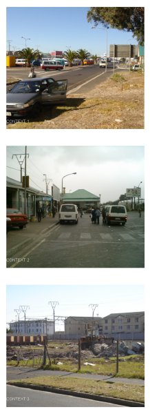
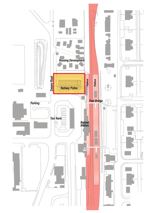
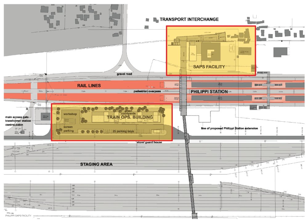
The client SARCC (today: PRASA) has chosen strategic locations at major junctions within the Western Cape Rail network for four new Railway Police Stations in order to improve safety and security for railway customers. One of these is Retreat, a low income suburb in the Cape Flats.
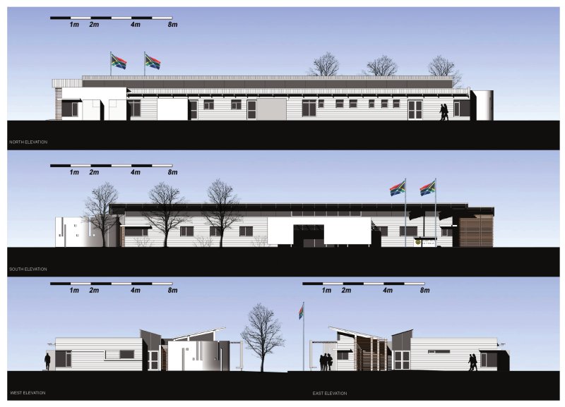
The police station provides the northern edge to an existing square in front of the railway station. The square is largely occupied by a taxi rank. The surrounds consist mostly of low scale commercial and light industrial development. Low income housing stretches from the other side of the railway line onwards.
During Apartheid, Institutions were entrenched for the use and protection of a limited minority group. After 1994 the country has been faced with the challenge of the reconstruction of institutions to serve the needs of a greater majority – such as the Constitutional Court. Retreat Police Station makes a valuable contribution to an approach that redefines the police station building typology of South Africa.
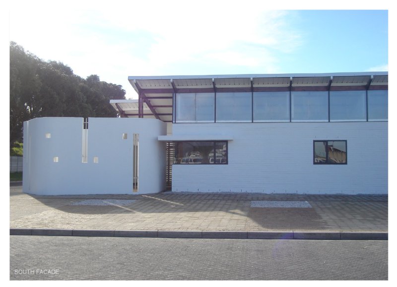
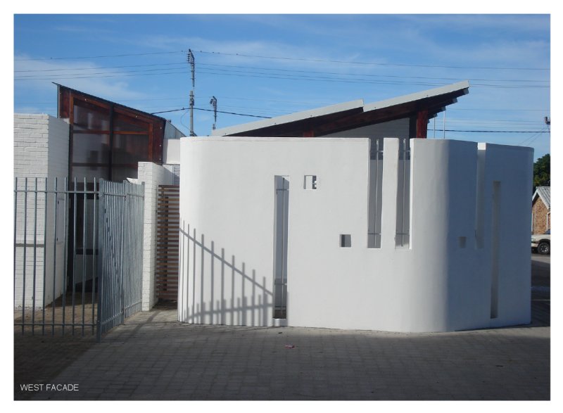
Police stations need to represent safety and security instead of the historic representation of a force of fear and oppression. This is achieved through a design language of transparency, identity of service and well-being. The building has a strong presence flanking the station square with its entrance marked by a screen wall and a glazed entrance foyer. The entrance and foyer with its service desk are directly visible to the taxi rank and other public zones and invite rather than repel. Through its openness and choice of material the design response fosters a sense of pride and encourages dignity and self respect.
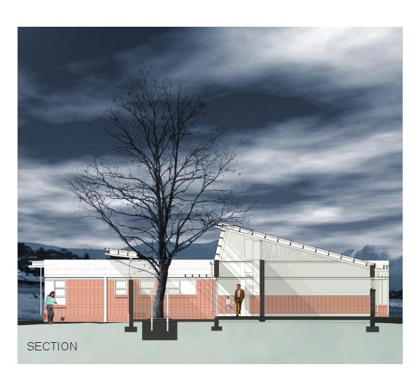
The building’s simple rectangular form provides a strong, well-scaled edge to the square while the articulation of its ends provides formal interest. The building achieved a high degree in cost effectiveness through a minimalist approach to construction and material. This is reflected in the timber structure under use of SA pine and carefully designed connecting elements in steel. A transparent multiwall product was used for all clerestory glazing. From inside the foyer, SAPS operations are visible and sensible through the lowered screen behind the service desk.
The mystery of light is explored both in an effort to create a design that excites the imagination and that changed with the changing light of the day. It is a civic structure that is delicate at the human scale.
The environment created by this police station is that of openness and provision of service to the people. The sense of dignity reflects itself by the high acceptance of the building in the public and within the police force. The sense of identity and value of the work of the police is welcomed by the individuals working at this station.
The importance of rail as backbone of public transport for all people but specifically for those with lower incomes is emphasized by the provision of a safe and secure environment, for which this building is one piece in the puzzle.
Awards:
CIFA Award of Merit 2007 - Inaugural recipient of the Gold Loerie Award for Three Dimensional & Environmental Design-Architecture.
The Aesthetics of Safety

- click images to see larger version -
THE AESTHETICS OF SAFETY
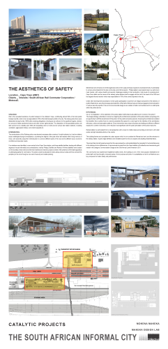
Location: Cape Town (2007)
Clients: Intersite / South African Rail Commuter Corporation / Metrorail.
SITUATION:
Rail is the accepted backbone of public transport in the Western Cape, contributing almost 59% of the total public transport profile, which in turn is responsible for 29% of the total transport profile in the city. The railway police force were disbanded during the late 1980’s after enduring allegations of acting as an enforcer for the apartheid regime, stricken by rumours of state sanctioned torture and other human rights abuses. The dissolution of this specialised police unit later proved to be a liability post 1994 with escalating crime on trains and at various train station stations, including vandalism, aggravated robbery, and violent assaults etc.
INTERVENTION:
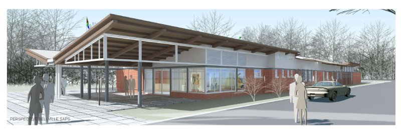
The reintroduction of the Railway police was deemed necessary after a series of brutal incidents, but had two distinct social challenges facing its renaissance; countering the stigma of the past which still resided within living memory of many, and secondly using their reintroduction to connect different parts of the city and its different socio economic conditions and peculiar needs.
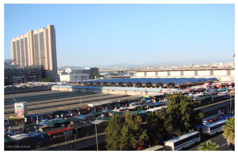
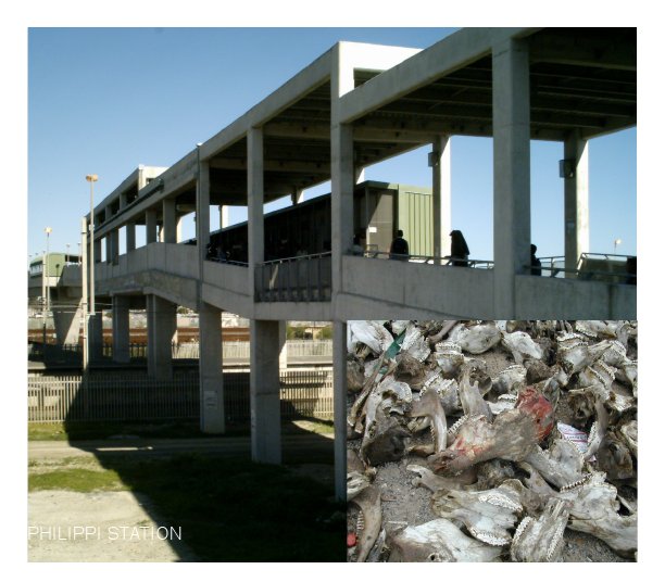
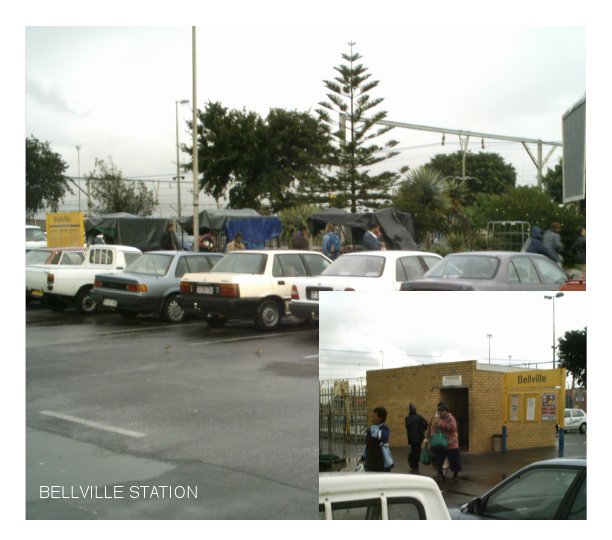
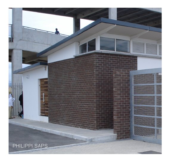
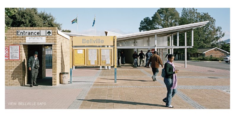
Four stations were identified, a new central hub at Cape Town station, and three satellite facilities, dealing with different degrees of social informality and contradictions, namely Philippi, Bellville and Retreat. All three satellites were located on the doorstep of taxi ranks and informal markets and meant to project a sense of the presence of the state apparatus in addressing safety for commuters. The police would be allocated to trains along various routes and thus connect the periphery to the core through a new web of security and visible policing.
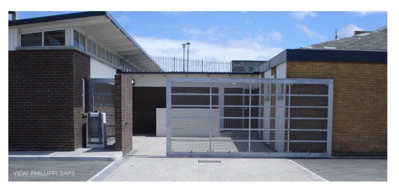
Bellville taxi rank remains one of the largest taxi ranks in the Cape peninsula exposed to increased levels of vulnerability to unrest, and protests from the taxi community, and informal sector. Philippi station was located close to a well known meat market, with various health and security challenges relating to food production, high levels of unemployment. Cape Town station as the nexus of the railway police stations had to engage with its role in the heart of the CBD and the largest informal market- which was responsible for 70% of the crimes reported in the city.
Unlike other development processes in which public participation would form an integral component of the delivery of public infrastructure, security processes precluded this. What rather followed was an intense engagement and education of various security experts in the art of environmental design as an enabler of safer communities and to re-instill pride within the police service.
- click images to see larger version -
HYPOTHESIS:
Can a ‘re-imagination,’ of the aesthetic of the police station shift behavioural patterns and ‘re-brand,’ the police? The design strategy undertaken involved re-imagining the architectural expression of the police station as typology into an opportunity to shift the social brand of the police; for the public and police persons. Ensuring the architecture heralded the transition from a police force to a service presented the space for a new logic for the interface of the architecture with place, culture and perception patterns. Every intervention was unique to its place and setting and offered a different exposure to context in all areas, crime reduction was significant and the public perception of the police improved.
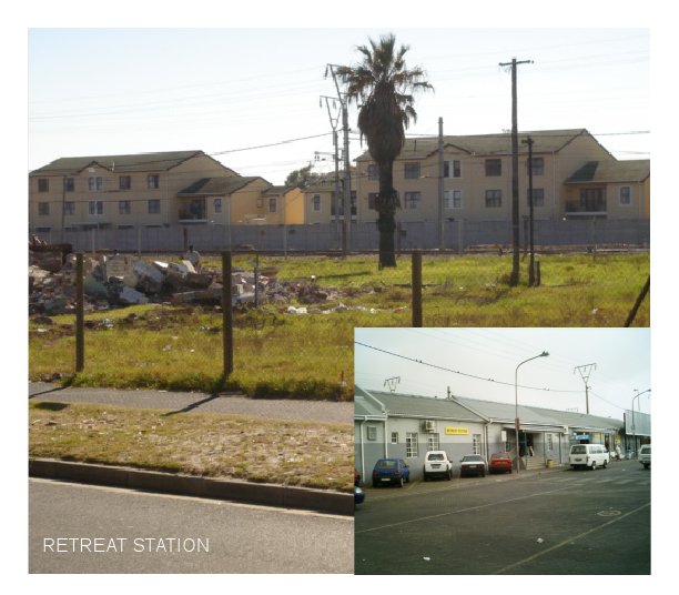
Retreat station is well located from a rail perspective with a lower to middle class surrounding environment, with retail center and light industrial activity in the vicinity.
The building frames and completes the urban square which in turn contains the Retreat taxi rank, and the entrance to the railway station. It gives edge definition and mediates scale from its civic aspect and abutting residential fabric.
The project has met with great success from the user perspective, and substantiates the necessity for humanist discourse in the making of civic infrastructure. It has received an award from the Cape Institute of Architecture and received a gold medal in the category Communication Design at the 33rd Annual Loerie Awards in 2011.
The community has experienced heightened safety levels, the building is one of the most popular destinations for police staff, and has brought a renewed sense of civic purpose and pride. It re-establishes a role for architecture as a key component of urban clarity and performance.
- click images to see larger version -
MOKENA MOKEKA / HOLGER DEPPE
MAKEKA DESIGN LAB
Urban Acupuncture - Khayelitsha
- click images to see larger version -
URBAN ACUPUNCTURE
‘The Needle and the (W)Hole.’
Location: Khayelitsha Cape Town (2007)
Design Consultants (phase two): City Think Space, ACG Architects and Development Planners
Clients: City of Cape Town and Khayelitsha community Trust
Khayelitsha is the largest and last township to be formally established in the Western Cape. Located at the heart of the Cape Flats and abutting Mitchel’s Plain, its narrative of dislocation, hope, and unequal access to resources, amenity and infrastructure positions the area as an exemplar of Apartheid informed informality. President Thabo Mbeki identified it as one of twenty national urban renewal nodes with a specific role to play in terms of social cohesion, upliftment and integration across the fractured cultural divide. The central business district was conceived to create a new urban room, an inspirational public realm for a devastated and desolate community lacking any resilient hierarchy of formalised ‘publicness.’
- click images to see larger version -
With competing voices of legitimacy, delivery of projects was hampered through indecision and lack of accountability between the state and social organisations. In a sense the informal landscape was mirrored by turbulent informal forces squabbling over the gaunt carcass of available resources. The noble intention of creating complementary CBD’s for each community (So called colored and Black African) has not been achieved despite the presence of catalytic interventions which anticipate and provoke the spontaneous creation of convivial environments through strategic urban design interventions. The informal condition in this instance could be described as a coded void or ‘hole,’ in the socio spatial geography of place.
Within this process, multi-purpose centers were identified as key urban markers for urban development, and encompass four components, a sports and recreation aspect, municipal offices and service point, heath and service clinic, and a library/arts and culture aspect. These later evolved into Thusong Service Centres.
- click images to see larger version -
As an outcome of a two year public participation process held by the City of Cape of Town to identify hierarchies of need for the community, the necessity for the sports component was identified as a priority and Makeka design Lab was commissioned to execute. The creation of a civic catalytic architecture in a context where the civic imperative is not a normative priority of the state presented challenges for officialdom, and the project seeks to relocate the discourse of architecture in informal conditions as part of a transformative act shaping township into town through bold design- architectural and urban. How does the needle stitch the (w)hole?
Urban Acupuncture - Khayelitsha (Panel 2)
URBAN ACUPUNCTURE
‘The Needle and the (W)Hole.’
Location: Khayelitsha Cape Town (2007)
Design Consultants (phase two): City Think Space, ACG Architects and Development Planners
Clients: City of Cape Town and Khayelitsha community Trust
The absence of any coherent and applicable urban design framework for the location of the buildings and its subsequent phases created the need to develop a self imposed conceptual urban design framework which would anchor the Architecture into a new public logic. Arising out of this commission, Makeka Design Lab was subsequently appointed by KCT to lead an interdisciplinary team to create an urban design framework which further addressed the imperatives of positive densification, alongside a mixed use urban identity with a renewed emphasis towards jobs creation, housing provision and an advanced understanding of sustainable human settlement.
The work identifies opportunities for sensitive infill, the exhibition reflects a participatory argument for presenting a vision for a community to aspire to. However patterns of institutional dysfunctional continue to constrain the process of becoming.
- click images to see larger version -
- click images to see larger version -
- click images to see larger version -
Back to Panel 1.
MOKENA MOKEKA / RIAAN STEENKAMP
MAKEKA DESIGN LAB
IN-SITU UPGRADING
Below is a brief excerpt from each of the projects in this category. Click on the links or image to see the full project panel details and illustrations.
Besters Camp
Exhibitor: Harber & Associates
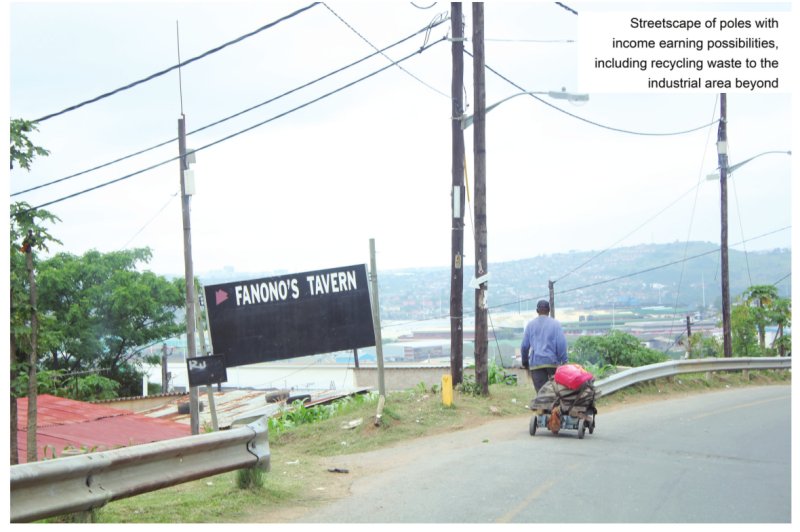
To appreciate ‘Bester’s Camp’ one has to revert back to the terrible race riots that erupted in Durban during January 1949. Africans and Indians were at loggerheads, mainly in Cato Manor, a mixed race, dense settlement of shacks behind Berea and only a few kilometres from the colonial CBD.
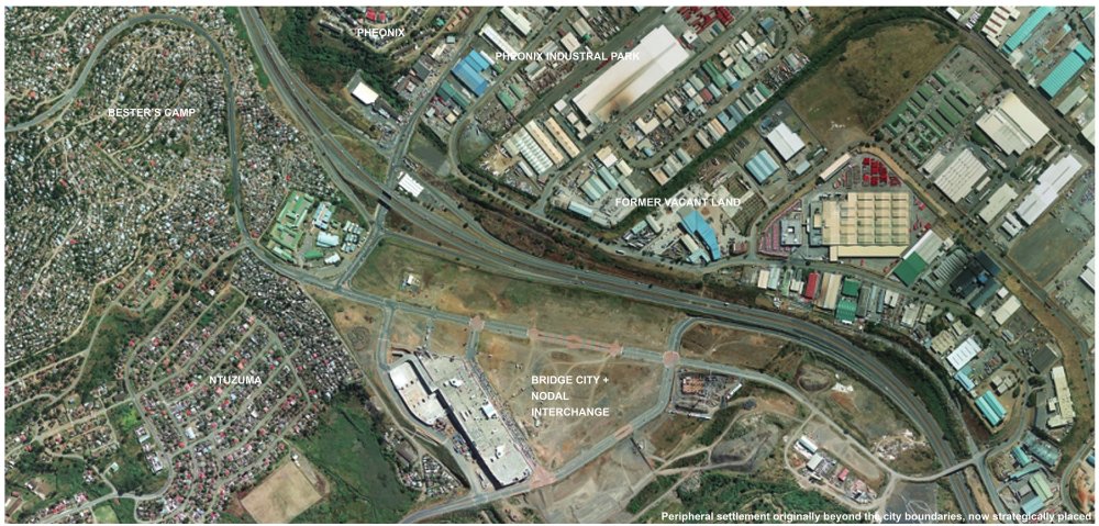
These upheavals gave the freshly installed National government a chance to systematically implement Apartheid planning. Africans were relocated to a new township, Kwa Mashu, to the north and Indians to Chatsworth in the south of the city. During the mid 70’s another Indian township, Phoenix was located further to the north. The wide space between these towns was left vacant, an empty condone sanitaire separating different race groups.
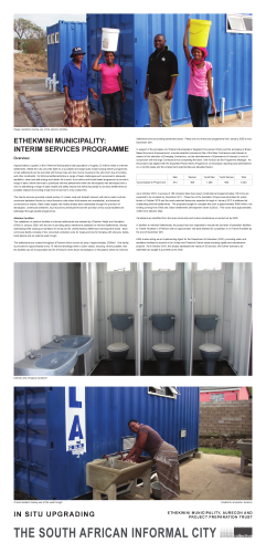
eThekwini Municipality: Interim Services Programme
Exhibitor: eThekwini Municipality, Aurecon and Project Preparation Trust
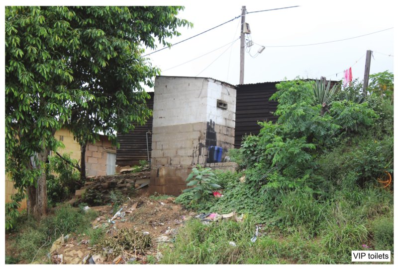
Approximately a quarter of the eThekwini Municipality’s total population of roughly 3.5 million reside in informal settlements. Whilst the City can pride itself on a successful and large scale mass housing delivery programme, not all settlements can be provided with full services and low income housing in the short term due to funding and other constraints. Yet informal settlements face a range of basic challenges such as access to adequate sanitation, clean and safe energy and roads. As a result, a pro-active and broad based programme to provide a range of basic interim services to prioritized informal settlements within the Municipality was developed with a view to addressing a range of basic health and safety issues and delivering rapidly to as many settlements as possible instead of providing a high level of service to only a select few.
Home Improvements
Exhibitor: Finmark Trust
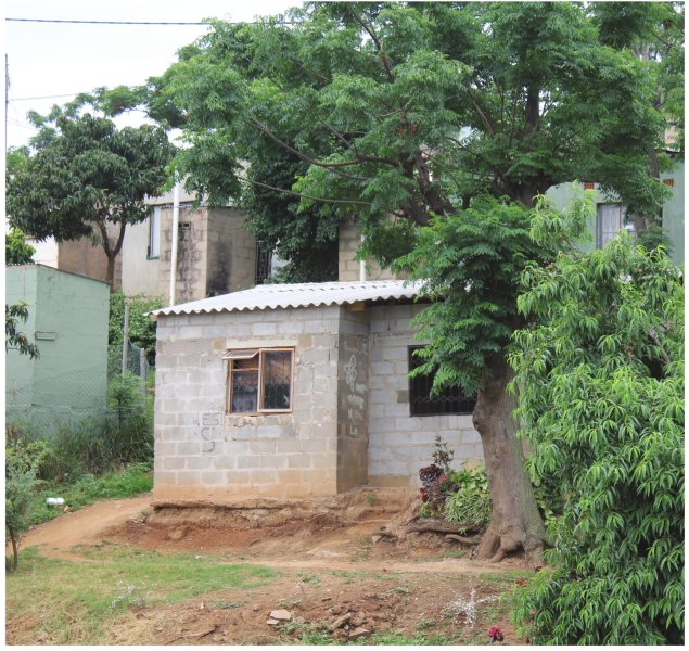
As soon as a subsidy beneficiary moves into their new house, thoughts turn to how to make it home. Cashbuild estimates that 60% of new units are upgraded within 18 months of the household moving in. In some cases, it’s a new window, or a fence; in others the entire house may be engulfed in a new structure. This building is incremental, step-by-step, financed with savings, microloans and sometimes even formal bank finance. In situ upgrading of the government subsidised house.
Kliptown Explored
Exhibitor: Monica Albonico and Lone Poulsen
Urban Design exists as the intersectional point between architecture , planning, urban geography, art and city management. Edgar Pieterse challenges urban practioners with the idea that, "a crucial focus of democratic practice should be spatially framed arguments for what the right to the city means".
In applying this concept and its relevance to the South African context, we argue that the commonality in terms of the language of urban design, must be able to be interpreted and understood by those who are engaging in the process. However, to add "quality to both process and producf, the outcomes, Pieterse indicates, has to "emerge out of a skillful articulation of urban struggles" for which "a broader repertoire of strategies and tactics are needed" that are unique to context and place. It is thus in our interest to explore and unpack the techniques and methodologies that make urban design a more relevant practice to unleash the potential benefits of urbanity.
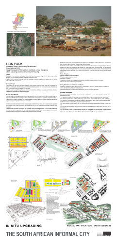
Lion Park
Exhibitor: Michael Hart Architects Urban Designers
The location of the site is within the Municipal District of the City of Johannesburg (Region Al. The site is situated north of Randburg and approximately 40 km North West of the Johannesburg CBD. The site is 39 Ha in extent and is bounded by the K29, Malibongwe Drive to the west, the N14 Freeway 10 the north, the R28 to the south and 6th road to the east.
Bester's Camp
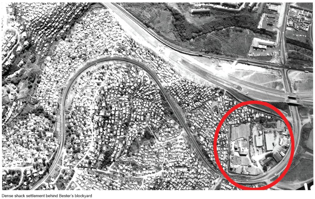
BESTER'S CAMP
eThekwini | 1990-current
Harber Masson & Associates
The Urban Foundation | Durban City Council
ORIGINS
To appreciate ‘Bester’s Camp’ one has to revert back to the terrible race riots that erupted in Durban during January 1949. Africans and Indians were at loggerheads, mainly in Cato Manor, a mixed race, dense settlement of shacks behind Berea and only a few kilometres from the colonial CBD.
These upheavals gave the freshly installed National government a chance to systematically implement Apartheid planning. Africans were relocated to a new township, Kwa Mashu, to the north and Indians to Chatsworth in the south of the city. During the mid 70’s another Indian township, Phoenix was located further to the north. The wide space between these towns was left vacant, an empty condone sanitaire separating different race groups.
A Pretoria based construction company, Bester Construction, were the main contractors for Phoenix. They set up a blockyard on this vacant land, on the city boundary. As the spatial control of Apartheid began to diminish in the 80’s the steep hillside behind became settled by a dense informal settlement of makeshift shacks known as ’Bester’s Camp’.
This is an account of how a problem has been transformed into an opportunity!
TAKING STOCK
The Informal Settlement Division of the Urban Foundation was encouraged by the Durban City Council to resolve the situation during the late 80’s. Harber Masson and Associates were commissioned to unravel the situation. In total contrast to contemporary township delivery with their modernist approach, focussed on delivery at volume, efficiency and minimal liaison with the future inhabitants, Bester’s Camp involved an on-going negotiation with residents that were already established, right on the edge of the city. Residents valued the advantage of being relatively well located on a springboard into the controlled city. To insert services it was initially recommended that ten per cent of the houses would have to be relocated elsewhere. They refused.
This presented an enormous challenge. The high densities and lack of adequate funding meant that an incremental approach had to be taken – a process and not a product. In-situ upgrading was the only viable approach. To convey this approach, large models were made to demonstrate the process, to demonstrate commitment and to engender communal ‘ownership’ of the proposal. The first entitled ‘NOW’ accurately recorded the existing situation on a large portion of the site to the extent that residents could identify their shelters. The next titled ‘SOON’ illustrated the ‘quick wins’ or envisaged short term interventions to consolidate the situation – public water kiosks, roadways, hardening of paths, steps and especially the storm water drainage lines. The final model ’EVENTUALLY’ illustrated a dense, multi storey settlement on steep cross falls to provide a vision of the future. Amalfi in Italy was provided as precedent!
The next step was to undertake a detailed survey of a sample of about seven per cent of the stock of informal structures to reveal prevalent problems and opportunities in the construction and to document how these may have been resolved within local cost and availability constraints.
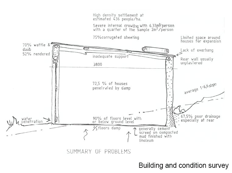
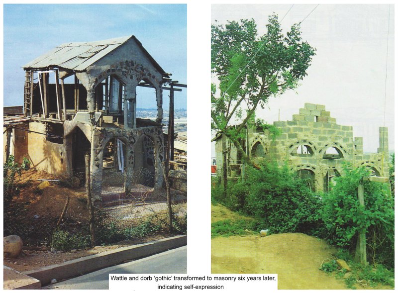
Inappropriate detailing causing damp in mud walls was the most serious shortcoming. Guidelines were issued on the importance of overhangs, raising the internal floor level and digging away the rear banks, all gleaned for excellent local examples of tyre retaining walls, use of vegetation to stabilise banks, recycled components such as windows and various shuttering systems to form walls filled with inorganic waste. Jap panels, the local name for the plywood sides to crates from the Toyota assembly plant, were particularly revealing. Double storey houses were recorded built entirely of these, including the roofing. Here an acute awareness of the properties of materials was evident because plastic sheeting was draped over the top with a final sacrificial layer of Jap panels to protect it from deterioration from the sunlight.
It is remarkable how informative indigenous solutions can be. To this day Harber’s home in Durban has ceilings of Jap panels, recycled waste, at a fraction of the cost of a conventional solution.
Continued on Panel 2
.
RODNEY HARBER
Bester's Camp (Panel 2)
Another component of this detailed investigation was to measure up all the building stock on one hectare ofland including the interior living arrangements. It was revealed that 28% of the land was already built on, very high for a relatively steep site and particularly high for a layout composing freestanding units. The average site size was only 104sqm!
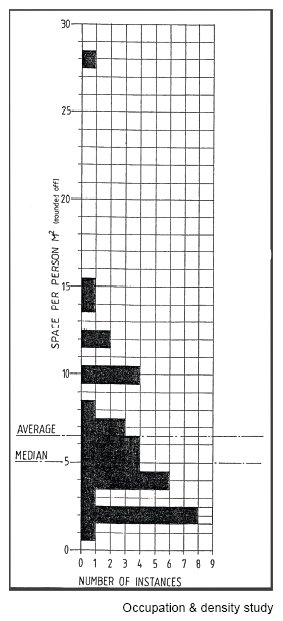
Occupational density, the total area of habitable rooms/occupants is a keen indicator of overcrowding. Here it proved to be dangerously high at 6.33sqm per resident. Five square metres is generally accepted as the minimum but in this sample the lower quarter averaged 2sqm per person or less - little more than a bed - with the severest case at 1.3sqm. At this level it implied that all floors were covered by bedrolls at night with minimal privacy. The average shelter had six residents and 2.5 habitable rooms. Many rooms were very simply curtained for further privacy.
Interpolating these figures revealed a very high density of 436 people per hectare and a total population of up to 35000 residents. Importantly, pedestrian access was also an accepted norm.
CONSOLIDATION
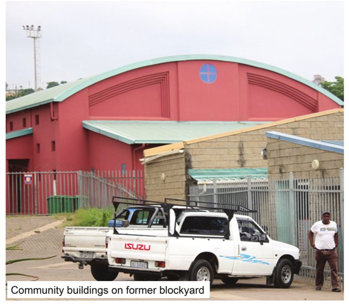
By then , the block yard had ceased to exist, leaving a well secured vacant site for the city to acquire communal buildings. This presented a golden opportunity, and the space eventually housed central offices , a hall, library, primary school, market stalls and service depots. The Urban Foundation established offices there as well.
All sites were pegged and surveyed after a drawn out and laborious process of initially placing wooden pegs on all corners after mutual agreement be all neighbours, generally after office hours. This process sent a signal of potential security of tenure which resulted in a flurry of upgrading by residents themselves. Hygiene was an important consideration at such high densities. Since water still had 10 be carried to each site , waste water was generally spread onto the vegetation. Initially every site had a masonry, ventilated pit latrine built on the edge and lined up wherever possible for subsequent pipelines. Electricity was supplied via prepaid meters, from a forest of overhead wires on poles that generally also served as street lighting. This all brought about a profound transformation in living conditions.
THE BUILDING PROGRAMME
Funding eventually became available for each resident to have the equivalent of a 16sqm masonry room built onto their existing house or as a freestanding unit. The Urban Foundation devised a computer programme consisting of the names of approved beneficiaries and the subsidy amount credited to them. Thereafter local hardware shops tendered to provide packages of basic materials and to deliver them as close to sites as possible when called for. They had to allow for five such deliveries to each site. The materials would then be paid for monthly from the central fund and the allocation of each beneficiary reduced .
This unleashed a flurry of construction by local contractors who had their labour costs settled at agreed rates based on output. Owners could also draw down their allocation with materials to improve existing houses. Numerous 'building inspectors' were available to approve proposals in situ, offer advice and to approve payments. Once again this was a drawn out process which maximised possibilities of individuality, treating each beneficiary and site as a unique element.
LESSONS LEARNT
Due to community involvement, Bester's is a high density settlement with mainly pedestrian access, situated near a variety of public transportation links and, most importantly, is visually stimulating due to the variety of building solutions - with most of the elevations being visible due to the steep terrain. Sub-tropical vegetation also unifies the vista and consolidates the soil.
All this results from IN-SITU UPGRADING, a people-centred approach which searches for, and responds to , the unique characteristics of every site.
Two decades ago there were half a dozen housing delivery methods to respond to. Now we simply have RDP layouts and some social housing from the public domain. The reasons are clear compared to the Modernist paradigm which has subsequently gripped our housing delivery in South Africa. Straight lines, identical delivery at volume, full services, overall control , annual budgets and, ultimately, dissipated responsibilities. The model is Service, Build then Occupy.
This is inverted in In-situ Upgrading. To Occupy is paramount - inevitably in a good location. As security of tenure is perceived, the Build consolidation phase ensues followed by Service. Instant shelter! Consider the advantages of the building process alone. Dozens of small time , labour-only contractors have been set up and continue to operate in the surrounding areas.
Housing authorities shy away from this people centred approach because it is drawn out and never has a fixed exit date. Budgets are perceived to be problematic and it also involves tedious community involvement, after office hours! Grand control appears to be relinquished!
Back to Panel 1
.
RODNEY HARBER
Home Improvements
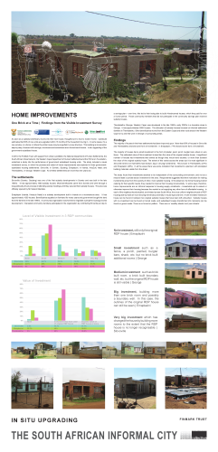
HOME IMPROVEMENTS
One Brick at a Time | Findings from the Visible Investment Survey
Finmark Trust
As soon as a subsidy beneficiary moves into their new house, thoughts turn to how to make it home. Cashbuild estimates that 60% of new units are upgraded within 18 months of the household moving in. In some cases, it’s a new window, or a fence; in others the entire house may be engulfed in a new structure. This building is incremental, step-by-step, financed with savings, microloans and sometimes even formal bank finance. In situ upgrading of the government subsidised house.
In 2010, the FinMark Trust, with support from Urban LandMark, the National Department of Human Settlements, the South African Cities Network, the Western Cape Department of Human Settlements and the FB Heron Foundation, undertook a study into the performance of government subsidised housing units. The study included a visual investment survey, in which the process and extent of home improvements was explored in three governmentsubsidised housing settlements: Slovoville, in Soweto, Gauteng; Emaplazini, in Inanda, KwaZulu Natal; and Thembalethu, in George, Western Cape. All of these settlements are more than ten years old.
The settlements
Slovoville (Soweto, Gauteng) was one of the first subsidy developments in Soweto and was built in the late 1990’s. It has approximately 1600 subsidy houses. Most beneficiaries came from Soweto and went through a long politically driven process of attending weekly meetings until they secured their subsidy houses. The area was officially opened by Mr Nelson Mandela.
Emaplazini (Inanda, Kwazulu Natal) is a subsidy development built in Inanda on a mountainous area. It has approximately 1000 houses. Beneficiaries squatted on farmland for many years and government bought the land from the farmers in the late 1990’s. A community organization was formed to negotiate a people’s housing process development. Interested community members participated in the organization by contributing 50 cents per day to a savings plan – over time, this led to their being able to build 4-bedroomed houses, which they paid for over a 5-year period. Those community members that did not participate in the community savings plan received subsidy houses.
Thembalethu (George, Western Cape) was developed in the late 1990’s, early 2000’s in a township close to George. It has approximately 5000 houses. The allocation of subsidy houses focused on informal settlement dwellers in Thembalethu. Other beneficiaries moved from the Eastern Cape and other rural areas in the Western Cape to try and find work in George or surrounding areas.
Findings
The majority of houses in the three settlements had been improved upon. More than 95% of houses in Slovoville and Thembalethu showed some form of investment. In Emaplazini, 77% showed some form of investment.
The majority of houses had a small investment in the form of plaster, paint, porch, burglar bars, shack or wire fence. The estimated value of this investment is less than the value of the original subsidy house. A significant number of houses had investments that looked as though they would have doubled, or more than doubled the value of the original subsidy house. The extent of this varied across the areas but it is most significant in Slovoville where over half (52%) had medium, big or very big investments. This is lower in Thembalethu (27%) and Emaplazini (28%). In all the areas there was some indication that investment is planned, with stockpiled building materials visible from the street.
The study found that investments seemed to be independent of the surrounding environment, and not as a result of state or private sector investment in the area. Respondents suggested that their motivation for making investments arose from the scarcity of other, more suitable housing. In the absence of a formal housing market catering for their specific needs, they needed to improve their housing incrementally. In some ways, therefore, home improvements are an informal response to housing supply constraints – households opt to extend or otherwise improve their housing because the market is not supplying any other form of affordable housing. In each of the neighbourhoods studied, and indeed across South Africa, the once uniform neighbourhoods of RDP housing side-by-side are now showing tremendous diversity in house type and form. A well-invested 4-bedroom house can be found in between two original subsidy houses that have been left untouched. Subsidy houses with no investment can be found on tarred roads, and subsidised houses transformed into mansions can be found on gravel roads. There is no format or pattern. There are no ‘wealthy streets’ and ‘poor streets’.
Continued on Panel 2
.
FINMARK TRUST
Home Improvements (Panel 2)

Case study | The joy of investing into a subsidy house
Jeanette and her husband Lumic relocated from Graff Reinet to George in 1992 searching for better job prospects. In 1979 Lumic put his name on a housing list for a site. In 1993 they moved onto their site, which had a toilet and built a 4-roomed bungalow made of wood planks to live in. There was no electricity supply or running water. Finally in 1995 they moved their bungalow to a different part of the property and for three weeks watched as their subsidy house was finally constructed. They received the Title Deed to their property a few months after the house was completed.
In 2010, Jeanette and Lumic decided to remodel and improve their house. They took two personal loans from Standard Bank and First National Bank for R30 000, and then used another R25 000 of their own savings to finance the construction. Lumic is a full time employee of the Coca-Cola Company; he needed his pay-slip, ID document and bank statements to acquire the loan. Jeanette is a member of a stokvel. Although the building materials were bought incrementally, the remodeling of the house was completed in three weeks during February 2010.
The current house will be inherited by their youngest son thus they will never consider selling the house. The son currently occupies the original wooden bungalow they lived in before their subsidy house was built. As a family, they enjoy the freedom and independence that comes with being homeowners.
Case study | The story of a 35m2 starter house
The respondent we interview describes herself as a woman who has more faith in the dreams she has in the daytime. “You can’t trust the dreams you have at night when you are sleeping”.
There is no telling what her dreams were when she went to write her name on the housing waiting list or when, at the community meetings, the older men teased her suggesting she was too young to own a house thus would not qualify. However, regardless of her youthful looks, she was a single mother earning less than R 3500 per month and qualified to be among the first (along with the elderly) to be allocated a new home. Now her property boasts the original subsidised house, a container from which she runs a spaza shop, and two formally built backyard rooms, all with formal ablutions.
Patience moved to Slovoville in 1997. However, for nine years she continued to work in Silvertown faithfully making the commute each day. She also sold sweets during this time using the additional income to supplement the extra transportation costs that accompanied the move to her new RDP home. An inspiring story unfolds to reveal sheer determination, strength of character and hard work.
The rooms and spaza shop are both projects that were completed incrementally and yet they both grew simultaneously alongside the other. The rooms, needing much more capital than the spaza, and were built with a combination of stokvel savings, micro loans, building materials from Builder’s Warehouse and leaps of faith. The rental she received allowed her to take on an additional micro loan to build up her business and buy stock for the spaza shop. And the green container, on the other hand, is what she used to turn it into a spaza shop and sell small grocery items to her neighbours. She sees herself as having no other option in pursuing this avenue because she fears she will not find a job elsewhere. She hopes her efforts will leave an indelible impression on her daughters.
Today she is well respected among her peers, family and neighbours and especially her customers- the children who come and buy from her spaza shop. Her entrepreneurial spirit is inspiring. It has led her to take on financial risk with the micro loans she has acquired to establish a spaza shop and built the backyard rooms, which now house two tenants.
“An RDP house gives you the opportunity to use your mind and brains to make decisions for you and your family.”
“It is a shelter that gives you space to think and freedom to plan the future.”
“It is a start. It is one small thing, but this thing I like very much.”
Back to Panel 1
.
FINMARK TRUST
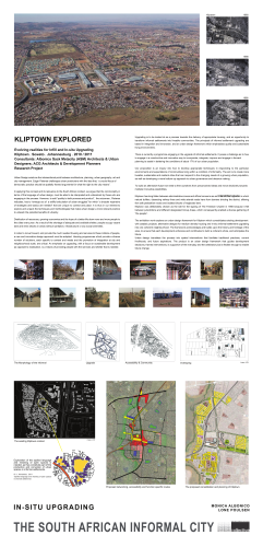
Kliptown Explored
KLIPTOWN EXPLORED
Evolving realities for Infill and In-situ Upgrading Kliptown . Soweto . Johannesburg. 2010 I 2011
Consultants: Albonico Sack Metacity (ASM) Architects & Urban Designers; ACG Architects & Development Planners
Research Project
Urban Design exists as the intersectional point between architecture , planning, urban geography, art and city management. Edgar Pieterse challenges urban practioners with the idea that, "a crucial focus of democratic practice should be spatially framed arguments for what the right to the city means".
In applying this concept and its relevance to the South African context, we argue that the commonality in terms of the language of urban design, must be able to be interpreted and understood by those who are engaging in the process. However, to add "quality to both process and producf, the outcomes, Pieterse indicates, has to "emerge out of a skillful articulation of urban struggles" for which "a broader repertoire of strategies and tactics are needed" that are unique to context and place. It is thus in our interest to explore and unpack the techniques and methodologies that make urban design a more relevant practice to unleash the potential benefits of urbanity.
Distribution of resources, growing economies and the hope of a better life draw more and more people to the cities every year. As a result of the shortage of adequate and available shelter, people occupy vacant land and erect shacks in areas without sanitation, infrastructure or any social amenities. In order to move forward , and provide the much needed housing and services to these millions of people, a new and innovative design approach must be adopted. Housing programmes which provide a diverse number of solutions, each specific to context and needs and the promotion of integration at city and neighbourhood scale, are critical. An emphasis on upgrading, with a focus on sustainable development as opposed to eradication, is a means of providing people with the services and shelter that is needed.
Upgrading is to be looked at as a process towards the delivery of appropriate housing, and an opportunity to transform informal settlements into liveable communities. The principals of informal settlement upgrading are based in integration and innovation, and an urban design framework which emphasises quality and sustainable living environments.
There is currently a programme engaging in the upgrade of informal settlements. It poses a challenge as to how to engage in a constructive and innovative way to incorporate , integrate, improve and engage in forward planning to assist in bettering the conditions of about 17% of our urban population.
Our proposition is an inquiry into how to develop appropriate techniques in responding to the particular environments and expectations of communities living within a condition of informality. The aim is to create more liveable , sustainable and resilient cities that can respond to the changing needs of a growing urban population, as well as developing a more bottom-up approach to urban governance and decision making.
To build an alternative future we need to free ourselves from preconceived ideas and move decisively towards multiple innovative possibilities.
Kliptown has long fallen between administrative zones and official concerns as an interstitial space in which natural buffers, dissecting railway lines and wide arterial roads have form barriers dividing the district, offering few safe pedestrian routes and isolated blocks of neglected land.
Kliptown was deliberately chosen as the site for the signing of The Freedom Charter in 1956 because it fell between jurisdictions and different designated Group Areas, which consequently enabled a diverse gathering of "the people”.
The exhibition work explores an urban design framework for Kliptown which consolidates existing development with catalytic projects, alternative designs for medium density housing and in-situ informal settlement upgrading into one coherent neighbourhood. The framework acknowledges and builds upon the history and heritage of the area, to ensure that each development enhances and contributes to build a coherent whole , and anticipates the future.
Urban design translates the process into spatial interventions that facilitate traditional practices, current livelihoods, and future aspirations. The product is an urban design framework that guides development decisions, frames interventions, is supportive of the everyday and the celebratory but is flexible enough to enable future change.
Continued on Panel 2
.
MONICA ALBONICO AND LONE POULSEN
Kliptown Explored (Panel 2)
KLIPTOWN EXPLORED
Working towards Integrated Human Settlement Upgrade Kliptown . Soweto . Johannesburg . 2009 I 2010
Consultants: Urban Dynamics, Albonico Sack Metacity (ASM) Architects & Urban Designers, with Cohen Judin Architects
Funders: Urban Dynamics I CoJ Housing Department (JDA)t
The Urban Design Framework and development guidelines produced by the architectural and urban design team coordinated by Urban Dynamics, developed a programme for the total upgrading of the greater Kliptown area. The approach was to produce an integrated turnkey strategy per precinct to inform the formulation of the business plan for the consolidation and upgrading of the area. The aim was to provide a planned guide to the housing delivery process, fully utilise the in-fill potential of available plots around the heritage housing stock, expand the range of low-rise medium density housing options , offer mixed-use opportunities where possible, and through an incremental process, consolidate the area by providing adequate new accommodation for all.
In recognizing the complex network of social relationships and urban responses that have developed in this constrained environment, the urban interventions proposed by the framework are intended to patch up together these fragile urban living patterns. Integration will take place through a series of components and bring together under-utilised local schools and threatened commercial strips, with local extended pedestrian routes, civic squares and public facilities. The elements bringing the different precincts together are the pedestrian ribbon , new and improved bridges and a system of squares and places for social and economic interaction, and the creation of a new housing pattern which is weaved into the existing landscape- a patchwork with overlapping strips, and seams of connectivity across it's previously frayed edges.
Urban Design Principles
The framework promotes: Compact urban living + varied & site specific housing typologies + the use of shared/communal spaces + the introduction of landscaping & productive gardens.
Urban Design Framework & Housing Typologies Development
Housing typology studies were carried out by six architectural firms working in collaboration 10 provide housing types responding to the principles and objectives contained in the Urban Design Framework developed by ASMI Cohen & Judin.
The overriding urban design principles explored in the alternative typologies were:
- Encourage the development of mixed-use buildings along main movement routes.
- Introduce a range of housing solutions specific to individual needs.
- Improve the connectivity between precincts.
- Encourage the construction and upgrading of businesses along Union street and around the station.
The vision is the provision of appropriate housing and accessibility to the city for all the residents of Kliptown who are currently living in the informal settlements, while still retaining the socio-economic network through:
- Connectivity - Establish and reinforce multiple pedestrian connections.
- Sustainability - Economic and environmental
- Live-ability - Improvement of public and private environments.
The brief was to develop housing typologies for the specific designated precinct in Kliptown . The work was conducted in the form of 2 Charreltes where the initial conceptual proposals were then developed, costed and their viability tested.
The Architectural Practices initially prepared a conceptual response to the brief that included a precinct layout indicating block layouts, roads and site subdivisions to accommodate the proposed housing typologies. The brief did not include detailed financial costing or the necessary process of community participation and feedback..
The approach to this development is rooted in the belief that every neighbourhood is unique; culturally, socially and environmentally, and the housing programme must fit its context. The mass housing approach promulgated by the RDP programme is perpetuating the ineffectiveness of the already severely compromised urban system. It is therefore important that we begin to imagine new possibilities through direct engagement with the realities shaping people's lives, and accept that informality is "just a way" to access the opportunities of urban living.
Back to Panel 1
.
MONICA ALBONICO AND LONE POULSEN
Lion Park
- click images to see larger version -
LION PARK
Integrated Mixed-Use Housing Development, Johannesburg 2009
Design Consultant: Michael Hart Architects . Urban Designers
Client: Gauteng Local Government and Housing
Locality
The location of the site is within the Municipal District of the City of Johannesburg (Region Al. The site is situated north of Randburg and approximately 40 km North West of the Johannesburg CBD. The site is 39 Ha in extent and is bounded by the K29, Malibongwe Drive to the west, the N14 Freeway 10 the north, the R28 to the south and 6th road to the east.
Contextual Analysis
The people of Lion Park live a rural lifestyle. Makeshift shacks crammed orderly into urban blocks that are separated and shaped by eroded paths. Service infrastructure is limited 10 ventilated pit latrines and shared water sources. Residents currently grow a limited amount of vegetables and herd cattle. In order to Cleate meaningful change the urban environment must facilitate for lifestyle change, access to facilities, infrastructure, economic development and healthy environments.
An Urban Design Approach
The Urban Design methodology proposes a multi-pronged approach where the Social, Economic, Environmental , Design and Engineering (SEEDE) criteria are managed within a parallel process of analysis, review, consultation , and implementation. The outcome is to create an Integrated City. This is fundamental in achieving the aims of rectifying the inefficiencies that have plagued housing developments for low income communities.
- click image to see larger version -
Identified communities shall benefit from the social and public investment through being able to access economic opportunities. This shall enable mixed-use residential districts to develop over time into socially and economically sustainable neighbourhoods.
The development shall create environments that are liveable, vibrant, secure and affordable. Lion Park shall create access for private and public transportation with comfortable, safe pedestrian routes. The development approach favours public transportation and non-motorised transport as opposed to a vehicle-based approach .
The framework strives for an Integrated Compact City form that will enhance positive public spaces, essential services including; health , education, emergency services and safety.
Residential densities shall be achieved through the implementation of a variety of housing typologies. These typologies shall take into consideration the mobile and incremental nature of communities. The demographic make-up of new and existing families moving into urban areas will present differing needs. Family size and levels of affordability shall be catered for within various forms of tenure. This may require the need for a flexible design approach.
Points of Departure
- Common agreement in decision making
- Principles to guide decision making
- Statement of priorities
- Programme of design, planning, approvals, specialist studies and implementation and phasing
- Channels of communication and Accountability
- click images to see larger version -
Poverty Alleviation and Sustainable Livelihoods
The task of developing physical frameworks as a methodology to improving lifestyles requires a strategy for poverty alleviation through economic development. The methodology shall include education and training , financial and social resources.
Economic Development
- Economic development of the local community must be assessed in terms of current economic activity , skills and entrepreneurship
- The inability to compete with the formal economy means that other forms of economies shall be identified.
- Lack of appropriate business faci lities. technology, communication and knowledge must be made available.
- The location of the development could offer competitive advantages of being located in close proximity to the Kya Sands Industrial node and the Lanseria Airport Development.
- The major transport arterials flank the site with direct access for passing trade and direct linkages to major centres.
- The proposed development will offer commercial, retail and trading facilities for traders within the formal and informal sectors.
- The opportunities of waste to energy business practices are available as start up businesses. (Waste collection and sorting, recycling, crafts, composting, urban agriculture and building material manufacture.)
Continued on Panel 2
.
MICHAEL HART ARCHITECTS URBAN DESIGNERS
Lion Park (Panel 2)
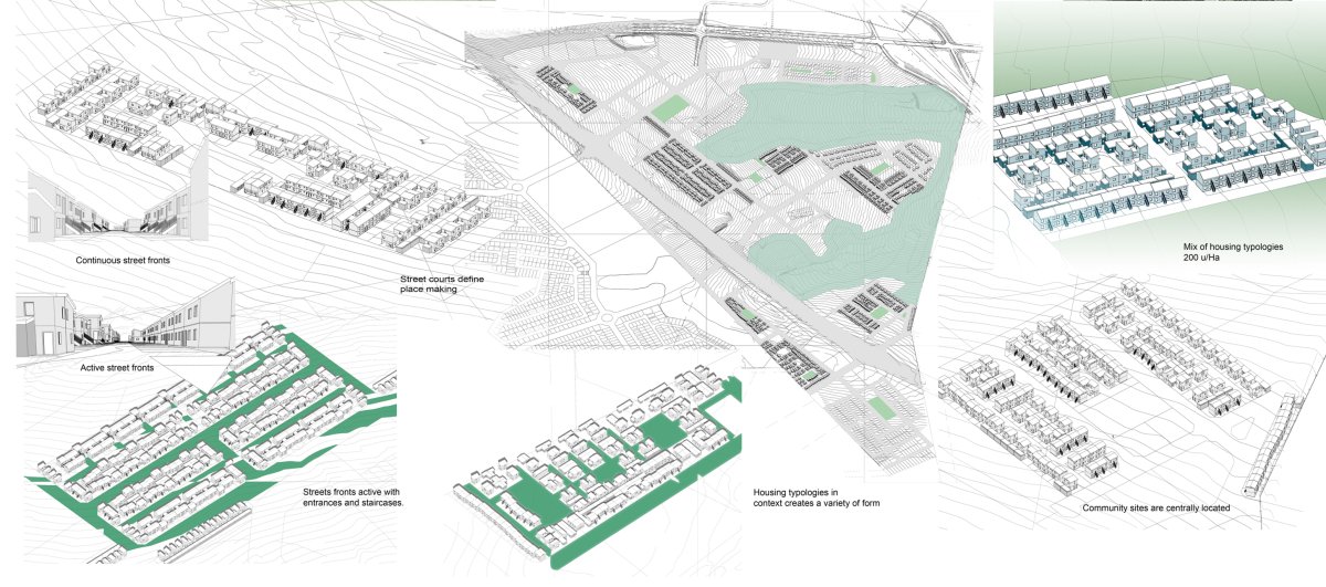
- click images to see larger version -
LION PARK
Integrated Mixed-Use Housing Development
Key Strategic Objectives:
Movement assessment: Access 10 and from the site is via the provincial network of Gauleng. Roads bounding the site are currently undergoing upgrade to cope with traffic flows.
Public Transportation (SRT) has no current implementation plans to the location of Lion Park.
Activity Spines: Access to economic development and a vibrant urban environment will necessitate for planned activity spines. The activity spines will create competitiveness between SSME's by facilitating access to premises, trading stalls, finance and support,Activity spines and related business opportunities shall be placed close 10 public transport hubs and link activity nodes.
Transport Orientated Development: Taxi ranks shall support mixed use centres and be located centrally to allow for ease of walking for commuters.
Pedestrian friendly environment: Precincts shall encourage pedestrian movement. High density low rise row housing grouped along narrow roads creates a sense of place within the public street. Public amenities and public open space within a core of RDP housing will offer ease of pedestrian access.
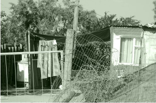
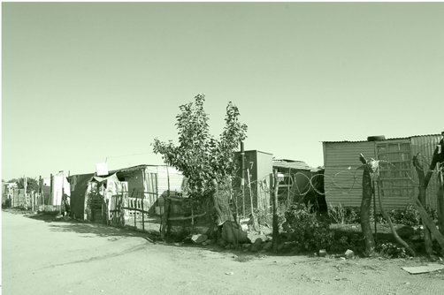
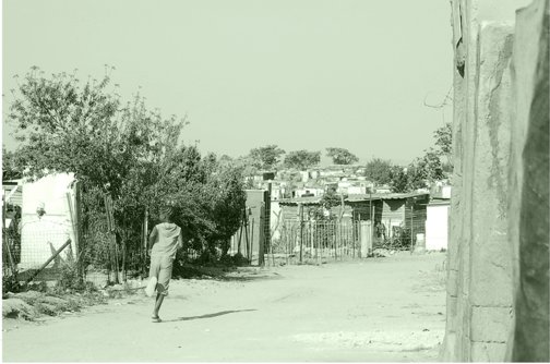
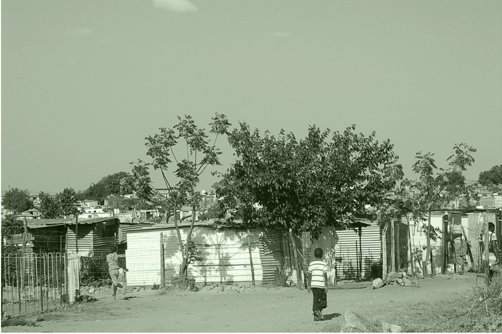
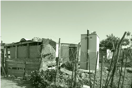
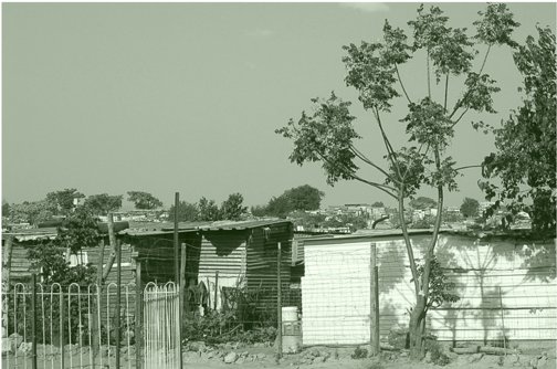
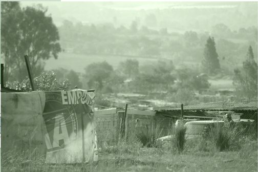
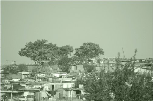
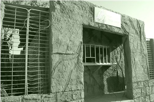
Design of Streets: The design of streets is seen as cri tical to the success of 'place making'. Streets within neighbourhoods of small houses become spaces for living. Social space for children to play and encourage interaction between neighbours. The pedestrian orientated roads open into public courts, parks and squares. The Woonerf concept of road ways shared with public active spaces adds variety and excitement to a backdrop of simple buildings. Building on corners emphasise the openings into streets with corners occupied by different uses such as a corner shop . Neighbourhood streets shall be planted with trees, defining edges and creating shaded canopies. Seating and threshold spaces off streets define privacy gradients into houses and public buildings.
Mixed-Use Nodes: It is envisioned that mixed use nodes become the core to each precinct. The civic node will include civic! municipal buildings, transport rank, public square, informal and formal trading with a residential component on first floor level.
Community nodes within the re sidential precincts will contain centrally placed parks that are defined with flanking social and community buildings with small convenient shopping. Parks will become shared with churches, clinics, community centres and row housing.Mixed uses encourage a work live environment encouraging convenient pedestrian movement between uses.
The dignity for low income communities to inhabit positive urban environments with safe well designed public space and amenities within the neighbourhood will ensure an ownership and pride of place.
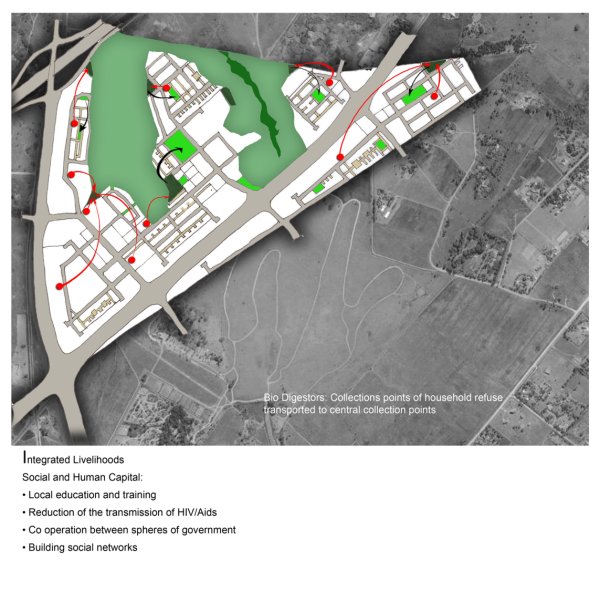
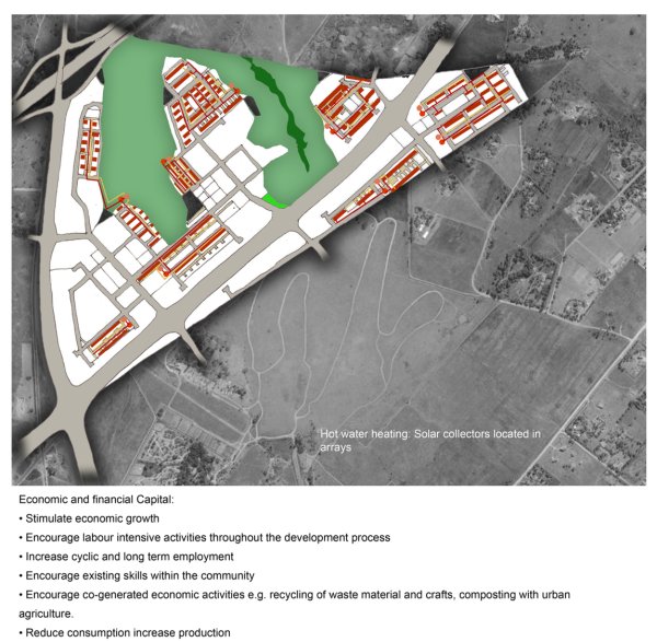

- click images to see larger version -
Urban Morphology
The proposed development is bounded by provincial roads to the west and the south. The existing wetlands to the north define the developments northern edge.
Natural features
The Ecological and Wetland Assessment encompasses the following: • Red Data Species evaluation;' Identification of all plant communities on site; • Site evaluation in terms of potential sensitive habitat; • Delineation of the wetland;
Challenges
To ensure that development takes place in an environmentally sustainable including that the basic environmental condition of the site are part of the development process.
Rehabilitation
Where informal housing infringes on the wetland area, this housing will have to be removed and the area will have to be rehabilitated to retain its wetland functionality.
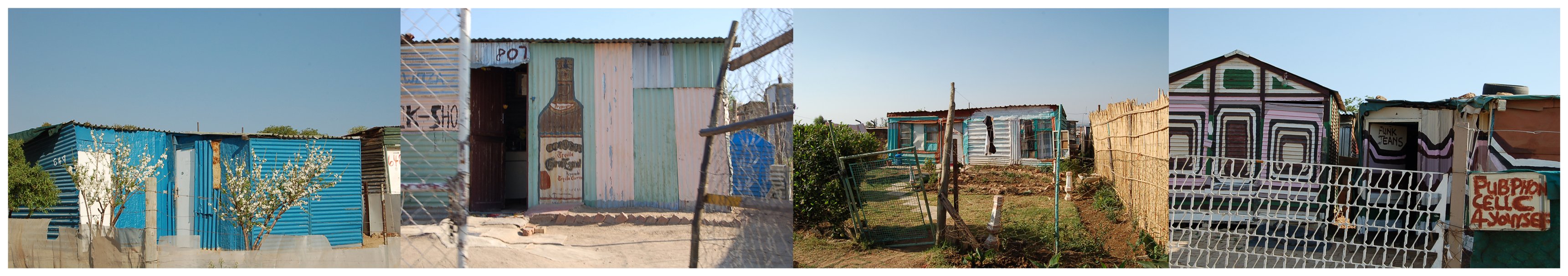
Accessibility
It is recommended that natural open areas be retained creating and protecting a public open space system, with corridors linking areas of natural vegetation to promote rehabilitation of natural vegetation and minimise further disturbance.
Safety
The open space system including the wellands needs to be safe for people to use. Visibility, surveilance and comunity policing of the open spaces will reduce criminal activity. Encourage activities to occur at the edges of the wetland to safe guard against desolation, dumping and detruction.
Diversity of adjoining uses
The possible use of the 30m buffer strip around the wetland should be used for activities such as playgrounds, sporting activities, cultural activities, and ecologically related activities such as bird hides and places of educational instruction.
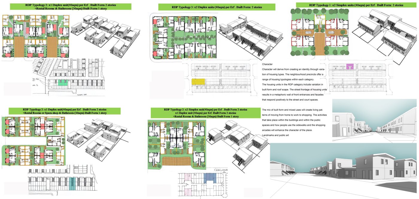
- click images to see larger version -
Connectivity
It is envisioned that raised timber boardwalks be installed in areas that encourage connection across parts of the wetland. This will ensure that the area is active and that ecological awareness is encouraged.
Ecological sustainability
The urban environment will be enhanced by this natural resource. Indigenous vegetation will attract bird life and
ensure protection for endangered species of grass and trees.
Back to Panel 1
.
MICHAEL HART ARCHITECTS URBAN DESIGNERS
eThekwini Municipality: Interim Services Programme
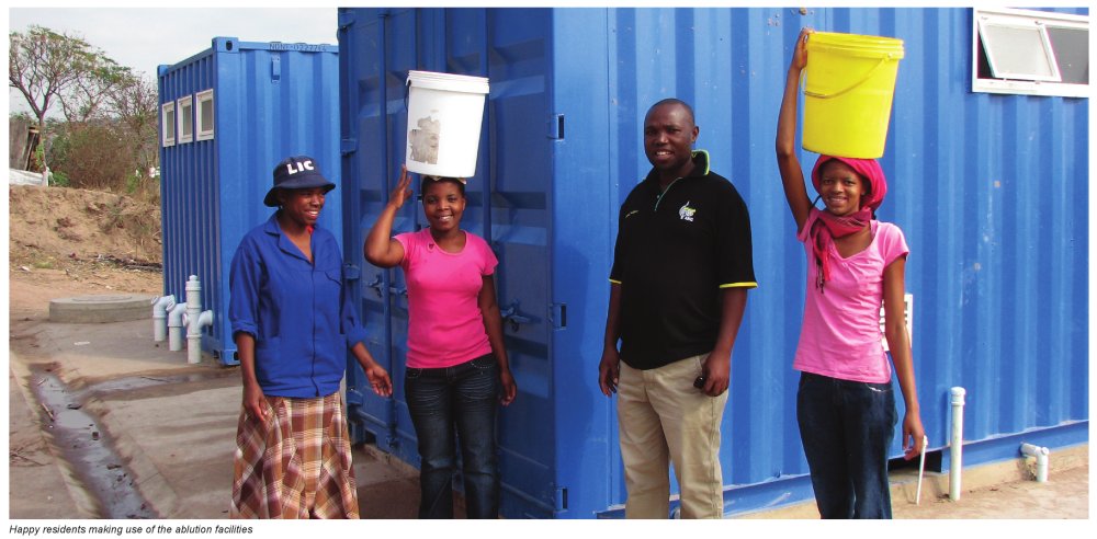
ETHEKWINI MUNICIPALITY: INTERIM SERVICES PROGRAMME
Overview
Approximately a quarter of the eThekwini Municipality’s total population of roughly 3.5 million reside in informal settlements. Whilst the City can pride itself on a successful and large scale mass housing delivery programme, not all settlements can be provided with full services and low income housing in the short term due to funding and other constraints. Yet informal settlements face a range of basic challenges such as access to adequate sanitation, clean and safe energy and roads. As a result, a pro-active and broad based programme to provide a range of basic interim services to prioritized informal settlements within the Municipality was developed with a view to addressing a range of basic health and safety issues and delivering rapidly to as many settlements as possible instead of providing a high level of service to only a select few.
The interim services provided consist mainly of: a basic road and footpath network with storm-water controls, communal sanitation blocks (or urine diversion units where bulk sewers are unavailable), and electrical connections to shacks. Basic water supply has mostly already been addressed through the provision of standpipes. Livelihoods initiatives, local economic development and the provision of key social facilities are addressed through parallel programmes.
Ablution Facilities
The installation of ablution facilities to informal settlements was initiated by eThekwini Water and Sanitation (EWS) in January 2009, with the aim of providing basic waterborne sanitation to Informal Settlements, thereby addressing EWS’ backlog of sanitation for all as per the United Nations’ Millennium Development Goals. Each communal facility consists of two converted containers (one for males and one for females with showers, toilets, hand-basins and an external wash trough.
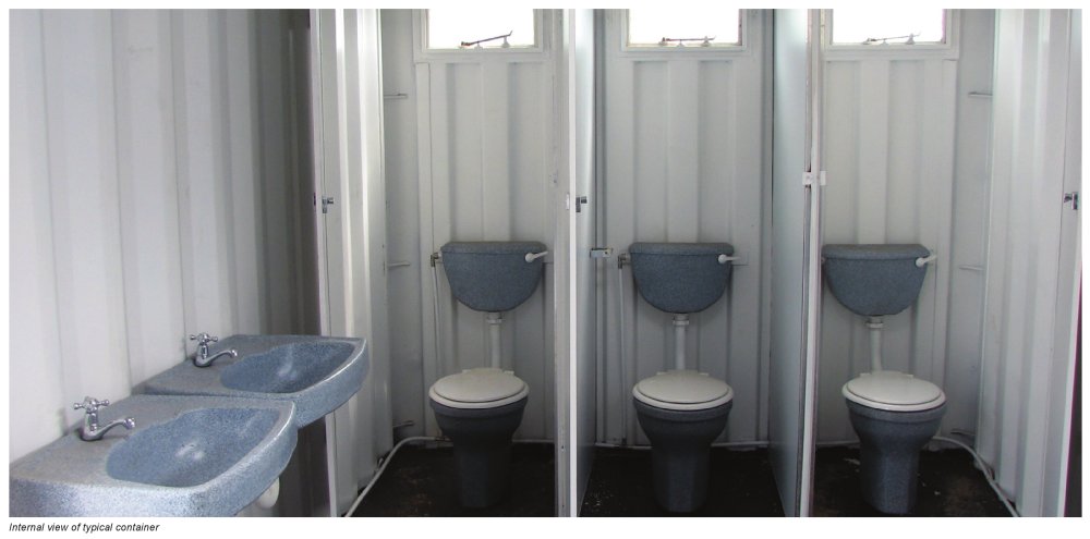
The settlements are located throughout eThekwini which covers an area of approximately 2300km2. One facility is provided for approximately every 75 informal dwellings within a 250m radius, ensuring, where possible, that the facilities can be incorporated into the eThekwini Unit’s future formalisation of reticulation within the InformalSettlement and surrounding catchment areas. Phase one is a three year programme from January 2009 to end December 2011.
In support of the principles of eThekwini Municipality’s Targeted Procurement Policy and the principles of Broad Based Economic Empowerment, a similar selection process to that of the Main Contractors was followed in respect of the selection of Emerging Contractors, via the advertisement of Expressions of Interest, to work in conjunction with the large Contractors thus completing the team, with Aurecon as the Programme Manager. As this project was aligned with the Expanded Public Works Programme, all necessary reporting was administered on a monthly basis and the employment opportunities are tabulated below:
| Men | Women | Youth Men | Youth Women | Total | |
| Accumulated to Project end | 912 | 306 | 1,480 | 506 | 3,204 |
As at October 2010, in excess of 180 container sites have been constructed and approximately 100 more are expected to be complete by December 2011. Phase two of the Sanitation Project was advertised for public tender in October 2010 and the newly selected teams are expected to begin in January 2012 to address the outstanding informal settlements. The proposed budget to complete this work is approximately R900 million, the funding coming from EWS and Urban Settlements Development Grant (USDG). This would fund approximately 3,000 more ablution sites.
Caretakers are identified from the local community and routine maintenance is carried out by EWS. In addition to Informal Settlements, the project has now expanded to include the provision of sanitation facilities to Transit Facilities in eThekwini with an approximate 100 sites selected for completion in 16 Transit Facilities by the end of December 2011.
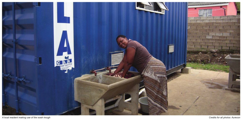
EWS is also acting as an Implementing Agent for the Department of Education (DOE), providing water and sanitation facilities to schools in the Umlazi and Pinetown District areas including capital and maintenance projects. As at October 2010, this project addressed the needs of 35 schools, with further schools to be addressed as budget is provided by the DOE.
Continued on Panel 2.
ETHEKWINI MUNICIPALITY, AURECON AND PROJECT PREPARATION TRUST
eThekwini Municipality: Interim Services Programme (Panel 2)
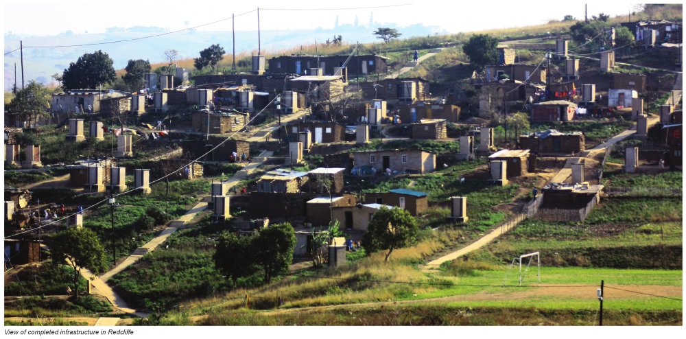
ETHEKWINI MUNICIPALITY: INTERIM SERVICES PROGRAMME
Pilot Projects
Preliminary Precinct-level Master Plans
Preliminary master plans were developed for each of the informal settlement precincts in which the seven targeted pilot projects were located in order to ensure that development occurs in a spatially coherent fashion and that the precincts become integrated with the rest of the City. The plans defined main movement corridors and activity nodes and enabled the prioritisation of those roads most critical from an urban development perspective. They will also inform more effective provision of key social facilities such as fire and police stations, clinics, schools, sportsfields and community halls.
Overview of Roads and Footpaths
An acceptable interim Level of Service in respect of Roads, Footpaths and Storm-water Drainage was established with the various City line departments in order to make effective use of the limited budget currently available. The following factors were taken into consideration in designing the network:
- Where possible, to provide access into the settlements for Emergency Services (e.g. Fire, Ambulance) and Durban Solid Waste for solid waste removal.
- To ensure that the maximum gradient for Fire Fighting trucks was not exceeded.
- Pavement layers consisting of gravel roads, single seal chip and spray or slurry seal were not acceptable as they would lead to short term maintenance being necessary.
- All roads are designed and constructed in line with appropriate engineering codes and practises and in conjunction with their access hierarchy.
- Allowance was to be made for turning heads and passing facilities.
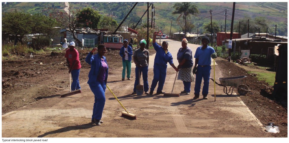
Overview of Electricity Implementation
- Electrical infrastructure is funded/subsidized by the Department of Energy.
- Once roads and footpaths are built, it takes an average of two months for the design and a further two months for installation for a development of 200 sites.
- Aggressive marketing ensures that customers are informed on site about the application process, requirements for electrical connections and the benefits of legal connections as opposed to illegal connections especially with regards to safety and power outages.
Status of Road Implementation
To date, the eThekwini Municipality has authorized the implementation of 3km of roads and 3.5km of footpaths with accompanying storm-water controls in three informal settlements (Kenville, Redcliffe and Greylands) comprising over 3800 households, and has successfully completed two of the projects at the end of August 2011. Labour as well as Community Liaison Officers were sourced from the local communities. The use of local businesses to provide materials and security services was encouraged, stimulating small business development and ensuring that the local economy benefited where possible. A further four informal settlements (Lower Malukazi, Dassenhoek D, Umlazi MX1 and Umlazi Peace Valley) are currently being designed and construction is programmed to commence in 2012.
Sustainable Livelihoods Programme
A Sustainable Livelihoods Programme was incorporated to build stronger community responsibility and ‘self-help’ as well as to facilitate a better relationship between the urban poor and the Municipality. Practical action plans were developed by local residents with the aim of empowering them to play a more effective role in a range of spheres such as special needs (e.g. home based care, crèches and HIV Aids), informal enterprise and food security. This also assisted to identify and define opportunities for community based maintenance and more effective emergency responses (e.g. relating to fire protection).
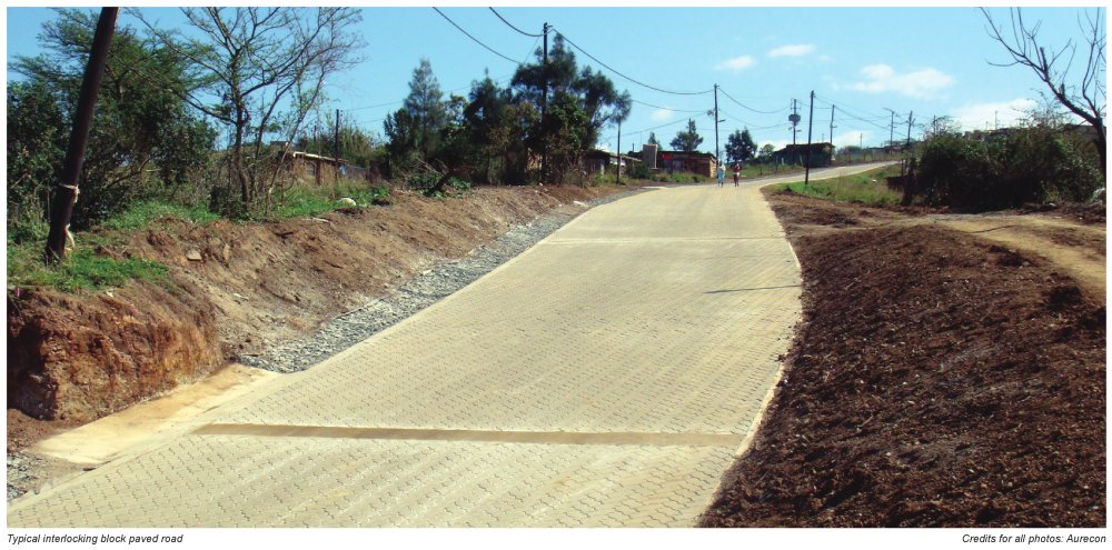
Going Forward
Informal settlements have been grouped together into logical ‘clusters’ or precincts in order to enable more effective and sustainable urban planning. A preliminary precinct-level master plan (as per the pilot projects) will be developed for each of the remaining precincts to ensure that future road networks conform to a logical longterm urban development plan and do not conflict with layout plans for future housing delivery.
Back to Panel 1.
ETHEKWINI MUNICIPALITY, AURECON AND PROJECT PREPARATION TRUST
INNER CITY INFORMALITY
Below is a brief excerpt from each of the projects in this category. Click on the links or image to see the full project panel details and illustrations.
Brook Street Market
Exhibitor: Architects Collaborative cc
The project illustrates the phased development of an urban scale, roofed informal economy trading “mall” that was initiated as a joint venture with the Local Authority, through iTRUMP. The approach was by the Badsha Peer Mazaar Society, who proposed the erection of a permanent roof structure over the portion of Brook Street Central adjacent to their Saint’s Mazaar [shrine] for the dual use of their veneration ceremonies and the daily informal trade already existent in the same space. The initial project has subsequently extended to eight, almost annual, development phases where the roof has been extended to now shelter the entire length of Brook Street Central [approximately 200 m] to which traders’ specific infrastructure has been added. The Project concept has evolved interactively from phase to phase, so is also demonstrative of the attributes of an area based presence in translating daily observation into responsive design and ultimately, infrastructure. The area based presence has also contributed to the maintenance of a strong vision which is necessary to “carry” phased development.
Ekhaya Neighbourhood Project & Upgrades of Existing Buildings
Exhibitor: Savage + Dodd Architects
In 2002, Savage+Dodd Architects undertook a first upgrade of a so-called 'bad building' in Hillbrow for the Johannesburg Housing Company (JHC). Our involvement architecturally was quite limited. Bad buildings are those which have become degraded through lack of maintenance and service provision over years, most have absentee landlords and have been hijacked or been invaded by illegal tenants. Since then we have undertaken many projects of this nature and our involvement has become more intense.
Inner City Movement Framework
Exhibitor: Monica Albonico and Lone Poulsen
The city is an amalgamation of complex layers of people, trade, movement, ever changing requirements and functions, the formal and the informal. All these layers are overlapped and entangled, making them, at times, indistinguishable from one another.
At the core of the city are its networks. These complex connections are played out on the canvas of the modernist city grid, structuring sets of relations, defining the activities and interactions between the formal and informal and shaping the "ordinary", everyday contested spaces.
Jeppe: The Chaos Precinct
Exhibitor: Dr Tanya Zack and Robyn Arnot
Urbanisls who have encountered the area of the city centre roughly bounded by Van Weilligh, Pritchard, Troye and Bree Streets have coined various names for it: The Ethiopian Quarter, Little Ethiopia and Little Addis references 'otherness' and emphasises the association of the area with an 'away' place - an exolicising of our city. Bul no formal planning framework addresses this area's land use as distinctive in the central business district. In fact municipal officials speak informally of the area as the CHAOS PRECINCT.
Recycle Change
Exhibitor: Tanya Zack/ Sarah Charlton/ Bronwyn Kotzen
Nobody wonders where each day they carry their load of refuse, outside the city surely: but each year the city expands...The bulk of the outflow increases and the piles rise higher, become stratified, extend over a wider perimeter.
The label 'homeless' is often applied in a largely undifferentiated manner 10 a wide spectrum of living circumstances. These conditions are often assumed to result from particular personal and most often, economic circumstances. The limitations of this conflation of living conditions with personal circumstances are shown in the lives of informal recyclers in Johannesburg.
Warwick Bridge
Exhibitor: designworkshop : sa
By 1996, when the project was commissioned, the main Railway Station had long been moved from the center of the City to the Warwick Triangle area at it’s western edge. Black commuters were the primary commuter rail users and, under apartheid, the motivation was to remove them from the city.
The consequence was that the area around the station rapidly became a hub of commercial activity, primarily
trading from the city sidewalks, public open spaces, and any other viable location where there was opportunity to do so. Trading was unstructured and unregulated and rapid growth put infrastructural services under pressure for which they were not designed.
Brook Street Market, Durban
BROOK STREET MARKET, DURBAN
Area based contribution towards managing the informal economy for iTRUMP (inner Thekwini Regeneration and Urban Management Programme), eThekwini Municipality Durban 2001-2010
Project Architects: Architects Collaborative cc
Narrative: Richard Dobson, Asiye eTafuleni
BACKGROUND The project illustrates the phased development of an urban scale, roofed informal economy trading “mall” that was initiated as a joint venture with the Local Authority, through iTRUMP. The approach was by the Badsha Peer Mazaar Society, who proposed the erection of a permanent roof structure over the portion of Brook Street Central adjacent to their Saint’s Mazaar [shrine] for the dual use of their veneration ceremonies and the daily informal trade already existent in the same space. The initial project has subsequently extended to eight, almost annual, development phases where the roof has been extended to now shelter the entire length of Brook Street Central [approximately 200 m] to which traders’ specific infrastructure has been added. The Project concept has evolved interactively from phase to phase, so is also demonstrative of the attributes of an area based presence in translating daily observation into responsive design and ultimately, infrastructure. The area based presence has also contributed to the maintenance of a strong vision which is necessary to “carry” phased development.
LOCATION The Project is located in Brook Street Central, directly between the West Street Cemetery and the eastern edge of the Berea Station. The area is a melting pot of cultural history: The cemetery is the oldest in Durban [opened in 1850] and contains Christian, Muslim and Jewish graves. The Muslim section is currently the most actively used. The Berea Station was relocated in the apartheid era and was conceived as a segregated facility ie. with racially exclusive platforms and dedicated circulation routes. The construction of the new Station deliberately managed the access of Black people into the inner city, as it was the only elevated crossing over the rail corridor connecting the inner city with metro wide public transport routes. This reinforced the circulatory significance of Brook Street as the pedestrian distribution point into the inner city districts. The presence of informal traders was a consequence of this heavy pedestrian traffic. Periodically, Muslim funeral processions pass through the area en route from the Grey Street Mosque to the cemetery.
INTERVENTION In its infancy the Project represented a unique joint venture between the Local Authority [iTRUMP] and the Badsha Peeer Mazaar Society, supporting a long standing cultural and religious practice. The Mazaar Society’s approach to iTRUMP gave credence to the possibility of extending the roof along the full extent of Brook Street Central. Although there was no initial financial commitment from either party to fund any subsequent phases [beyond the Society’s first phase] the architectural concept and urban scale anticipated this possibility, hence the now appropriate architectural expression and the functioning of the space as an informal economy trading “mall”. Equally, the urban space and roof has facilitated the unconstrained expansion of the Badsha Peer veneration and provides responsive accommodation for the celebration’s programme.
PROCESS Until the Society’s formal approach to iTRUMP with the proposal to roof a portion of Brook Street
Central, the interaction between the Society and the informal traders’ street committee was based on customary understandings and public spirited co-operation. As the veneration function expanded, along with the density of trading, this interaction became harder to manage and progressively the ITSBO [Informal trade and Small Business Opportunity] area manager was approached to assist with the Society / trader preparatory arrangements. A form of social, economic and spatial threshold had been reached
Continued on Panel 2
.
ARCHITECTS COLLABORATIVE cc
Brook Street Market, Durban (Panel 2)
BROOK STREET MARKET, DURBAN
Area based contribution towards managing the informal economy for iTRUMP (inner Thekwini Regeneration and Urban Management Programme), eThekwini Municipality Durban 2001-2010
Project Architects: Architects Collaborative cc
Narrative: Richard Dobson, Asiye eTafuleni
LEARNING
Receptivity to Stakeholders’ Ideas. The evolution of the Brook Street Central Market was undoubtly as a result of the approach by the Badsha Peer Mazaar Society to erect a permanent roof adjacent to their Mazaar. The idea was unconventional and the innovation required an acceptable joint venture and the redirection of the design to achieve a more substantial outcome.
Concept Evolution: iTRUMP was able to imagine the potential of the initial approach and insist on the implementation of a first phase that accommodated a range of future opinions. The later provision of infrastructure in support of the immediate informal economy activities was evolutionary and responsive to their observed needs and those of the Local Authority eg. the purpose built storage facilities. Key to this achievement was the early production of a flexible master plan and phased implementation.
Phased Implementation: The adoption of a phased implementation strategy has been a key learning for iTRUMP and their projects developed for the informal economy. A number of practical considerations have supported this approach: It has enabled concept evolution in a sector where prior precedent is not generally available. Over time, it has enabled an aggregated, enhanced budget commitment that has translated into a more substantial and significant intervention. It recognized that many of the informal economy activities are survivalist in nature and are therefore vulnerable to disruption. Ensuring that there is income continuity is an important consideration that can best be achieved by phased implementation. It enhances the attributes of area based management in that funds can be placed to maximumize leverage, but spread more uniformally to enable the creation of a broader platform that has the possibility of intersecting projects with commensurate benefit, rather than sequentially “starting at one end.”
Strong Vision: The Project illustrates the need for strong and clear vision as a key requirement for a phased implementation approach. Area based management is one of the only Local Authority approaches that can sustain and evolve this necessity. Line departments can articulate the vision but sustenance depends on area level inputs eg. stakeholder participation, design evolution, on-going maximization of opportunities and local institutional memory. All the latter are the preserve of an area based management approach. Strong vision is also applicable to “holding the course” where the local presence understands the significance of the Project and can retain its prominence over 6-7 years.
Urban Uniqueness: Generally, only an area based presence would have detected the implicit potential of the Society’s proposal. It is speculated that a routine approach into a Local Authority line department would have either lost or diluted the potential. The KZ-NIA Journal [Issue 3 / 2001. Volume No. 26] refers to the Brook Street Central Market as being “akin to the Galleria in Milan” [Italy]. Unique in form, concept and use. The interactive use of the space must rate as an international distinguished practice and occurrence. This practice has also developed a local idiosyncrasy where the local informal trader permits will have a qualifying condition that acknowledges the Society’s annual use of the space ie. informal trade will be restricted during the veneration ceremony! The urban uniqueness is also an important contributor to the post-apartheid transformation of South Africa’s urban centres. This project site is obviously very significant as the “doorstep” into the previously segregated inner city. Cultural fusion is one means of securing sustainable transformation.
Back to Panel 1.
ARCHITECTS COLLABORATIVE cc
Ekhaya Neighbourhood Project & Upgrades of Existing Buildings
EKHAYA NEIGHBOURHOOD PROJECT + UPGRADES OF EXISTING BUILDINGS
Upgrades of existing building and development of neighbourhood framework, Hillbrow Johannesburg, 2002
Project Architects: Savage + Dodd Architects
Client: Johannesburg Housing Company | eKhaya Neighbourhood
In 2002, Savage+Dodd Architects undertook a first upgrade of a so-called 'bad building' in Hillbrow for the Johannesburg Housing Company (JHC). Our involvement architecturally was quite limited. Bad buildings are those which have become degraded through lack of maintenance and service provision over years, most have absentee landlords and have been hijacked or been invaded by illegal tenants. Since then we have undertaken many projects of this nature and our involvement has become more intense.
Each building that is recycled poses its own challenges. Most buildings were in a severe state of decay. In recycling a building, certain key questions were posed as to whether it was sustainable in its current configuration, how it would contribute to the housing stock of the company and what other functions could feasibly be included to make the project socially sustainable. Within a series of buildings, all located along Pietersen Street, a variety of challenges were addressed, from converting an existing residential hotel into rooms with shared facilities – a sought after typology to rehabilitating an iconic 1950's Modernist building. The key sustainable concepts were recycling and repurposing buildings.
In 2004, having analysed their progress, the client decided that there was now enough critical mass of 'good
buildings' and buildings either owned by themselves or under good management, in a specific area of Hillbrow centred on Pietersen Street, to start thinking strategically in terms of a neighbourhood. This was the realisation of the so called 'ripple pond' theory of development. It therefore focused not on the building but on the context.
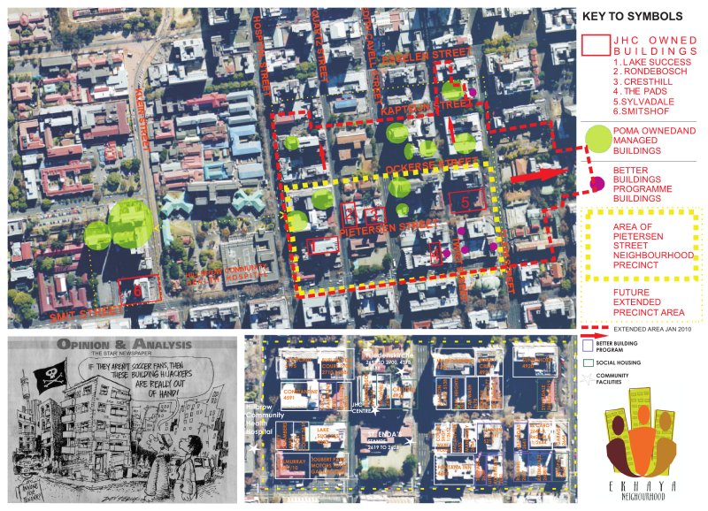
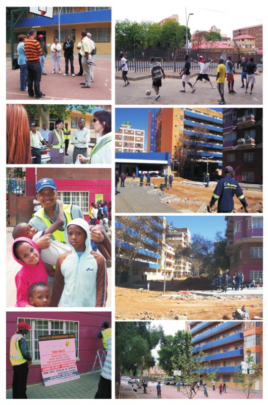
The eKhaya Neighbourhood Improvement Programme (eKhaya) was the first of its kind to envisage forming a residential neighbourhood community in a degenerated low income, high density “no-go” area in the inner city. It was initiated by JHC at a time when they owned three buildings in the neighbourhood, all on Pietersen Street. eKhaya set out to organise property owners, their housing managers and caretakers and residents to co-operate between themselves to create and maintain a safe, clean, healthy and well managed environment, for the benefit of the people who live and/or work in the area, the property owners, and all in the city.
An extensive mapping process was undertaken locating all the buildings – 'good' and 'bad' and public amenities in the vicinity. This formed the basis for discussions concerning common interests with neighbourhood property owners.
One of the first initiatives was to clean up the existing sanitary lanes which were filthy, neglected and dangerous areas where no-one took responsibility for their upkeep. The first manifestations of the eKhaya project were not always focused on the physical environment, but slowly the process of building urban governance, has resulted in people driven changes to the environment, from the carving out of public space and play areas from the streets to the reclamation of urban open space.
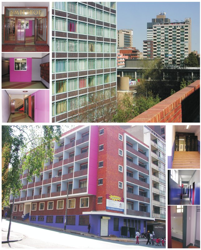
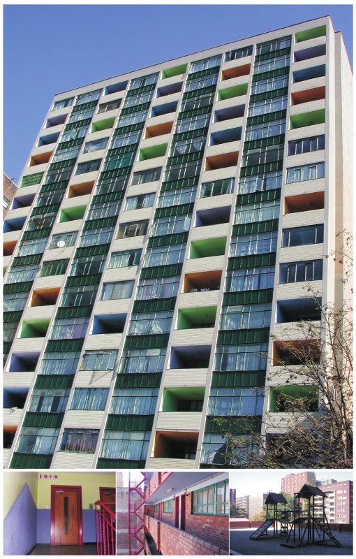
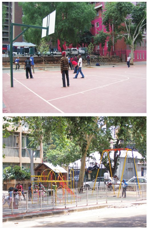
We had seen that previous 'urban design' interventions in the late 80's had actually resulted in very dangerous street areas, especially on Quartz Street. We had also realised that urban space requires urban management, otherwise one makes nice space for drug dealers. Hence, our first urban interventions were not interventions in the physical environment, those interventions had to come out of a people driven process. The first physical interventions were to co-operatively clean and repair the lanes between buildings. This began to establish collaborative relationships between various roleplayers. Out of this, small physical interventions in the street were able to be made. Firstly the area at the eastern end of Pietersen Street was re-structured and repaved to make a playground and ball court area. This has been the site of several very successful community sportsday events organised by eKhaya. This has been the start of physical placemaking. Recently, the eKhaya Park project by Ikemeleng Architects has managed to reclaim an existing neglected and overgrown open space. These interventions are only sustainable within the urban management framework set up by eKhaya. Whilst the physical manifestations of the project were initially upgraded buildings providing a variety of quality accommodation, the most important aspect to this project is that it is a process and not a product. The most important outcomes of the overall project are about building people and building urban citizenship and not about buildings per se.
Continued on Panel 2
.
SAVAGE + DODD ARCHITECTS
Ekhaya Neighbourhood Project (Panel 2)
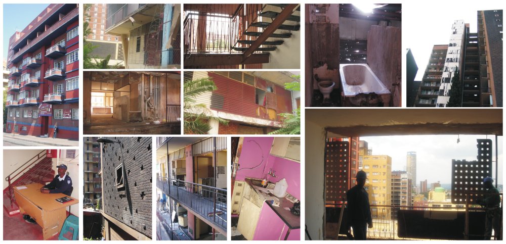
It's about people finding a home in the city, of accepting a place and thereby a reciprocal relationship with their environment for which they start to take responsibility. It is therefore this process which over a period of time starts to impact on the environment.
This is a collaborative project. Through an incremental process of community organising, making contact and
opening channels of communication, eKhaya established a Neighbourhood Association of property owners. This set up a forum for building managers, formed links with other local community organisations and built relationships with city councillors, departments, agencies and law enforcement authorities. It is the proud sense of co-operation, progress and achievement of this community network that drives eKhaya today. The property owners and voluntary involvement of building managers, staff of eKhaya Security & Cleaning Project and residents who give their time and support voluntarily to tackle specific neighbourhood issues. They also organise events that enhance the overall wellbeing of residents and workers that bring the community together.
Over the past four years, as more property owners have joined the eKhaya Neighbourhood Association, the
neighbourhood has been extended and impact of the eKhaya programme have grown. It now covers 16 city blocks, between Smit and Kapteijn Streets, Claim and Klein Streets, and incorporates additional clusters of adjacent residential buildings. By the end of 2008 membership had increased to 17 property owners/agents, with 33 participating buildings. eKhaya directly affects the lives of around 6 000 people living in these buildings, as well as others in the area.
There is increasing awareness by residents in non-member buildings and buildings beyond the neighbourhood of eKhaya Neighbourhood – where people are working 'To make Hillbrow Your Home'.
While it is focused within a defined neighbourhood, eKhaya also addresses the broader concern of sustainable socio-economic regeneration across the inner city. It is founded on the recognition that urban regeneration is not just about upgrading bad buildings and repairing built infrastructure. Nor is it just about good management and ongoing maintenance in buildings and in the public environment. There is growing understanding that genuine development is not an intervention, but a process, in which the positive interests of all involved are met. It is perhaps, most importantly, about building social cohesion and a sense of community, where all stakeholders recognise and assume their responsibilities, accept accountability and develop a shared trust and a shared commitment to their common interests.
One of the first initiatives was to clean up the existing sanitary lanes which were filthy, neglected and dangerous areas where no-one took responsibility for their upkeep. The first manifestations of the eKhaya project were not always focused on the physical environment, but slowly the process of building urban governance, has resulted in people driven changes to the environment, from the carving out of public space and play areas from the streets to the reclamation of urban open space.
Back to Panel 1
.
SAVAGE + DODD ARCHITECTS
Inner City Movement Framework
INNER CITY MOVEMENT FRAMEWORK
Reading and Re-writing, Johannesburg Inner City, 2011
Consultants: Arcus Gibb Engineering, Albonico Sack Metacity (ASM) Architects & Urban Designers with Solam Mkhabela and Marcel Zimmermann.
Funders: The Johannesburg Development Agency (JDA), The Johannesburg Road Agency (JRA) and The City of Johannesburg Department of Transport, Planning & Urban Management
The city is an amalgamation of complex layers of people, trade, movement, ever changing requirements and functions, the formal and the informal. All these layers are overlapped and entangled, making them, at times, indistinguishable from one another.
At the core of the city are its networks. These complex connections are played out on the canvas of the modernist city grid, structuring sets of relations, defining the activities and interactions between the formal and informal and shaping the "ordinary", everyday contested spaces.
The inner city is a place of convergence; where the city finds its voice through the people who engage and dwell in it. It is estimated that 1.5 million people arrive everyday at Park Station and associated taxi facilities, from far away destinations, coming to the area for work, shopping, or leisure. This congested and multi-layered part of the city is also home to about 400.000 residents.
The study conducted as part of the research and analysis phase of the "Johannesburg Inner-city Traffic and Transportation Study", commissioned by the City of Johannesburg, and coordinated by the JDA, engages with the "pulse of the city" at its most revealing point- its heart. It traces the main activities located around transport facilities whilst recording pedestrian movement patterns, places of friction, conflict and coexistence between the formal and the informal. The study looks at the voids- the streets and spaces between buildings which constitute for more than 20% of the urban fabric.
These "shared spaces" are the resource that supports the local trading patterns and allows for a fluid exchange of goods, information, transactions and social interactions, creating multiple opportunities for the new comers and the already entrenched networks.
This study presented the opportunity to observe the city with multiple eyes:
Recording + mapping + counting + tracing + mixing + engaging + enquiring + spontaneous place making + simulating + planning...
By using different techniques assisted by film makers, such as the video recording of critical spaces over 12hr slots, the accurate mapping of movement patterns and spaces of conflict and extensive photographic records of various conditions, unfolded the narrative of the everyday and became readable to the untrained eye of the observer.
The ever evolving purpose and life of a city was one of the key design informants in this research. The development of a framework that is to be successful, must allow for the inevitable interruptions of spaces by its users, and the subsequent growth of the city, whilst still providing a flexible enough base/framework to allow for future requirements.
Continued on Panel 2
.
MONICA ALBONICO AND LONE POULSEN
Inner City Movement Framework (Panel 2)
INNER CITY MOVEMENT FRAMEWORK
Reading and Re-writing, Johannesburg Inner City, 2011
Consultants: Arcus Gibb Engineering, Albonico Sack Metacity (ASM) Architects & Urban Designers with Solam Mkhabela and Marcel Zimmermann.
Funders: The Johannesburg Development Agency (JDA), The Johannesburg Road Agency (JRA) and The City of Johannesburg Department of Transport, Planning & Urban Management
The exhibition explores informality as an interactive process and views projects as generators for new approaches and ways of engaging with it. It is essential to explore and unpack the techniques and methodologies that make urban design a more relevant practice, in order to unleash the potential benefits of urbanity, which are most visible through positive communal meaning and experience in the public environment- public spaces. Urban design processes include understanding context, mapping activities, and participatory engagement, acknowledging constraints, realizing opportunities , exploring alternatives, negotiation and deal making. Urban design as a process becomes a tool for decision-making, mediating between the interests of the individual and the responsibilities of the city.
Urban design translates processes and ideas into spatial interventions that facilitate traditional practices, current livelihoods and future growth. Every city has a unique and personal language of its own, and thus every intervention or design intended for the city, must be unique too.
The frame work presented is based on the principles of building new relationships between the many multi-functional spaces present, bridging the gaps, connecting and providing a sustainable and appropriate base on which the city can grow and improve on. It is supportive of the everyday and the celebratory, but is flexible enough to enable the future. Streets are a critical component of the public space. Their design, conditions and character pray major role in defining the image of the city: affecting its vitality, the health of the inhabitants, quality of life, safety and economic welfare. The access network provides the critical framework for current and future development and growth.
The intention is to " reclaim the street" and put the pedestrian back at the centre, and design and manage the inner-city as a "walkable" and inclusive environment.
Networks and connections are the key interventions. Linking spaces through pedestrian friendly networks, public/communal spaces, public transport facilities and the overall betterment and upgrading of the city environment, gives way for new opportunities for the public.
With minimal interventions, using innovative tactics and strategies, the multi-layered and multi-functional spaces of the city can be explored in ways in which would allow for economic growth and opportunities, functional public interfaces, pedestrian connections and networking.
Back to Panel 1
.
MONICA ALBONICO AND LONE POULSEN
Jeppe: The Chaos Precinct
JEPPE: 'THE CHAOS PRECINCT'
Johannesburg Inner City I 2011
Urbanists who have encountered the area of the city centre roughly bounded by Van Weilligh, Pritchard, Troye and Bree Streets have coined various names for it: The Ethiopian Quarter, Little Ethiopia and Little Addis references 'otherness' and emphasises the association of the area with an 'away' place - an exoticising of our city. But no formal planning framework addresses this area's land use as distinctive in the central business district. In fact municipal officials speak informally of the area as the CHAOS PRECINCT.
The traders in the area call it by the hallmark road - Jeppe. It is significant that a movement route is the selected label for this part of town, for its energy and life force is about converting motorists and pedestrians into shoppers. The 'Jeppe' trading quarter has no fixed boundaries , neither physical nor figurative. It is a place where public and private space is ill defined and the transitions between these are opaque. It is a loud, brash, booming consumer frenzy - an area where the worst of late capitalist, global consumerism combines with the best of migrant entrepreneurial ism. And it operates in ways that defy conventional divisions of formality and informality, of retail and wholesale, of the functions and tasks that support retail hubs, of land use and of the division between public and private space. Each of these elements is blurred in Jeppe. The result is a very distinctive urban form and functionality.
In the early 2000s, the gap for retail in the inner city was captured and in the last 5 years this use has intensified at an extraordinary pace. New shops open daily as retail rapidly appropriates more vertical and street level space. The insatiable consumer hunger of sub-Saharan Africa is now being catered to by hundreds of traders located with enormous precision in the heart of this global transportation hub in Johannesburg's city centre . The area is a shopping receptacle for a great movement of local commuters and cross border shoppers being vomited out and re-ingested into Noord Street taxis and Park Station trains, the Faraday taxi rank and several informal bus and taxi ranks on Jeppe and Delvers Streets. Jeppe captures the footfall of people using taxis and trains from surrounding townships, and from rural South Africa , as well as from Zimbabwe, Zambia, Angola, DRC, Mozambique and beyond.
Not only does Jeppe invite foreign shoppers, but it a hub of almost exclusively Ethiopian traders occupying compact, pocket-sized shops.
It is unsurprising that retail captures the attention of new migrants to Johannesburg. The barriers to entry are low and the prospects seem good. As Solomon, a trader operating from a shop the size of a doorway said,
" In my country, it is hard to sell anything. I have to work very hard to get someone to buy any goods, but in South Africa, if I put a toothbrush on the pavement, someone will buy it. "
Jeppe succeeds in a context where there is an undersupply of retail in Africa. Statistics indicate that the ratio of retail space in Africa is O.01m2 per person, compared with 2.9m2 in the US, O.5m2 in Latin America , 0.4m2 in Europe and O.2m2 in Asia. Added to this is the pent up demand for shopping space in post apartheid Johannesburg, in surrounding townships , in rural areas and in SADC countries (Chung, CJ; Inaba, J; Koolhaas, R; Leong ST, 2001 : 53).
High-rise buildings in Jeppe bear the labels Johannesburg Wholesale 1 and 2, and Majesty, and are interspersed with names like Abyssinia , Joburg Mall, and Nadibas. They sport signage that beckons consumers to enter compact buildings that have "more than 69 shops" to buy, belts , shoes, gold, silver, cosmetics, curtains, clothing.
The retail typology here is neither conventional street level inner city shopping, nor is it shopping mall. Rather it is a hybrid typology that combines the elements of each of these retail types.
Conventional inner city retail trade focuses retail activity on the ground floor, and shops face outwards onto the street. In this typology the upper floors are generally reserved for commercial or residential use; parking occurs in the basements. And road reserves are dedicated to walking: goods are transported by delivery vehicles.
Continued on Panel 2
.
DR TANYA ZACK AND ROBYN ARNOT
Jeppe: The Chaos Precinct (Panel 2)
JEPPE: 'THE CHAOS PRECINCT'
Johannesburg Inner City I 2011
Suburban malls on the other hand host retail activity on multiple levels with shops facing inwards. Parking and loading occur on site in parking lots and delivery zones, and are separated. Shoppers are shielded from all vehicular traffic and the designs aim to achieve 'orderliness, unity and beauty' in a controlled environment.
The characteristics of a typical building in Jeppe combine these elements in a unique way as medical offices have been converted into vertical shopping malls. Here retail and wholesale activity occurs simultaneously on multiple levels and up to six storeys above ground level. Shops face both outwards to the street and inwards onto multiple circulation spaces within the building. For potential traders, the area maximises choice by offering a diverse range of retail spaces.
In the Jeppe hybrid, the land use mix on the upper floors includes retail, commercial and manufacturing, and even churches. Storage occurs on the uppermost levels. Basements might host cars, but also storage facilities and even shops. And intense walking , loading and parking occur in the road reserve, alongside both formal and informal trading.
In an extreme display of agglomeration economics, multiple traders sell similar branded and unbranded goods. It is an unglamorous tapping into the psyche of a nation of spenders, where today's fashion is king.
The similarity of goods repeats in hawker stands that front onto the shops, as each trading space vies for the consumer footfall on the 3m-wide pavement. As a result, the press of pedestrians is then funneled into the 1.5f2m-wide pavement space not occupied by trader stalls and displays. At peak times shoppers, coffee sellers, trolley pushers and pedestrians move in both directions, while also stopping en-route to look or buy. At 3 abreast there are often human traffic jams. And it is not unusual for the negotiations for space to fail utterly for a moment as pedestrian traffic comes to a complete halt.
Nowhere is the sham of the terms 'formal' and 'informal' better demonstrated than in the many layers of legality and illegality, the intricacy of relationships between the traders, the modes of contracting and the allocation and use of space that govern Jeppe.
For neither the formality of a shop nor the supposed informality of a hawker coincides with whether the goods sold are more or less legal , whether taxes are paid , whether invoices are written or whether a relationship exists with the municipality.
This shopping experience is seemingly not 'the mall', except where it is - where street level shops have been converted into miniature malls. Here the usual mall trappings of overhead fluorescent lighting, white floor tiles, uniform shop fittings and the potential to linger, are offered by corridors that have been carved into the building's intestines - shops that are no deeper than the width of a shirt.
As if there can never be enough shops, trading space is subdivided on a weekly basis as one shop evolves into two or more. The frenzy for space has resulted in conversions into split-level shops. Even basement ramps have been transformed into lines of shops.
Respite from the mayhem at street level is found in coffee shops located on several floors. Here groups of mostly Ethiopian men relax, make deals, network, exchange news and arrange savings clubs.
And barbers, internet cafes and CD shops occupy compact spaces that share drywalls with curtaining shops, clothing shops, tailors and with stores selling Ethiopian spices, religious items, ceremonial clothing , and magazines with titles such as ESAU, an acronym for 'Ethiopian-South-African-Unity'.
The activities of trade, delivery, storage and stocktaking happen simultaneously rather than in sequence. Just as trade takes place at all hours so loo delivery is at a constant flow.
Monthly rentals of up 10 R2000 per square metre are being achieved in the most densely shopped parts of Jeppe, in comparison with those of about R140-180/m2 in the body of the inner city, or maximum rentals of R320/m2 in Soweto malls and R800/m2 in Sandton malls. In fact rentals in Jeppe rank amongst the highest retail rentals in the world.
The public environment can be inhospitable. Neither traders nor municipal entities pay much attenlion to pedestrian comfort in what is the most intensely walked area of the inner city.
Building conditions are variable. Robust trading and turnover and high rentals do not translate into investment in buildings. Lifts work intermittently, fire escapes are often blocked up, and there are numerous fire hazards. Despite its material and economic logic, the area is crowded, decaying, congested , and bursting at its seams. But Jeppe is now the throbbing heart of the city.
Back to Panel 1
.
DR TANYA ZACK AND ROBYN ARNOT
Recycle Change
Nobody wonders where each day they carry their load of refuse, outside the city surely: but each year the city expands...The bulk of the outflow increases and the piles rise higher, become stratified, extend over a wider perimeter.
- Italo Calvino, Invisible Cities
RECYCLE CHANGE
Trolley pushers in Johannesburg
Location: Johannesburg
Contributors: Tanya Zack | Sarah Charlton | Bronwyn Kotzen
The label 'homeless' is often applied in a largely undifferentiated manner to a wide spectrum of living circumstances. These conditions are often assumed to result from particular personal and most often, economic circumstances. The limitations of this conflation of living conditions with personal circumstances are shown in the lives of informal recyclers in Johannesburg.
Informal recyclers comb the dustbins and sidewalks of residential and commercial neighbourhoods for selected solid waste items with resale value, which they load onto makeshift trolleys. On foot and with sheer muscle power they pull their loaded carts for many kilometers through the streets to privately owned buy-back centres where the waste material is weighed and sold.
Recyclers operate independently of labour regulations and protection, without employee benefits, using improvised transport, and frequently - inadvertently - contravening by-laws and city rules in their living and working activities. But they are intimately entwined with the formal, recognized systems of urban life: essential suppliers to registered recycling businesses, intense users of city roads, sidewalks and public spaces, specialised reclaimers competing daily with the crude appetite of Pikitup trucks.
The lives of recyclers reflect a wide variety of circumstances. Many are 'sleeping rough' or 'informally' on a regular basis, but are engaged in regular productive work. Informal recyclers in Johannesburg contest conventional notions of homelessness in at least three ways: the diverse reasons for their nightly sleeping arrangements, the range of alternative accommodation they make use of, and in their personal circumstances.
Recyclers choose to spend work nights in Johannesburg to save on transport costs, to be ready to start their outbound journeys to suburbs very early in the mornings. They choose spaces where their accommodation may be cramped but they are able to store their goods. Recycling work involves gathering and then sorting the load prior to having it weighed at the depot. Recyclers need space and time for separating and sorting items. They also need place to stockpile until they have amassed enough of a particular material to make exchange at the depot worthwhile.
ACCOMMODATION TYPOLOGIES
REGULAR STREET SLEEPERS HAVE DIFFERENT MOTIVATIONS AND HOUSING NEEDS FROM THE CITY'S 'DESTITUTE HOMELESS', INDEED SOME ARE PROPERTY OWNERS IN THEIR OWN RIGHT. THE FOLLOWING EXPLAINS ACCOMODATION TYPOLOGIES CATEGORISED AS EITHER 'ROUGH SLEEPING" OR 'NON-FORMAL ACCOMMODATION.
Researched conducted in 2009 by Urban Planning students in the ARPL 3013 course at the University of the Witwatersrand, School of Architecture and Planning. Johannesburg. South Africa
Continued on Panel 2
DR. TANYA ZACK/ SARAH CHARLTON/ BRONWYN KOTZEN
Recycle Change (Panel 2)
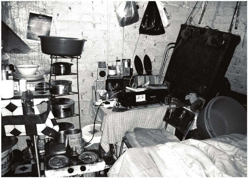
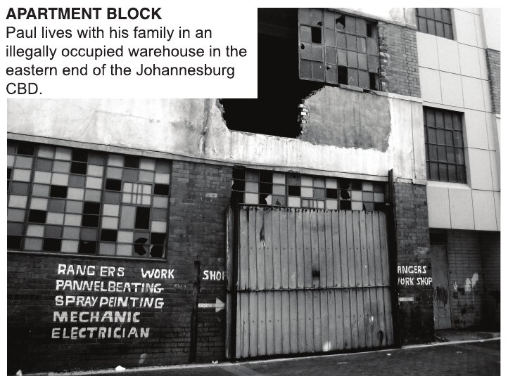
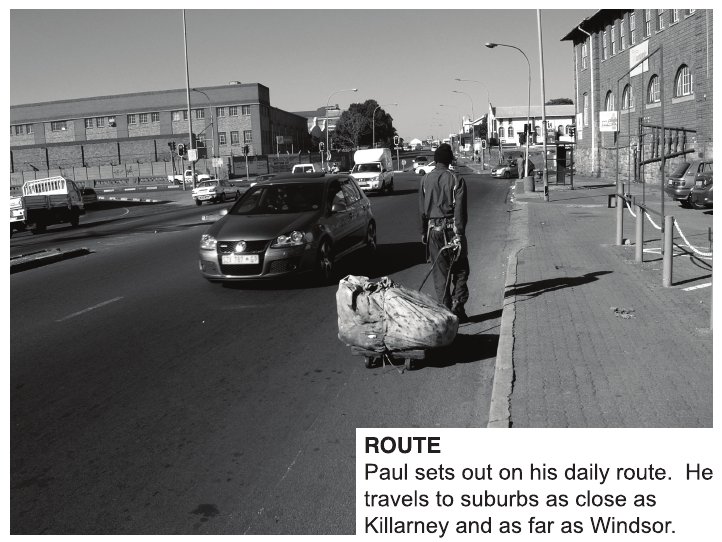
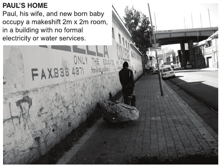

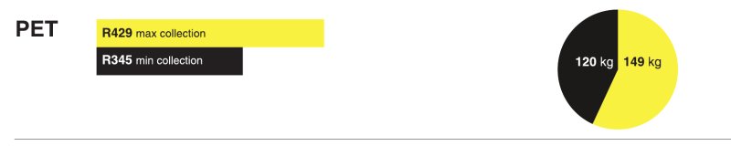
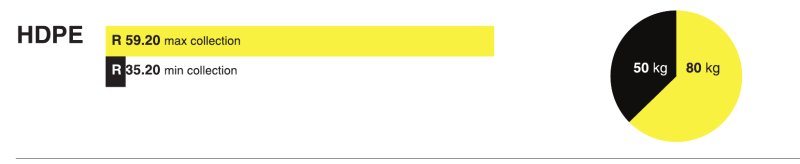
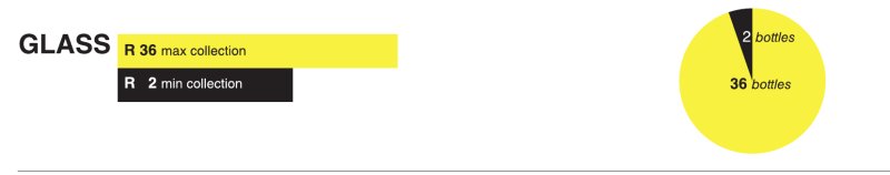
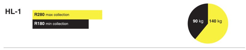
RECYCLE CHANGE
The story of Paul the trolly pusher
Location: Johannesburg
Contributors: Dr Tanya Zack | Sarah Charlton | Bronwyn Kotzen
Paul's story illustrates the tradeoffs recyclers make to optimize their income whilst keeping their living costs to a minimum. He works long hard hours and lives cheaply. In this way he manages both to support his household and extended family, and save for the future.
The business of informal recycling depends on the prices paid by buy-back centres for particular categories of waste. On a good week Paul can earn up to R1 100.Typically he makes R 800-900 per week. To earn R1 100, Paul must pull almost 600 kg over five days. He sells his reclaimed materials every two weeks, when he has accumulated enough quantity of each item to make the transaction worthwhile.
Paul lives with his partner and baby in an illegally occupied warehouse in the eastern end of the Johannesburg CBD. They occupy a makeshift room 2m x 2m, in a building with no formal electricity or water services. Paul pays rent to a building committee who manage security and cleaning for the residents. Living cheaply enables him to support his family in Joburg whilst at the same time sending R 1000 a month to relatives Lesotho, where his home is. He also deposits R 1000 a month into his savings account.
Living centrally means Paul walks far to source material before it is claimed by other recyclers. Closer - in suburbs such as Yeoville and Kensington have too many recyclers already working these areas. Increasing competition requires him to set off earlier and earlier in the morning to get ahead. But he lives conveniently close to the three recycling centres he sells his stock to.
Before taking the materials to be weighed at the recycling stations, Paul separates items according to category. Being able to accumulate, store and sort material near to the buy-back centres is a key part of his business. It is important to note that while Paul is an example of a success story of the informal recycling industry, many recyclers in Johannesburg are not in the same position. For many it is simply a means “just to make enough money to eat" as twenty year old Njabulo who lives under the M1 highway bridge explains. Nevertheless, recycling remains a viable and accessible industry in Johannesburg.
Paul the Trolley Pusher
RECYCLABLES
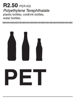
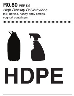
WORK WEEK
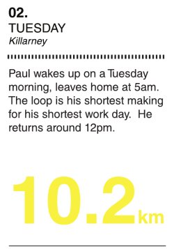
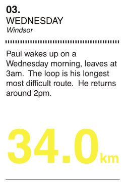
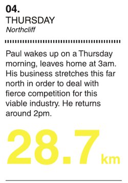
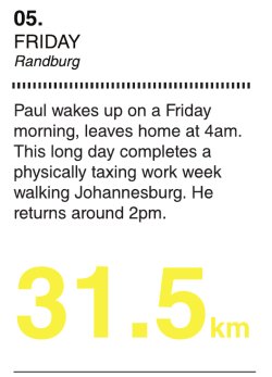
WINDSOR ROUTE
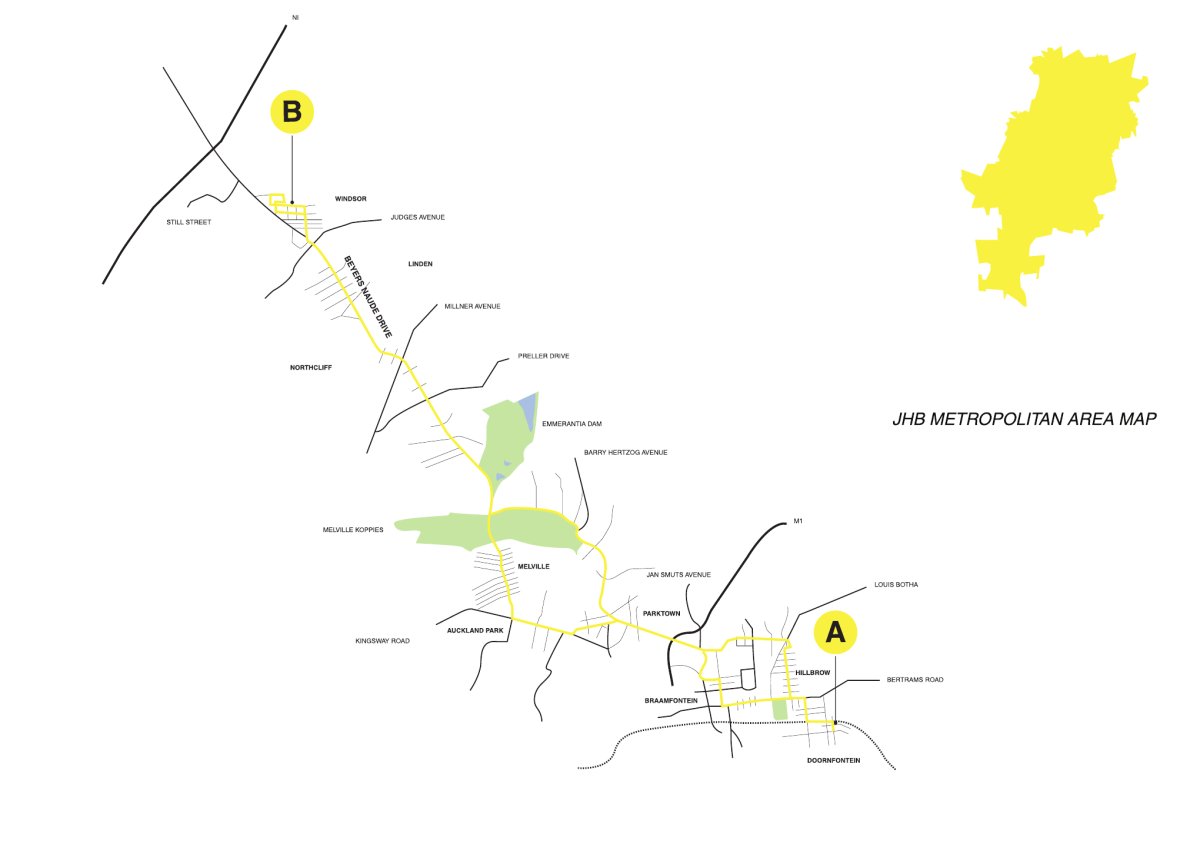
Back to Panel 1
DR. TANYA ZACK/ SARAH CHARLTON/ BRONWYN KOTZEN
Warwick Bridge
WARWICK BRIDGE
Warwick Triangle, Durban 1996
designworkshop : sa
Ethekwini Muncipality
context, objective and brief
By 1996, when the project was commissioned, the main Railway Station had long been moved from the center of the City to the Warwick Triangle area at it’s western edge. Black commuters were the primary commuter rail users and, under apartheid, the motivation was to remove them from the city.
The consequence was that the area around the station rapidly became a hub of commercial activity, primarily trading from the city sidewalks, public open spaces, and any other viable location where there was opportunity to do so. Trading was unstructured and unregulated and rapid growth put infrastructural services under pressure for which they were not designed.
Sidewalks were unwalkable, refuse was generated quicker than it could be collected, drains continuously blocked, and pedestrians were knocked down as they tried to cross increasingly busy streets. Much of this was happening in the area of and between the new Berea Station, the Early Morning and Fresh Produce City Markets, the emerging 16-seater mini-taxi ranks, and adjacent bus terminuses.
At the same time, influx of people from rural areas was increasing rapidly. The city was being evacuated by its previous predominantly white business and residential population and the void was being filled by the newly urbanising. The urban economy, society and culture was transforming.
On the one hand there was a vacuum. On the other, pressure. This is a condition of great opportunity.
One of many examples of the newly legitimised urban economy, culture and society was the prescription and trading of traditional medicines; traditional equivalents of doctors and pharmacists. Without a defined location, this growing specialist industry was rapidly occupying sidewalks in the area and, because of market demand, blocking pedestrian through-movement and contributing to the clogging of the pedestrian environment.
Stretching up from the city side, in the location of the Victoria Street Market, were two incomplete and abandoned freeway splines; their radii apparently too tight for their purpose which was to reduce in and out bound traffic from the Warwick area by bridging over it.
iTrump [Inner City eThekwini Regeneration and Urban Management Programme], an entity of the eThekwini Municipality, saw the opportunity of extending an existing piece of abandoned infrastructure to create an above-ground pedestrian linkage from the Berea Station, across Market Road and drop it down at the busy on-grade pedestrian intersection at the entrance to the Early Morning Market.
In this single move, unviable, unsafe and unsustainable volumes of pedestrian movement at ground level would be relieved; the specialist prescription and trading of traditional medicine would be consolidated, from which would emerge a location and product based identity for the sector; a cultural practice would be assertively validated; and another piece of a unique emerging urban society would be added.
Bottom up management structures were put in place so that this community was organised, could formally relate to and engage with the city authorities, supportive infrastructural services provided, and self-organised safety and security could be achieved.
‘Ecology’ means the mutually beneficial relationship between different organisms and their environment. With minimal intervention, intimate integration of and between all stakeholders, and an inherent respect for the validity of traditional cultural practice, the conditions for a sustainable urban ecology were to be provided. With very little resource, city government was catalysing a powerful urban evolution.
The brief to designworkshop : sa was to design consulting rooms for the Izinyanga [traditional doctors], trading spaces for the Izangoma [traditional healers and traders], and the bridge and stair connection from the end of the abandoned freeway to the ground at the entrance to the Early Morning Market.
The process required a degree of understanding of, and feel for, the traditional medicine ‘industry’, its heritage and cultural context; the relationship between the Izinyanga and Izangoma and their customers; and the physical environment that would enable these relationships.
There was also an up-front understanding that, if they are not going to end up as extended corporate shopping malls that serve only to further concentrate wealth in the hands of a few, the inherent attribute of ‘city as an accessible market’ was going to be a fundamental driver for the project.
Continued on Panel 2
.
designworkshop: sa
Warwick Bridge (Panel 2)
WARWICK BRIDGE
Warwick Triangle, Durban 1996
designworkshop : sa
Ethekwini Muncipality
response, delivery and outcome
As a major intermodal transport interchange, Warwick is an entrance and exit portal to the city. Not only for people coming and going from suburbs of all kinds on the perimeter of the city, but also for people continuously coming and going between the city and rural areas far beyond it.
This unique phenomenon of people living equally in two very different places – the post industrial city and the traditional rural hinterland -, separated only by time, presents a very interesting opportunity in the design of the threshold where these two worlds meet within the individual human experience. Warwick is this threshold.
In addition to its functional purpose, the freeway splines and the bridge were also opportunities for representation of the transformation of the economy, cultures and society of the city, and it’s transforming relationship with its hinterland.
The objective of the design was to use as few resources as possible to provide an enabling environment for the Izinyanga and Izangoma on the abandoned freeway splines so as to maximize their trading opportunity and therefore economic performance; seamlessly bridge from this trading environment over Market Road and down to ground at the entrance to the Early Morning Market; and use this bridge as a symbol of the overlap between the urban and rural realities of many South Africans.
Symbols are the essentialising of complexity.
Both the trading structures on the freeway splines and the bridge structure are assemblies of separate dry elements; there is little to no wetworks. They are mostly either parts of trees [timber poles] or their form makes reference to trees. The tree is the ultimate symbol of shelter and protection, and of gathering. It is also a symbol of fertility, resource and growth. And it is an icon whose relevance is retained as it is transported across the seam that both joins and separates urban and rural.
Durban is a port city. Without the port, the metropolitan economy as we know it would not exist. Like the ocean, this is internalised within all of us that live here, both as imagery and as an understanding of what that imagery implies and means. The underslung trussed structure that supports the pedestrian bridge remembers the fabricated engineered assembly methodology of this industry. It is lean, a ribcage.
One end of the truss is supported on the sheer concrete wall that ends the freeway splines, and upon a huge painted image of Mama Afrika. The other end is supported on a series of bifurcated sinuous steel columns as trunks that transform into bows that support the shading isingtingu [saplings] parasol.
Geometries were decided through the process of making a soldered wire model, photocopying it, scanning the photocopy and tracing its shapes.
Fabricated in a simple open-sided shed outside of the city, the structure was erected and assembled over a weekend. Secondary activities were completed and within a short period of time, a blocked artery between two severed parts of the city was opened. Connectivity. Urban surgery. Healing. New growth. Ecology.
When the central city Railway Station was relocated to Warwick, it unknowingly catalysed an opportunity for intense economic, social and cultural urban transformation. A web or matrix of free-flowing and integrated movement routes that link essential destinations are key to economic opportunity. The free expression of cultural practice is essential to diversity that is a key element of a sustainable integrated urban and rural ecology. The freedom for people to autonomously determine their own destinies within a structured and integrated matrix of opportunity is essential to the cohesion, evolution and stability of a transforming society.
Symbols that essentialise this vibrant, energised and dynamic complexity legitimise and encourage its growth and consequential indices of a healthy society: reduction in poverty, increase in sustainable economic activity, and an efficient relationship between production and consumption.
This is a sustainable ecology, the mutually beneficial relationship between organisms and their environment. Alongside all others, humans are an organism. The city is now our primary habitat. This project is a small catalytic example of making it. It is testimony to the vision and foresight of the entities of the eThekwini municipality that enabled it.
Back to Panel 1
.
designworkshop: sa
UN-BUILT PROJECTS
Below is a brief excerpt from each of the projects in this category. Click on the links or image to see the full project panel details and illustrations.
Diepsloot – Housing & The Informal City
Exhibitor: 26’10 South Architects and Lone Poulsen
In this research inquiry, Diepsloot’s Reception Area has been used as a basis against which to ‘test’ existing formal housing typologies and to develop alternative strategies which respond to and learn from the dynamics of the Informal City. Diepsloot is a predominantly informal settlement located 40km north of Johannesburg’s city centre. As a post-apartheid township it acutely represents the challenges facing the South African state on matters of housing, service delivery and effective local governance. Based on detailed mappings of Reception Area produced by 26’10 south Architects, a master class involving various architects and housing specialists was held exploring the complex relationship between housing density, occupation density, built form and customisations such as rental rooms, small businesses and the delineation of communal and public spaces.
Diepsloot - Diep Soak & Curl
Exhibitor: 26’10 South Architects
This competition entry suggests an alternative approach to the provision of services in the upgrading of informal settlements. Whilst formal upgrading approaches concerned with defining ownership, security of tenure and eventually housing delivery are long and arduous processes, something can be done in the interim to improve inhabitants’ quality of life as well as stimulate the local economy through the provision of basic services. In fact, the failure of services that plagues informal settlements presents obvious opportunities for employment and development. Phase 2 of the Expanded Public Works Community Programme even makes provision for this.
Informal Studio - Ruimsig
Exhibitor: 26’10 South Architects in partnership with the Goethe-Institut SA, the University of Johannesburg and Prof. Lone Poulsen
The INFORMAL STUDIO: R U I M S I G has been carried out in partnership with the Goethe-Institut and the University of Johannesburg as an in-situ course on informal settlement upgrading. Sixteen masters students, together with residents of Ruimsig (an informal settlement on the western periphery of Johannesburg), have produced a detailed mapping and re-blocking study. The course was run partially from a studio within the settlement were students and teachers worked with local community architects in a process guided by NGOs and grass-roots organisations. This in-situ interaction formed a vital component linking theory and practice, ‘clients’ (residents), and service providers (students and teachers).
Sans Souci Cinema
Exhibitor: 26’10 South Architects, Lindsay Bremner
In the absence of a budget and local capacity to re-build the famous Sans Souci Cinema in Soweto, Johannesburg, the content rather than the container was realised. Through harnessing informal networks and local talent, the dramatic ruin of an old cinema formed the armature for a series of cultural events in one of Johannesburg’s poorest communities. The project set out to demonstrate that cultural production need not be limited to formal institutions and that relevant, rich and hybrid cultural identities and practices emerge from the perceived margins and interstices of the city.
Subsidised Housing Assets
Exhibitor: Finmark Trust
South Africa’s national housing subsidy programme, which was introduced with the advent of the first democratically elected government in 1994, has been lauded internationally as a highly significant and ultimately successful housing intervention. The programme provides qualifying beneficiaries (households who earn a monthly income of less than R3500 per month and satisfy other criteria) with freehold tenure over a 40m2 house on a 250m2 plot of serviced land. It is highly likely that the significant increase in the number of South African households living in formal dwellings between 1996 and 2007 – from 64.4% to over 70% - is primarily as a result of this national subsidy programme. The National Department of Human Settlements reports that between 1994 and 2009, a total of 2.94 million subsidy houses were either delivered or still under construction. Of these, 1.44 million (51%) have been formally registered in the Deeds Registry. These registered subsidy houses comprise just under one quarter (24%) of all registered residential properties in South Africa – clearly a significant proportion of South Africa’s property market.
Diepsloot - Diep Soak & Curl
INFORMAL CITY: DIEPSLOOT
Diepsloot Reception Area, Johannesburg, 2009
First Fix - Autodesk Open Think Box Competition 2009 - Winner of Professional Category
26’10 Team: Thorsten Deckler & Anne Graupner (principals), Tahira Toffah, Guy Trangoš, Shameemah Davids
This competition entry suggests an alternative approach to the provision of services in the upgrading of informal settlements. Whilst formal upgrading approaches concerned with defining ownership, security of tenure and eventually housing delivery are long and arduous processes, something can be done in the interim to improve inhabitants’ quality of life as well as stimulate the local economy through the provision of basic services. In fact, the failure of services that plagues informal settlements presents obvious opportunities for employment and development. Phase 2 of the Expanded Public Works Community Programme even makes provision for this.
In Diepsloot’s Reception Area, the failing sanitation system comprising communal toilets and water points results in 7.2 km of daylight sewage affecting the health of its approximate 25 000 inhabitants. The state is in the process of upgrading (reinstating) this failing system without addressing any of the factors which have contributed to its failure in the first place. This scenario forms the basis for a ‘First Fix’ strategy developed for the competition.
When considering growth over time (in the form of self-constructed rental rooms or backyard shacks), the RDP type in fact performs as well as the much touted row-house and delivers densities approximating those of Reception Area. However, the siting of the RDP house in the middle of its plot results in poor in-between spaces when rental rooms are added over time.
Simultaneously, the existing settlement infrastructure and social amenities are often overburdened by the increased occupation. Interestingly, Chitungwiza on the outskirts of Harare, Zimbabwe presents an effective alternative in which two freestanding houses are joined along a shared boundary leaving enough space for rental rooms to define a quality semi-private communal space. The row-house type, promoted as the alternative to the free-standing RDP, starts out with higher initial densities, but has limited growth potential over time due to the inconvenience of tenants passing through the main house to access their accommodation. Units with passages on one side or access lanes at the back of stands may alleviate this to a degree. Whilst BNG (‘Breaking New Ground’) principles have been developed to render houses ‘safe’ as collateral for bank loans, current densities are not particularly efficient in the use of land and infrastructure. The banks furthermore frown upon self-constructed additions.
Due to Reception Area’s complex and dense urban fabric, the strategy is realized in three scales: an existing toilet upgrade, a medium-sized toilet and shower facility, and a large service centre with toilets, comfortable bathrooms, laundry and community services.
The large units are arranged around semi-private courtyards. Besides regular bathrooms, they contain retail spaces which could be used by a hairdresser, internet cafe, laundry, tuck-shop, crèche, gym, etc. The two roof terraces can be used for drying clothes and by the gym as outdoor exercising spaces respectively.
Through incorporating lessons learnt from the dynamic urban and architectural character of the Reception Area, the facilities are cross-programmed to offer multiple services and income streams. All typologies would provide business opportunities for local caretakers and operators.
An environmentally sustainable approach is advocated in that the medium and large units employ a biogas digester, which will assist with the revival of river ecologies and improvement of water quality. Most large units are thus located near the river edge and can promote the revitalizing of this space as natural amenity. Methane, another by-product, can be used as fuel for public lighting and heating. Hot water can be sold for nominally less than what it costs to heat it with traditional fuels.
This proposal posits the notion that just as a multitude of services are offered in the informal city, so public infrastructure can become a service offered to residents. This requires a lateral shift in thinking beyond the confines of specialised civil engineering and back into time, when the early industrialising cities’ bathhouses and serviced rooms in boarding houses catered to the needs of its migrant and temporary workforces attracted to jobs and opportunities. Providing dignified amenities in informal settlements hitherto suspended in an illegal, temporary limbo may be the first step in the slow process of formalising the many informal cities as legitimate parts of the city. As such, this project conceptually outlines an unexplored role for professionals of the built environment to work more creatively in multidisciplinary developmental teams considering some of the more pressing needs of a rapidly urbanizing society through embracing, rather than eschewing complexity.
26’10 SOUTH ARCHITECTS
Diepsloot - Housing & the Informal City
HOUSING & THE INFORMAL CITY RESEARCH PROJECT
Diepsloot Reception Area Johannesburg, 2008
Project partner: Goethe-Institut, Johannesburg
Collaborator: Prof. Lone Poulsen
26’10 Team: Thorsten Deckler & Anne Graupner (principals), Tahira Toffah, Guy Trangoš, Shameemah Davids, Claire Lubelll
In this research inquiry, Diepsloot’s Reception Area has been used as a basis against which to ‘test’ existing formal housing typologies and to develop alternative strategies which respond to and learn from the dynamics of the Informal City. Diepsloot is a predominantly informal settlement located 40km north of Johannesburg’s city centre. As a post-apartheid township it acutely represents the challenges facing the South African state on matters of housing, service delivery and effective local governance. Based on detailed mappings of Reception Area produced by 26’10 south Architects, a master class involving various architects and housing specialists was held exploring the complex relationship between housing density, occupation density, built form and customisations such as rental rooms, small businesses and the delineation of communal and public spaces.
In South Africa, density is generally accepted to be low at less than 40 units/ha, medium at between 40 and 100 units/ha and high at more than 100 units/ha. Reception Area’s existing density at 300 units/ha (predominantly one storey), its quality of spaces and diversity of functions point to the potential for low rise, high-density solutions which may be freehold and offer opportunities for sub-letting and small scale enterprise. A one hectare piece of land situated along a busy street of Reception Area was used to compare different formal housing approaches measured in terms of the displacement or additional accommodation each settlement type achieves.
When considering growth over time (in the form of self-constructed rental rooms or backyard shacks), the RDP type in fact performs as well as the much touted row-house and delivers densities approximating those of Reception Area. However, the siting of the RDP house in the middle of its plot results in poor in-between spaces when rental rooms are added over time.
Simultaneously, the existing settlement infrastructure and social amenities are often overburdened by the increased occupation. Interestingly, Chitungwiza on the outskirts of Harare, Zimbabwe presents an effective alternative in which two freestanding houses are joined along a shared boundary leaving enough space for rental rooms to define a quality semi-private communal space. The row-house type, promoted as the alternative to the free-standing RDP, starts out with higher initial densities, but has limited growth potential over time due to the inconvenience of tenants passing through the main house to access their accommodation. Units with passages on one side or access lanes at the back of stands may alleviate this to a degree. Whilst BNG (‘Breaking New Ground’) principles have been developed to render houses ‘safe’ as collateral for bank loans, current densities are not particularly efficient in the use of land and infrastructure. The banks furthermore frown upon self-constructed additions.
The housing types proposed during the master class for the Diepsloot context attempt to achieve a much higher stand and occupational density from the outset in order to achieve the minimum displacement of existing residents. In addition, the housing types enable eligible beneficiaries to become small scale landlords who rent habitable rooms to non-eligible residents. The flexible design of the proposed housing types therefore incorporates future growth for income generation through accommodating rental rooms, retail and small business enterprise. The unit types are located close to the street boundary to create a sense of urbanity, natural surveillance, ease of trading and to limit the amount of unusable space between units. Micro-loans, in addition to a basic starter unit (funded by means of the subsidy), can assist owners to construct quality rental rooms as per various pre-defined options. Part of the resultant rental income would go towards repaying the loan. Both the Vertical Yard type and the 14x7m Row House type offer two approaches to achieving high density and growth over time.
Both unit types move away from the ‘shrunken mansion’ syndrome satisfying a perceived aspiration towards a dynamic flexibility which can deliver subsidised housing in which the unit becomes an asset for income generation. Whilst the proposed starter types are bigger than the standard RDP type, they can, through savings made (due to higher density), on land cost, infrastructure and service provision, be imminently achievable. In addition, the availability of micro loans should offer even further choice to beneficiaries to customise their dwellings to suit their specific needs. The increased densities also achieve the necessary thresholds for the efficient provision of public transport and economic opportunities.
WEBSITE: http://www.housinginformalcity.co.za
26’10 SOUTH ARCHITECTS IN PARTNERSHIP WITH THE GOETHE-INSTITUT SA AND PROF. LONE POULSEN
Informal Studio: Ruimsig

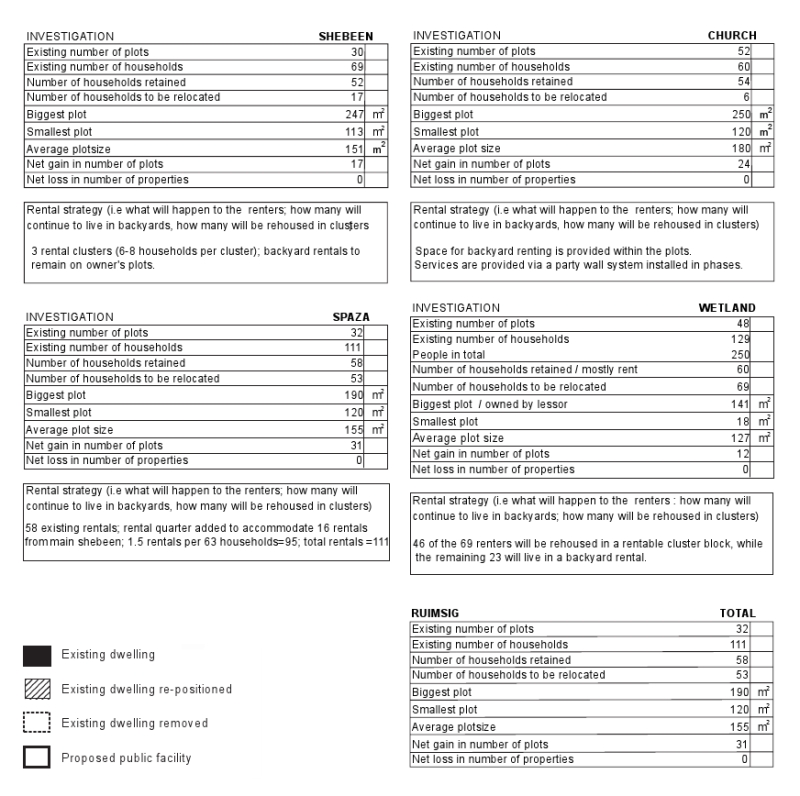
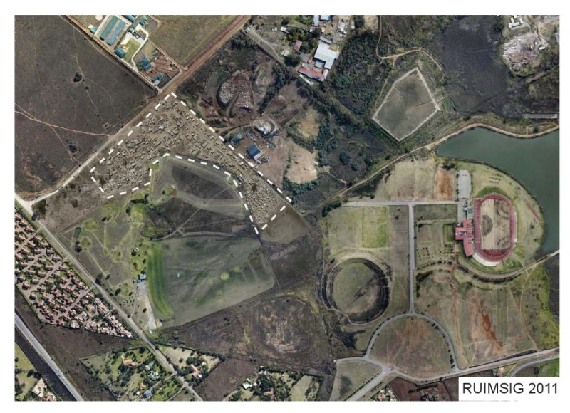
- click images to see larger version -
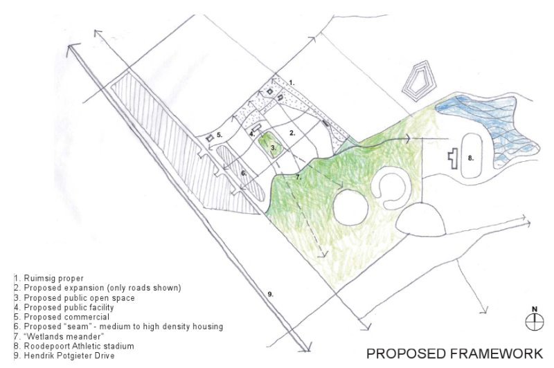
INFORMAL STUDIO: RUIMSIG
Ruimsig Johanneburg, 2011
Project Partners: 26’10 South Architects, Goethe-Institut Johannesburg and the University of Johannesburg
Lecturers: Thorsten Deckler, Prof. Lone Poulsen, Alexander Opper (UJ), Melinda Silverman (UJ)
The INFORMAL STUDIO: R U I M S I G has been carried out in partnership with the Goethe-Institut and the University of Johannesburg as an in-situ course on informal settlement upgrading. Sixteen masters students, together with residents of Ruimsig (an informal settlement on the western periphery of Johannesburg), have produced a detailed mapping and re-blocking study. The course was run partially from a studio within the settlement were students and teachers worked with local community architects in a process guided by NGOs and grass-roots organisations. This in-situ interaction formed a vital component linking theory and practice, ‘clients’ (residents), and service providers (students and teachers). The collaborative output of the studio is the first version of a reblocking map showing how minimal shifts and adjustments in what is ostensibly a ‘temporary’ urban condition and fabric can lead to a more equitable distribution of space, the undoing of exploitative rental conditions, the creation of legal road reserve widths (for more effective circulation including emergency services) and future provision of sanitation, water and electricity supply. In addition, the re-blocking facilitates the process of awarding tenure and can ‘bracket’ space for future social amenities. Working with the ISN (Informal Settlement Network) has made possible a meaningful engagement in a people’s process for change and points to new ways of practice for architects and more fundamentally a shift away from the obsession with the single formal house constructed (at great expense) for and not by people.

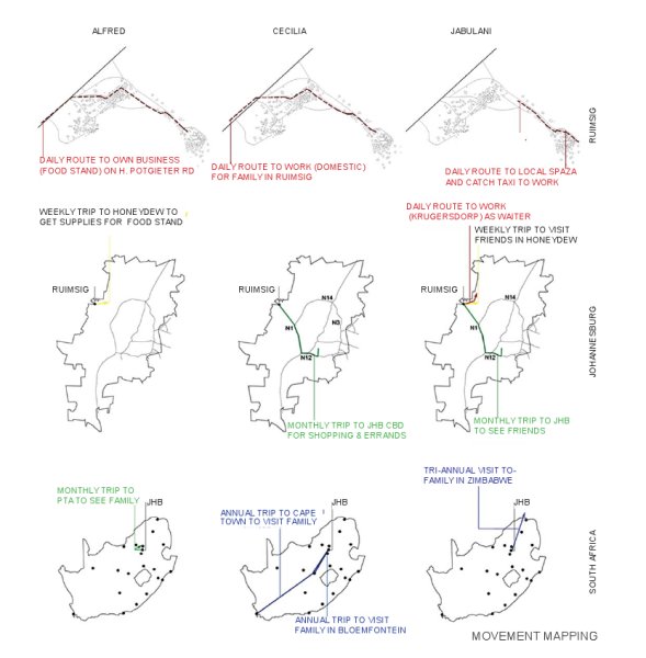
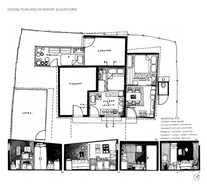
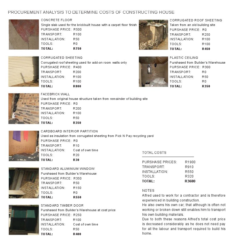
- click images to see larger version -
Questions the studio raised revolved around the ‘perceived’ backlog of 2.5 million formal houses. To students it became clear that the informal city in this case does what the formal system cannot: it provides affordable shelter and a foothold closer to opportunities of employment and advancement. The informal city, constructed by inhabitants themselves with little input from the state or professionals, offers flexible and affordable access to shelter.
In some instances, it displays spatial and programmatic richness sorely lacking from the housing landscapes constructed by teams of professionals. Yet the lack of services, security of tenure, repeated threats of ‘eradication’ and the promise of eventual housing delivery have locked the informal city into an illegal limbo in which mounting tension and frustration are becoming increasingly evident.
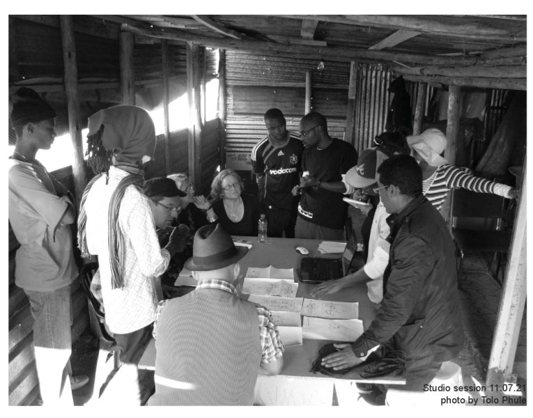
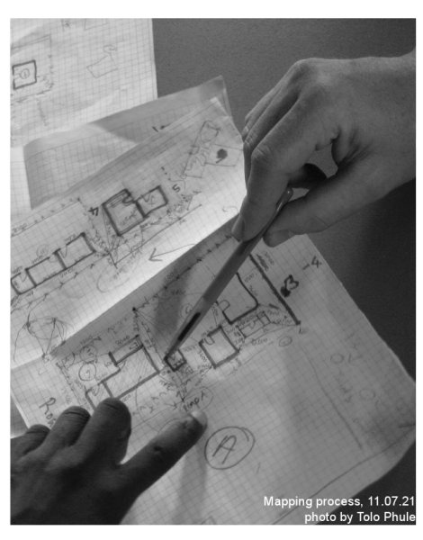
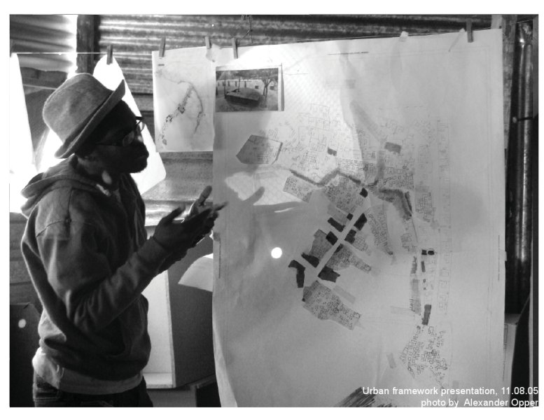
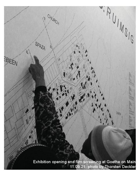
- click images to see larger version -
Encouragingly, but not surprising, the state’s previous ambition to eradicate informal settlements by 2014 has been redefi ned and refocused (courtesy of the National Delivery Agreement targets) to the upgrading of 400 000 units in well-located informal settlements by 2014. To this effect the National Upgrade Support Programme (NUSP) has been established to assist the state and communities in realising this target. For South Africa this demands a major shift in thinking about housing and how it has been delivered in the past. It acknowledges the efforts people have made in building their own homes and communities. No matter how defi cient, tenuous or exploitative the informal city may be – it directly mirrors the ever increasing backlog in formal housing. Considering that just about 60% of all urban inhabitants in Africa live in informal conditions, it is time for a mode of professional practice which embraces housing as a process rather than a product. The INFORMAL STUDIO: R U I M S I G thus positions itself to educate professionals in becoming skilled in engaging with a process of housing that is not about houses as finished, professionally executed products but about a people-driven process towards improved living environments.
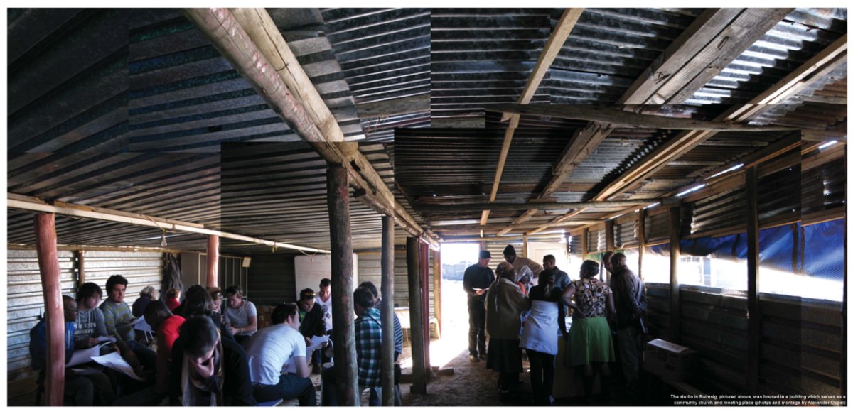
26’10 SOUTH ARCHITECTS IN PARTNERSHIP WITH THE GOETHE-INSTITUT SA,
THE UNIVERSITY OF JOHANNESBURG AND PROF. LONE POULSEN
Sans Souci Cinema
SANS SOUCI CINEMA PROJECT
Kliptown Soweto, 2003-2008
Collaborator: Lindsay Bremner
26’10 Team: Anne Graupner, Thorsten Deckler, Gavin Armstrong, Kiran Paras, Nicola Wessels, Rogan Rich, Robert Rich, Sue Groenewald
Client: Kliptown Our Town Trust
In the absence of a budget and local capacity to re-build the famous Sans Souci Cinema in Soweto, Johannesburg, the content rather than the container was realised. Through harnessing informal networks and local talent, the dramatic ruin of an old cinema formed the armature for a series of cultural events in one of Johannesburg’s poorest communities. The project set out to demonstrate that cultural production need not be limited to formal institutions and that relevant, rich and hybrid cultural identities and practices emerge from the perceived margins and interstices of the city.
Kliptown, a historic, but dilapidated township on the edge of Soweto, is the site of this project to rebuild the Sans Souci, a community cinema and theatre that burnt down in 1994. The Sans Souci, which translates literally to ‘without a care’ from the French, was established in 1948 in a building that had previously been a dance hall and a stable. It hosted many of South Africa’s eminent performers, including Miriam Makeba, Kippie Moketzi and Abdullah Ibrahim and was one of the few cinemas where black Africans could view films during the apartheid period. After falling into disrepair in the early 1990’s, it was scavenged and disassembled by squatters looking for materials for housing.
The redevelopment of the cinema as a public, cultural and performance venue was one of the projects in a wider renewal of Kliptown as an ‘Eco Museum’ - a radical re-thinking of the traditional western museum concept in which interaction between visitors and the local community is maximised. In conceptualising the cinema, we realised that the ‘idea’ of the cinema needed to be given new meaning over time through events and incremental architectural interventions involving local people and visitors. This would be followed by a phased building process as funding became available and the community’s capacity to manage the project developed.
The project was driven by the Kliptown Our Town Trust, a community development organisation of Kliptown
residents and the Vuyani Dance Theatre Company. In Phase 1 of the project, fi lm screenings, fi lm and dance festivals, audience development, dance training and fi lm production allowed residents and visitors to actively participate in excavating and remembering the history of Kliptown and the Sans Souci and constructing its future.
We engaged in this process both as facilitators and as designers. We feel that direct social engagement by professionals has great relevance to the creation of urbanity in conditions of scarce resources. Top down planning has often resulted in obsolete cultural institutions and unused buildings, while viable, small scale cultural organisations struggle to survive. In our view, consolidating and developing creative social networks and practices in public space is as important as building buildings.
The notion of public space in Johannesburg, as in many other cities, is becoming increasingly franchised and controlled on the one hand and neglected on the other. This abandonment of public space offered us ground to experiment. By harnessing the directness and immediacy of grassroots cultural networks into the design and implementation of an architectural project, we found new ways to make positive and interactive public spaces. In so doing we were able to set the conceptual foundation for the growth of the Sans Souci into a new institution.
This approach may ultimately lead to a lighter, more flexible and responsive form of urbanism which accommodates local desires, narratives and initiatives. Rather than abandoning our clients in the light of limited budgets we have pooled human resources through combined networks in order to realise our mandate of creating a public space for cultural programme.
26’10 SOUTH ARCHITECTS WITH LINDSAY BREMNER
Subsidised Housing Assets
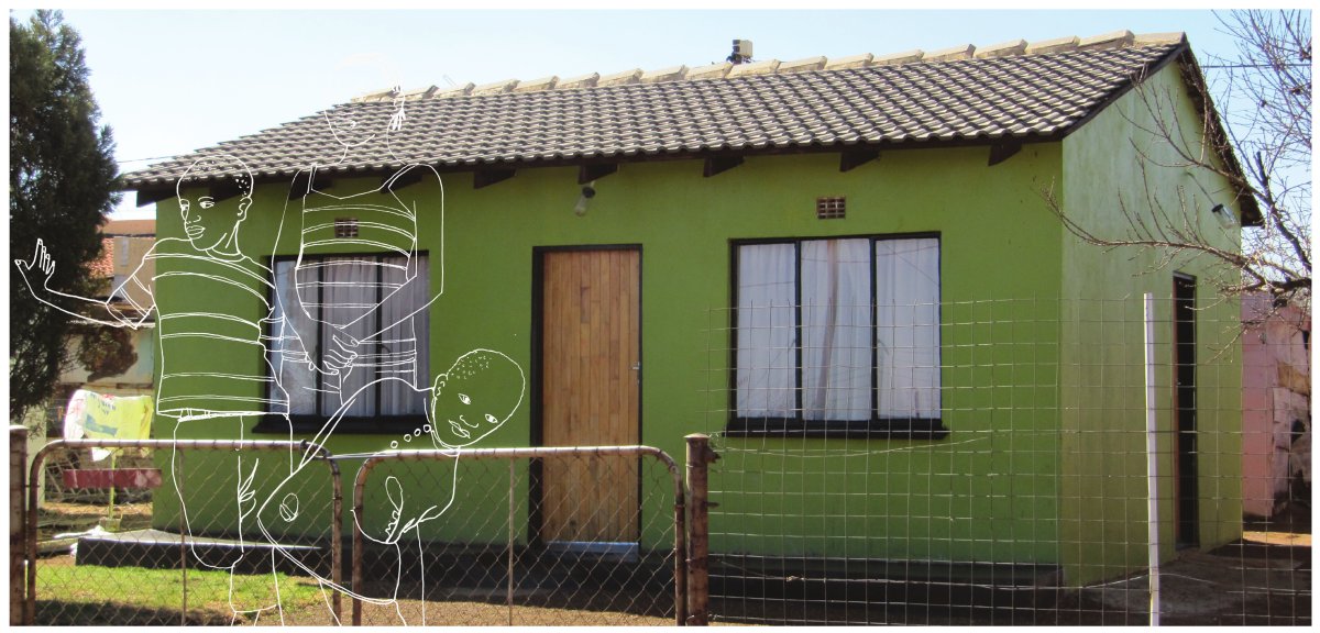
SUBSIDISED HOUSING ASSETS
Exploring the Performance of Government Subsidised Housing in South Africa
Finmark Trust
South Africa’s national housing subsidy programme, which was introduced with the advent of the first democratically elected government in 1994, has been lauded internationally as a highly significant and ultimately successful housing intervention. The programme provides qualifying beneficiaries (households who earn a monthly income of less than R3500 per month and satisfy other criteria) with freehold tenure over a 40m2 house on a 250m2 plot of serviced land. It is highly likely that the significant increase in the number of South African households living in formal dwellings between 1996 and 2007 – from 64.4% to over 70% - is primarily as a result of this national subsidy programme. The National Department of Human Settlements reports that between 1994 and 2009, a total of 2.94 million subsidy houses were either delivered or still under construction. Of these, 1.44 million (51%) have been formally registered in the Deeds Registry. These registered subsidy houses comprise just under one quarter (24%) of all registered residential properties in South Africa – clearly a significant proportion of South Africa’s property market.
In 2010, the FinMark Trust, with support from Urban LandMark, the National Department of Human Settlements, the South African Cities Network, the Western Cape Department of Human Settlements and the FB Heron Foundation, undertook a study into the performance of government subsidised housing units. The study involved an analysis of how subsidised properties were trading formally, on the deeds registry, and then a series of household interviews with a small sample of respondents from three settlements. As a first step, the study fed the database of all subsidy applicants who had been approved for a subsidy between 1994 and September 2010 into the Deeds Registry. By matching applicants with properties, a total of 1,7m subsidy applicants were identified as the property owners of 1,44 million properties. Half of these properties (49%) were found to be located in the eight metropolitan cities, with Ekurhuleni (141,104 properties), Cape Town (130,300) and the City of Johannesburg (130,121) having the highest number of registered subsidy houses. The highest number of registrations across the provinces was found in Gauteng (395,765), the Eastern Cape (238,682) and the Western Cape (208,852).
Invisible Informality
Assuming that all the 2.94 million houses had been developed by September 2010, this implies that almost one and a half million subsidy beneficiaries had received a subsidy house without the registration of formal title. This creates a sort of ‘invisible’ informality: households who have received a formal housing unit, but who have not yet received a title deed. While they may feel themselves as owners, their legal status is informal.
From 2005 there has been a consistent decrease in the percentage of subsidy houses that are being registered and this trend is continuing. The removal of the requirement that registration is required before the release of a significant portion of the subsidy payments in April 2004 appears to be a key contributor to this trend.
The obvious value of a title deed is that it protects rights to a property and records changes in ownership. Title deeds also provide individuals with an address, recognising the owner as being part of the municipality, and enabling the owner to secure loans. The house can then be inherited – this is an especially important aspect of the house as described by respondents. The failure to provide Title Deeds to subsidy beneficiaries means that they are being denied a critical (and promised) point of entry into the formal property market.
Also, not having a registered title means that beneficiaries are not able to sell their houses formally, using the
Deeds Registry system (which requires the seller to have a Title Deed). As a result informal transactions are
occurring, creating a second generation of invisible informality. These transactions undermine individual property owners’ security and more generally the integrity of the Deeds Registry system in South Africa.
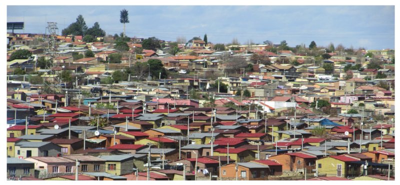
Continued on Panel 2
.
FINMARK TRUST
Subsidised Housing Assets (Panel 2)
SUBSIDISED HOUSING ASSETS (panel 2)
Exploring the Performance of Government Subsidised Housing in South Africa
Finmark Trust
Why is there a delay in titling?
Research commissioned by Urban LandMark points to several factors that undermine the transfer of title to subsidy beneficiaries.
- Delays in the township establishment process and proclamation
- Revisions to the project payment process in the development of subsidy houses
- Failure to hand over title deeds
- Appropriateness of the deeds registration system
The major cause is a failure by developers (both government and the private sector) to finalise the establishment and proclamation of new areas being developed for subsidised housing. Projects go ahead without the approval of a General Plan for the area, largely because the players involved, lack either the time or expertise (or both) to address the many underlying issues that need to be resolved on certain tracts of land. Legislative, administrative and situational difficulties all contribute to the challenges. With the immense pressure on government officials to deliver housing at scale, the processes of township proclamation are sometimes short-circuited in favour of getting houses on the ground quickly.
In part because of these challenges, the project payment process for subsidy housing was revised, ironically creating another factor undermining the legal transfer process. Originally, the registration of the title deed in the name of the beneficiary was a key milestone against which a developer would have to perform in order to get paid. This meant that in the more complex developments, time delays associated with the registration process undermined the viability of the development. In 2003, therefore, the progress payment system was changed to allow for payment of the completed top structure before the registration of transfer. This means that developers can now be fully paid out without having to ensure that the title for the property is put into the name of the beneficiary. As a result, the registration of deeds for subsidy properties has progressively declined since 2003. In 2009, less than a quarter (23.4%) of all subsidised properties reported as having been delivered were formally registered in the deeds registry. And this was an improvement on the low of 16.4% registered in 2007.
In some cases, while the property has been registered, the title deed has not been handed over to the beneficiary. The Department of Human Settlements has reported on this phenomenon to Parliament, indicating that many beneficiaries have still not collected their title deeds after they have been processed (and after having resided in the premises for several years). In other cases, title deeds have been held back by the conveyancer due to non-payment of fees by the project owner – usually the province or municipality or their appointed contractor.
Of course these issues, and the experiences they describe, raise the question of the appropriateness of the deeds registry system, specifically with regard to subsidised properties. Some experts have suggested that while the residential property conveyancing system in South Africa is thorough and legally sound, it is far too complex for small transactions. The conveyancing process is also relatively expensive in the subsidised housing market (given the value of the transactions involved), and generally inaccessible to low income earners wishing to engage in what is sometimes their first-ever property transaction. When the state fails to assert the formality of their tenure through the delivery of a title deed, the inflexibility of the deeds registry system challenges even further their capacity to overcome their invisible informality.
“We have a first-world deeds system in a developing-world spatial context. We need to question the very necessity of title deeds”. Former Land Title Adjustment Commissioner.
The phenomenon of informal sales does not only occur in respect of beneficiaries who do not have title deeds, but also in respect of those who received title deeds. Even if the owner has a title deed, the process of formal transfer is complicated, can take between three and six months and the costs involved can be prohibitive for the “purchaser”. For these reasons individuals bypass the formal sales process – living informally in formal housing.
This approach may ultimately lead to a lighter, more flexible and responsive form of urbanism which accommodates local desires, narratives and initiatives. Rather than abandoning our clients in the light of limited budgets we have pooled human resources through combined networks in order to realise our mandate of creating a public space for cultural programme.
Back to Panel 1
.
FINMARK TRUST